

RDRY
-
Posts
686 -
Joined
-
Last visited
Content Type
Profiles
Blogs
Forums
American Weather
Media Demo
Store
Gallery
Posts posted by RDRY
-
-
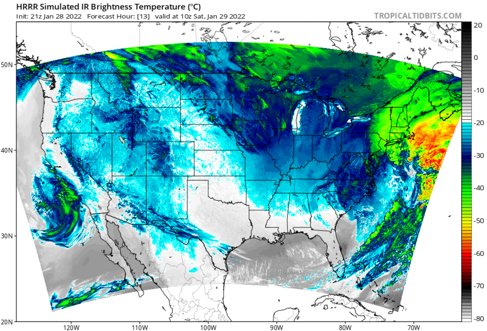
Potent energy on the CMC -- this would deliver for many. Drop it 100+ miles south, and it would REALLY deliver.

-
12 minutes ago, MJO812 said:
Too early to tell
It was rhetorical, but even at this long lead time this one looks bleak.
-
1 minute ago, MJO812 said:
Gfs closer
Will that northern energy act as a kicker or a magnet?
-
9 hours ago, George001 said:
I disagree. We have seen a trend towards more big ones yes, which explains why seasonal snowfall averages have increased. However, it seems like it’s harder and harder to get marginal systems to go our way. I do think climate change is a big part of this, as the warmer oceans help beef up storms, which helps us get more big ones. However, a warmer background state also works against us in more marginal events where we don’t have those dynamics. Although snowfall averages have increased here, they have decreased in areas to the south. The earth is getting warmer, and the rate of that warmth is accelerating. There’s a reason why every year we hear “this year is a top 10 warmest year on record”. 2021 was tied for the 6th warmest year on record in a goddamn raging La Niña. La Niña is a cyclical weather oscillation that favors COOLER average global temps, yet last year still was one of the warmest on record globally. You aren’t wrong about cyclical weather cycles, but climate change plays a huge role as well, and that role is getting bigger and bigger every year.
The Earth has been spinning for over 4 billion years. The "warmest year on record" trope that encompasses a couple hundred years is absurd. But it makes for an excellent sound bite.
-
 3
3
-
 1
1
-
 9
9
-
-
29 minutes ago, HIPPYVALLEY said:
Meh
NAM puts the Berks back in the game for decent snows.
-
Are the models programmed to always vehemently disagree with each other?
-
 5
5
-
-
Lots more moisture this run after the frontal passage.
-
GFS pulling a '94.
-
5 minutes ago, HIPPYVALLEY said:
Not getting the trends we want to see. SNE looks cooked, not sure how amped up this can actually get with this set up but NNE looks safe.
Ski areas in the Berkshires and S VT can't afford to be losing base though.

As long as the freezing boundary stays within 50 miles on the models, this has a shot for the Berks. That's some serious cold air, and the southern system just isn't that strong.
-
1
-
-
18+ hours of snow on GFS. That's a ski resort weenie run.
-
Bands bullying their way north and west. Positive NAO can have its benefits.
-
1
-
-
Radar looks great. Bands with no problem advancing north and west.
-
3
-
1
-
-
2 minutes ago, nycsnow said:
Hrrr gonna be a little better
Yup. Compare with previous run -- the southwest low is robbing energy from the northeast low.

-
1
-
-
A bit better HRRR run so far through hour 9. Millibar stronger and leaning northwest. Through hour 12, definite improvement.
-
3 minutes ago, Monmouth_County_Jacpot said:
No double low so there’s that
It's still there.

-
1
-
-
Just now, MJO812 said:
It's focusing on the eastern low
That's baked in at this short lead time. The 2 feet-plus totals are likely off the table for everyone, except maybe the Cape.
-
The storm chases the convection on the hour 22 NAM and splits into two lows at hour 23. Then it takes until hour 29 for the western low to take over, but it's further east and 8 MB weaker than 6z. And moves east instead of north once it does.
This all likely happens because the trough shifted slightly east, which bumped the initial surface low just far enough east to where it could chase that convection.
-
1
-
-
NAM's fun, but no real support for jackpotting NYC.
-
1
-
-
8 minutes ago, Jt17 said:
0z at Hour 30:
almost looks like it consolidates the double lows entirely to the west and it's pretty close to the coast...

Compared to 18z at same time:
But because it doesn't fully consolidate, at hour 33 on 0z it jumps east about 30-40 miles. How far is nyc out from the bullseye... just saying
")
I think the modeling is pretty locked in on this being a Long Island special. The city may see a mega band or two traverse the area, but they'll be camped out on the island for the duration.
-
Anyone thinking the GFS will pull a big cave don't know the GFS. Probably a nice shift west, but still an eastern outlier.
-
2 minutes ago, MANDA said:
Definite improvements on 18Z NAM. Does not do much to help us west of I95ers but much better look for bigger snows I95 south and east and across LI. Window is closing for western and northern areas for anything more than a minor to perhaps moderate event.
With a 960s low in that spot with that track, you'd have to think the precip shield should be more expansive to the west.
-
At 48 hours, it's 5 MB stronger and a bit more north, but the precip shield is less expansive. Odd. Maybe it's more occluded.
-
Here's hoping this GFS run ingests bad initialization data, and is discarded.
-
1
-
-
1 minute ago, HIPPYVALLEY said:
I would be content if we can pull 6" in NW MA, don't care if Ray or whoever gets 26" we just need more snow otg here.
Looks like the Berks get in on some decent wraparound snows and probably some upslope with the NAM -- the upper levels looked better than 6z, but the surface didn't really reflect it.


Feb 13-14 snowstorm/nor’easter potential
in New England
Posted
Then it can't disappoint.