

RDRY
-
Posts
686 -
Joined
-
Last visited
Content Type
Profiles
Blogs
Forums
American Weather
Media Demo
Store
Gallery
Posts posted by RDRY
-
-
-
8 minutes ago, Snow88 said:
No we haven't. Not with a negative epo pattern.
This still feels like an interior-and-north event for mainly snow. That SE ridge has been fierce.
-
 2
2
-
-
We're like diabetics enjoying a spoonful of chocolate mousse.
-
1
-
 5
5
-
-
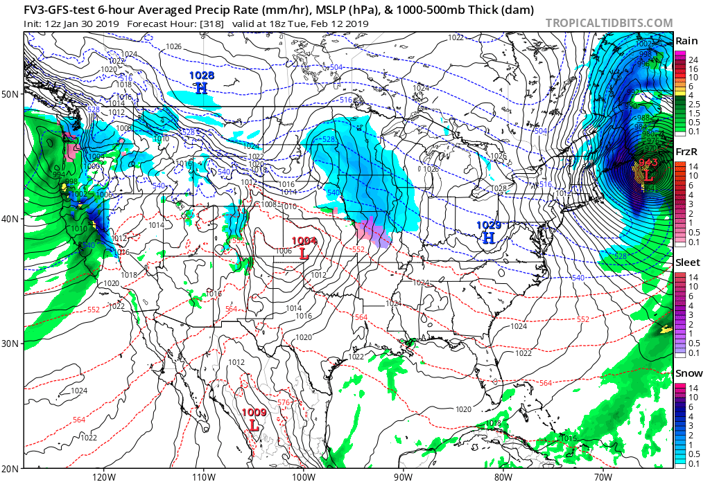
A 943 low east of Maine. Now that's funny.

-
1
-
-
10 minutes ago, NorEastermass128 said:
That line of thunderstorms from RI to FL. Pretty darn impressive.
28F / -FZRN
The futurecast radar runs that line into Guatemala.
-
14 minutes ago, ORH_wxman said:
This is one of the weirdest storms I've ever tracked. I've never seen models insist on plowing into an Arctic high like this. Ever. If someone can find me an analog, I'm all ears but I've searched. Nada. Ok expecting a huge bust on low level temps by the models. But I'm def gonna be wrong on the colder tick aloft I was expecting.
But this Arctic "high" is more like a band of cold air than an actual high pressure center. There's almost no north-south orientation to it, so any southerly flow has tons of room to push north.
-
5 minutes ago, WxBlue said:
1037 mb high pressure screams "I'M A CLASSIC ARCTIC HIGH" to me. It's laying down the cold air at all levels ahead of the storm.
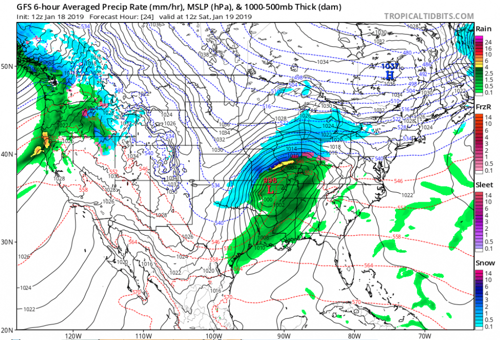
The position and strength do look classic. But - maybe this is a complete misinterpretation on my part - the isobars around the high do not look classic. They aren't curved. It looks like just a fast, flat flow of Arctic air, which may explain why many of the models are forcing the system so far north, as the high is not really pressing south. If anything, it's giving up a little ground.
-
GFS seriously needs to be scrapped at this point. Just start over.
-
The GFS and its illegitimate brother zig when the other models zag.
-
Don't think it's much of a factor, but the Western ridge is getting beaten down a bit more by a system moving in.
-
GFS finds the soft spot in the high pressure zone and attacks it.
-
3 minutes ago, Ericjcrash said:
Not with that tropical air screaming up torching the mid levels. Surface could very well stay freezing in that setup, but not aloft.
I'm considering freezing rain frozen precip, but yeah. No way this stays snow for the coast per the Euro.
-
The SLP track is just slightly north of due east from 120 to 168, and stays south of NYC. That should keep this mostly frozen.
-
7 minutes ago, RU848789 said:
Anyone else surprised at the AFD from Mt. Holly, below? They only mention rain, when they must've seen last night's snowy runs and at least today's snowy 12Z CMC and 12Z Euro (even if more of a coastal snowstorm), but it's almost as if they only looked at the rainy 12Z GFS/GFS-FV3. OKX was at least more non-committal, just mentioning heavy "precip" possibility.
National Weather Service Mount Holly NJ
647 PM EST Sat Jan 12 2019

LONG TERM /MONDAY THROUGH SATURDAY/...

Friday and Saturday...the quiet weather comes to a close as an upper-
level trough begins to amplify across the central U.S., leading to
cyclogenesis and deepening of a surface low as it moves across the
country. The Rossby Wave pattern becomes highly amplified, thus
stretching an area of PV across the eastern U.S. The synoptic trough
thus looks to become quite broad as it moves into the eastern U.S. A
strong baroclinic zone looks to set up over the Mid-Atlantic, which
will likely aid in the maintenance of the surface low and
provide sufficient isentropic lift. This has the look of a
potential heavy/prolonged rain pattern, thus will need to watch
the evolution of this system over the coming week. Global
forecast models are suggesting a fairly moist pattern will take
shape ahead of the developing surface low, with widespread
rainfall, though the heaviest does appear to be over the open
Atlantic at this time. Otherwise, with southerly flow starting
Friday, highs will nudge upward into the low 30s across the
southern Poconos to near 50 across southern Delaware.
National Weather Service New York NY
705 PM EST Sat Jan 12 2019

LONG TERM /MONDAY THROUGH SATURDAY/...

Model spread increases through the weekend on
amplitude/orientation/timing of a developing deep eastern trough,
dependent on earlier mentioned northern/southern stream interaction.
The implication is potential for a parade of lows pressure waves
developing along an increasingly longitudinally oriented cold front
extending down into the Gulf of Mexico. With sub-tropical connection
ahead of the troughing, moderate potential exists for heavy
precipitation into the Mid Atlantic next weekend, possibly working
into the local region. Sensible weather details will be dependent on
evolution of the northern/southern stream interactions and
position/orientation of cold front. Will likely be a few days before
the main players come into better sampling range to increase
confidence in the details of this part of the forecast.
They're the top mets. I'll pay it some mind.
-
The new GFS 12z was on crack. That would be biblical.
-
Has the new GFS been better or worse than the current one? It seems to be much more erratic.
-
11 minutes ago, 40/70 Benchmark said:
I edited that....didn't mean to be jerk.
My bad.
NP. Didn't take it that way.
Anyway, a flatter pattern can work just fine with decent cold air to the north -- those storms are usually pretty easy to forecast a few days out. Less angst over coastal development timing, blocking, minute track adjustments, etc.
-
5 minutes ago, 40/70 Benchmark said:
I could not give a rat's a$$ what the trend was from 11/18 to 1/20.
None.
Zip.
Zero.
Nor should you. It was just an observation of a pattern we haven't seen much of in a while.
-
1
-
-
One things seems pretty clear this winter -- northward model adjustments will not be the rule of the day. Flat and fast flow.
-
8 minutes ago, SnowGoose69 said:
If you go to the ncep page and change the web address portion from “mag” to “mageval” you can get it or it’s on tropical tidbits under FV3-GFS under global models
Tidbits has the 6z
-
1 hour ago, wdrag said:
On late12-early 14... I follow ensembles in general and I think we have an event coming per GEFS/EPS/GEPS. ( I definitely think the FV3 has problems and am not looking forward to the change, but it must come, because I think thats what the modeling world needs, to make a substantial improvement on the GFS~ 2020-21). In this situation, I want to see the GGEM OP come on board. Until that happens... my confidence on type/size are with doubts but it seems at least a grazer .1 to .5" qpf NYC/NNJ is coming with potent "options" for a bigger storm. An event has been in the modeling for many-many days. I wont be able to restudy this in depth til either this evening or early Tuesday. I think (not sure if its already up) its time we start a thread on snowfall/ice amounts observations from 6PM this evening through 10AM Tuesday for this first minor event centered on the 8th n and w of NYC. That can keep the conversations separated when the first little batch of precip arrives this evening. Have a good day. Walt
Has the new GFS been worse than the old one? If so, how can the NOAA make the switch?
-
This was a perfect "storm" for commuter chaos. A mid-November forecast of an inch then rain right up until game time. Followed by early to mid afternoon inch-an-hour, sticking snows. The city had no chance on this one.
-
4
-
-
1 hour ago, Metasequoia said:
A clear win for the EURO.
What else is new. I thought the GFS was getting an "overhaul."
-
1
-

February 2019 General Discussion and Observation Thread
in New York City Metro
Posted
It's also showing some upper-air energy dropping south on the back end, which keeps light snow going.