

RDRY
-
Posts
731 -
Joined
-
Last visited
Content Type
Profiles
Blogs
Forums
American Weather
Media Demo
Store
Gallery
Posts posted by RDRY
-
-
1 minute ago, The 4 Seasons said:
Same. Not sure how you can go with a model that is an extreme outlier, not to mention its newer counterpart is in the main camp.
Are you guys doing a map for SCTWX?
The para is the upgraded GFS? Seems very erratic.
-
Of the 4 main globals, I assume Euro verification is still #1. Which one is 2nd?
-
Not surprised. GFS does this -- goes off on its own and holds for several runs. It's always possible it has the better read on this storm, but it's not likely. The ICON in its corner like Jack the Ripper as the cutman.
-
Nitpicking the end of a 12k NAM run, but it's weird that the low doesn't deepen (996) between 78 and 84 hours.
-
Classic GFS at this range. It goes rogue and holds its solution for several runs before joining the party.
-
5 minutes ago, ORH_wxman said:
00z icon is crazy amped. Getting big banding into dendrite land.
Ukie running late..it was pretty flat at 12z and was hoping to see if it trended north at all at 00z, but I’m not waiting up for it any longer. Euro can wait 4+ days out.
Does the ICON have any known biases? To my very untrained eye, it just always seems to be erratic.
-
GFS has about the same low position approaching Jersey. But the high wins the battle with the weaker system.
-
12 minutes ago, powderfreak said:
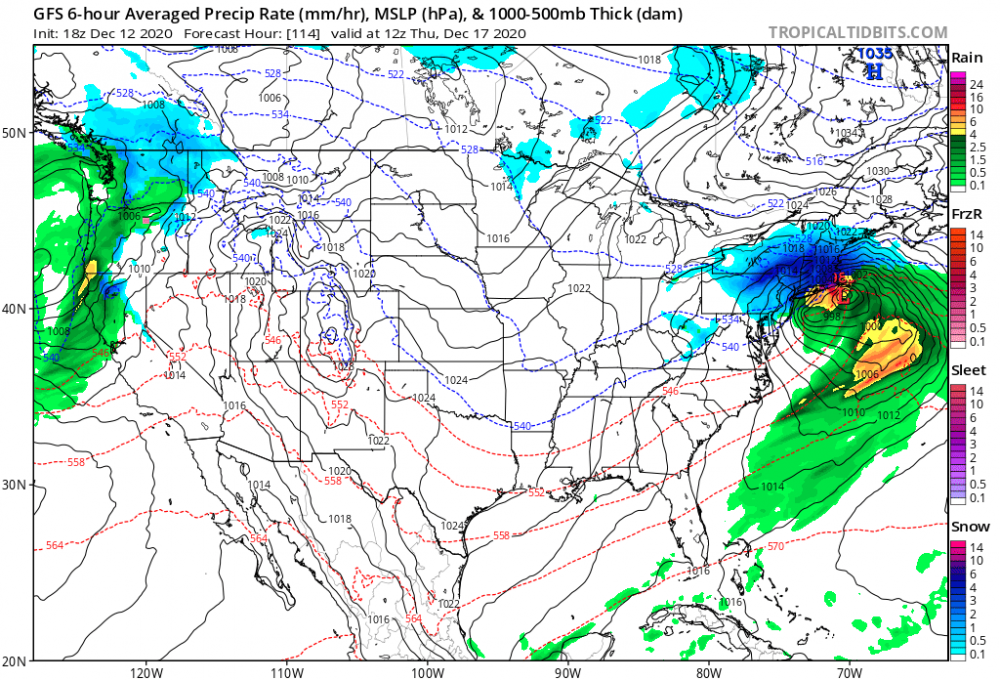
What a set up for the mid-Atlantic and SNE... that shortwave running into a 1036mb high north of Montreal.

Strong shortwave -- check
Arctic high + block -- check
Gulf moisture -- check
Atlantic moisture -- check
-
 1
1
-
-
21 minutes ago, MJO812 said:
Winter storm flynn
Steve Cohen and a mid-December nor'easter. Spoiled.
-
2
-
-
Trough sharpened up at 102. Makes the difference.

-
Alrighty then.
-
23 minutes ago, WxWatcher007 said:
Be careful, some of our "friends" to the north would gladly see us all rain so that they can cash in. Gotta be vigilant around here. Snow is serious bidness.


-
Just now, weathafella said:
Definitely Boxing Day. You should have seen Tip's melt! I ended up getting into the Boston band and got 18 inches but not far from me got screwed. I'm not sure Jan 96 qualifies. I was on the west coast in 1983 so I can't comment.
March '93 would have been the reigning king if it could have nudged another 100 miles east. As it was, craziest storm conditions I've ever seen.
-
11 minutes ago, weathafella said:
I thought that storm just didn't gain enough latitude for north of the Pike to get the huge totals. But I loved that storm. Snowed on a deep pack.
Jan '96, Feb '83 and Boxing Day -- Queens top 3.
-
14 minutes ago, BombsAway1288 said:
Early occlusion is usually best for WCT/NYC and SW of there.
Storm blowing it’s load too early is usually never good for NE
I believe January '96 was a classic example.
-
15 minutes ago, 40/70 Benchmark said:
More occlusion, sharper cutoff..not all good.
I remember that storm with a pretty limited northwest precip field. And isn't early occlusion typical for the bigger east coast storms?
-
Much more expansive precip field than last week's storm. Much stronger high. Slower mover. All good things.
-
Just now, CoastalWx said:
If you are anywhere, especially CNE on south you are in the game. West....east....all in. I find it hard to think this doesn’t tick NW.
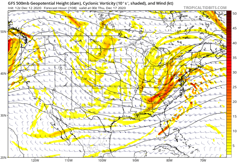
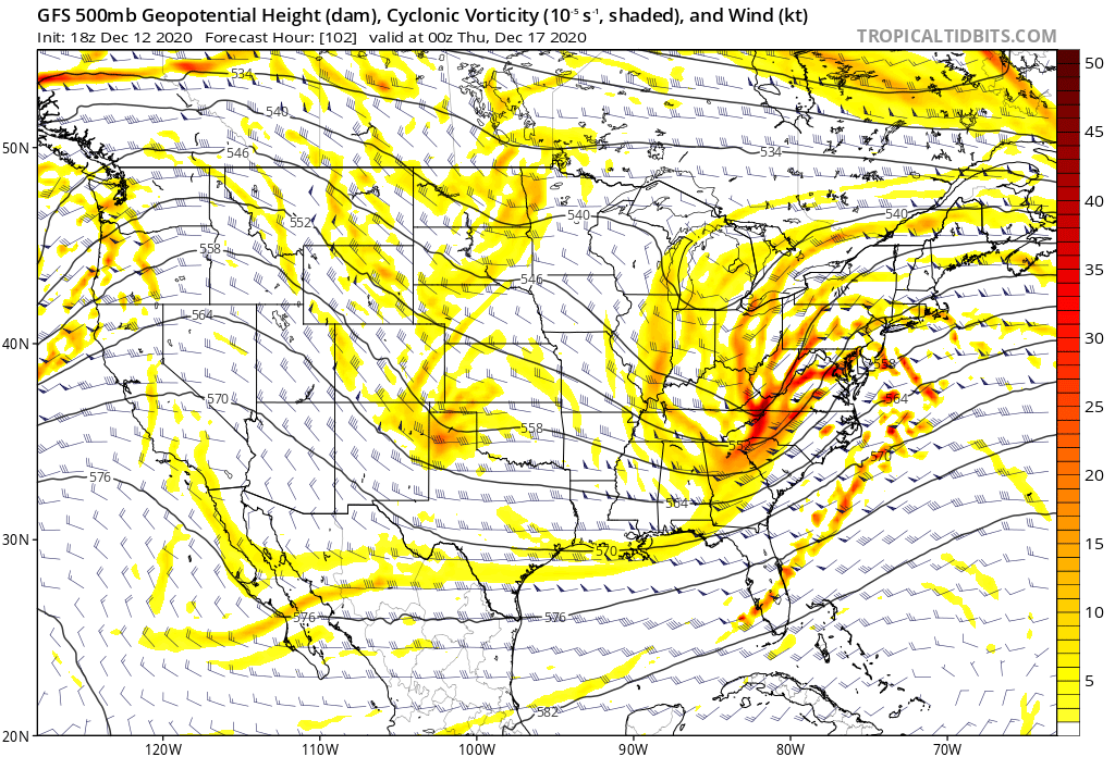
Gotcha. The GFS 500 chart just doesn't look like a classic western-CNE hit. The good dynamics are shunted south and east.
-
1 minute ago, CoastalWx said:
Yeah agree. No chance. In fact maybe not past Nantucket.
I should have specified western Mass.
-
Upper levels just don't support this hitting north of pike. The 500 MB trough orientation is more east-west than north-south.
-
 2
2
-
-
Low is forced east -- even a tic east-southeast -- from southern New Jersey, suppressing the heaviest banding south of western Mass. That high means business.
-
2 hours ago, CoastalWx said:
6z EPS loks great.
So, the 6z Euro only runs to hour 90, but the 6z EPS runs longer?
-
3 minutes ago, 40/70 Benchmark said:
GEPS are nice....GEFS?
What is the difference between the GEPS and GEFS?
-
An east coast bomb in (what looks to me) a mostly zonal flow. Is that really feasible?
.thumb.png.3e5d7bfd7aae5cf47961ffb7fa940a50.png)


.png.acc6d47bfbc7d506b3784b73ee93aedb.png)
Active mid December with multiple event potential
in New England
Posted
Upper levels just don't support this hitting north of pike. The 500 MB trough orientation is more east-west than north-south.