

Paleocene
-
Posts
1,030 -
Joined
-
Last visited
Content Type
Profiles
Blogs
Forums
American Weather
Media Demo
Store
Gallery
Posts posted by Paleocene
-
-
1 minute ago, jayyy said:
If the low takes that track along the white line, there will be a ton of surprised people come Wednesday PM.
updated version of that map updated at 12z here: https://origin.wpc.ncep.noaa.gov/wwd/lowtrack_circles.gif
-
35/26 in the 20910. Which is an anagram of 90210. There, it is 72/47. Why do I live here again?
-
12k nam holds the surface freezing line SE of 95 through 18z tomorrow. not bad.
And, edit, 850's spike above freezing between 19z-23z tomorrow. All the way up to M/D line, but they crash after that.
-
38/21 in Silver Spring at my kid's elementary school. High clouds movin in.
With less people commuting and less energy being expended at places of work and commerce due to the pandemic, the UHI effect will be lower, right?

-
 1
1
-
-
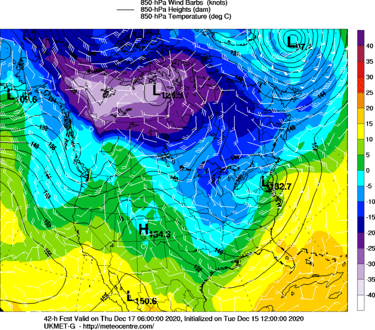
Ah, the low at the classic Philadelphia benchmark. Thanks UKMET
-
 1
1
-
 6
6
-
-
When can we start the nowcast/obs thread so I can stare out my window and say SLEET once before I get rain at 34 degrees for 6 hours tomorrow?
-
1
-
1
-
-
4 minutes ago, paweather said:
What map are you posting?
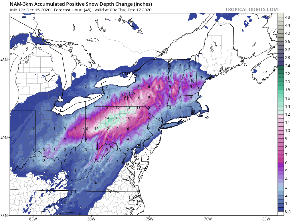
I used the accumulated positive snow depth change. Your map includes sleet -- as snow. Good luck to Palmyra! My grandparents live there.
-
1
-
-
Welp. Hope I see a bunch of sleet in Silver Spring before it changes to rain tomorrow afternoon. Good luck to the northern tier.

-
3k nam has the primary low traveling west of norfolk NE-ward across the bay into the southern eastern shore.
-
Just now, WVclimo said:
Damn, central PA is gonna get nuked. I'll try to get my mom, who used a 2011 potato as a smartphone, to send some pics from Harrisburg around 800 ft ASL
-
1
-
3
-
-
1 minute ago, adelphi_sky said:
I'm in the sky blue stripe. 2-4. I'll take it. I promised my son it was gonna snow.

Same here. Don't want to disappoint a 7 y/o. Good luck! I'm prolly 2 miles west of you, a bit higher up.
-
I know when I start switching my expectation from rooting to snow to rooting for sleet, things aren't looking good. I was hoping this would be like the feb '14 miller A(?) storm that gave me 5-7" ish inside the beltway (plus rain/sleet mix) while NW areas got 12"+.... but last 24 hours of trends have me thinking that's an unlikely scenario.
But such is climo where I am :-D
-
2 minutes ago, WinterWxLuvr said:
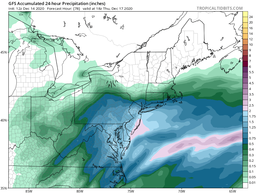
One thing that isn’t being mentioned is how the gfs seems to get a little bit drier each run
12z today for 18z thurs 24 hour precip, versus 00z last night for same time.
I see a different spatial distribution especially comparing north of M/D to south. I like being centered just outside DC in that 1.5 inch zone..prob is its looking increasingly liek a chunk of that will be rain/sleet :-(

b.thumb.png.4027e55ba16b8e3291530f622a285215.png)
-
Man, I am loving that look on the 18z GFS. Please GFS gods, give us that heavy axis here right along the fall line. I'm in Silver Spring (just east of downtown near route 29) and I'm on top of a hill at 326'. My friends in Hyattsville or Brookland DC could see significantly less than me, a few hundo feet lower.
-
Just now, CAPE said:
Nothing like a 120 min IPA. Insanely malty, insanely hoppy, and a tad sweet. Some serious food value along with the high abv.
I have a four pack of these crispy boys waiting in my pantry. Got them from the source at dogfish HQ in Milton in November. Will def crack one if it snows on weds eve.
-
1
-
-
1 minute ago, JakkelWx said:
That'll be a hell of a midnite jebwalk.
-
This looks really pretty to my meteorologically uneducated eyes. Pretty cool to see that 50/50 and the block.
I remember past discussion of neutral or negative tilt being desirable for the area of low pressure in the southern US, this is relatively neutral right?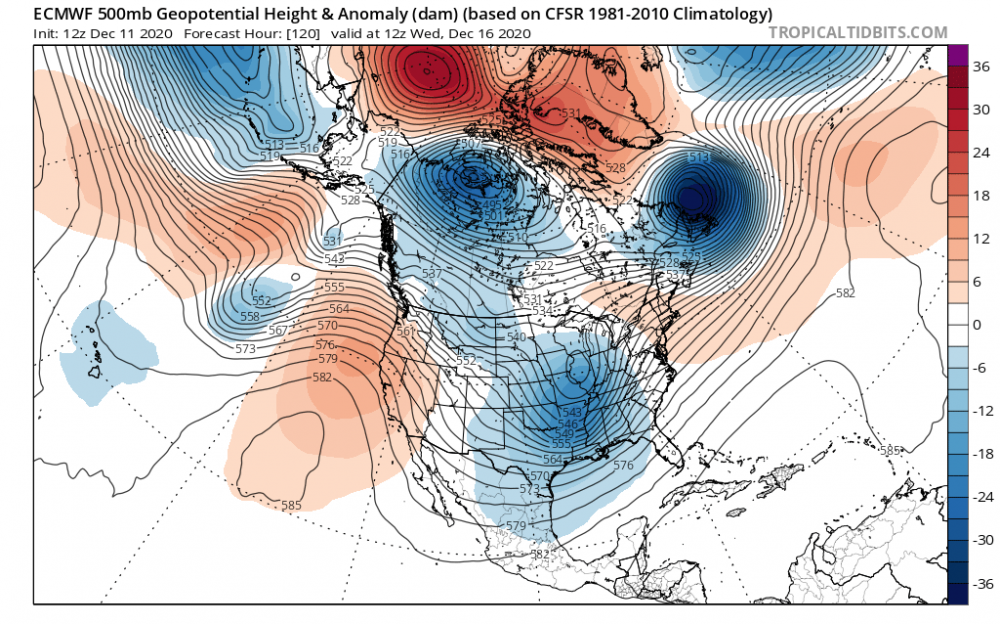
-
1
-
 1
1
-
-
1 minute ago, MN Transplant said:
Good news remains that it is full of moisture. 1.5"-1.9" through most of MD and N. VA.
This is good news indeed. I'll take my chances inside the beltway with that. 5 days out to get temps right...
-
Great CAD signature at 120 hours on the euro.
-
2 minutes ago, NorthArlington101 said:
GEFS also looks great. Somewhat icy for a good chunk of VA verbatim but it's a good run.
Here are the fresh GEFS ensemble lows. that is a hell of a cluster east of assateague

-
1
-
-
Don't want to spam the thread with pics but holy smokes the CMC buries i-95 corridor
-
1 minute ago, WxUSAF said:
GGEM incoming

cranking!

-
3
-
-
GFS 12Z on 12/11, for 12z thurs 17th. Capturing the projected wednesday storm 12/16

-
Freezing line at hour 126, at the surface, basically parallels I-95 south of baltimore. 850s line runs through charles, anne arundel, queen annes
b.png.9dbe5c19d86629dcc626c9744bf39f00.png)


December 16-17, 2020 Winter Storm Obs/Nowcasting
in Mid Atlantic
Posted
I thought that at first glance but the fine print at the bottom says lows historically verify... 75% of the time.. within those big yellow circles. So uh, that's a large error range.