

Hyphnx
-
Posts
281 -
Joined
-
Last visited
Content Type
Profiles
Blogs
Forums
American Weather
Media Demo
Store
Gallery
Posts posted by Hyphnx
-
-
41/21
Dropping quick
-
Just now, BristowWx said:
That model is consistent if nothing else. Hug it like a warm lab puppy. 37/13
It robs RIC though. I think this precipitation expanse will change things
-
 1
1
-
-
Precipitation expansion is wild. 00z models should have totals go up.
42/24
-
2 minutes ago, Sernest14 said:
even 3k 18Z looks much slower and less expansive
19Z Tues
01Z Wed
But when that snow line hits us in the NAM 18z.. it's a ton. Like.... high ass rates.
-
18z seems to be ramping up the percip per hour. Tons of dark blue. From RIC to DC
-
 2
2
-
-
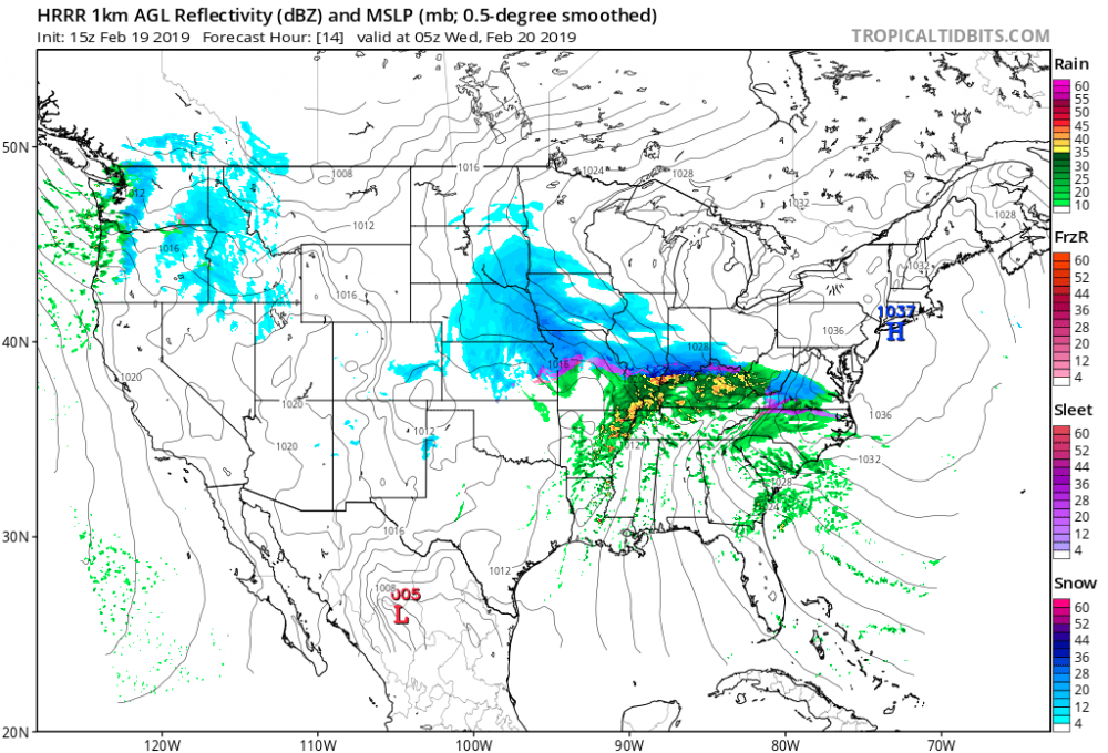
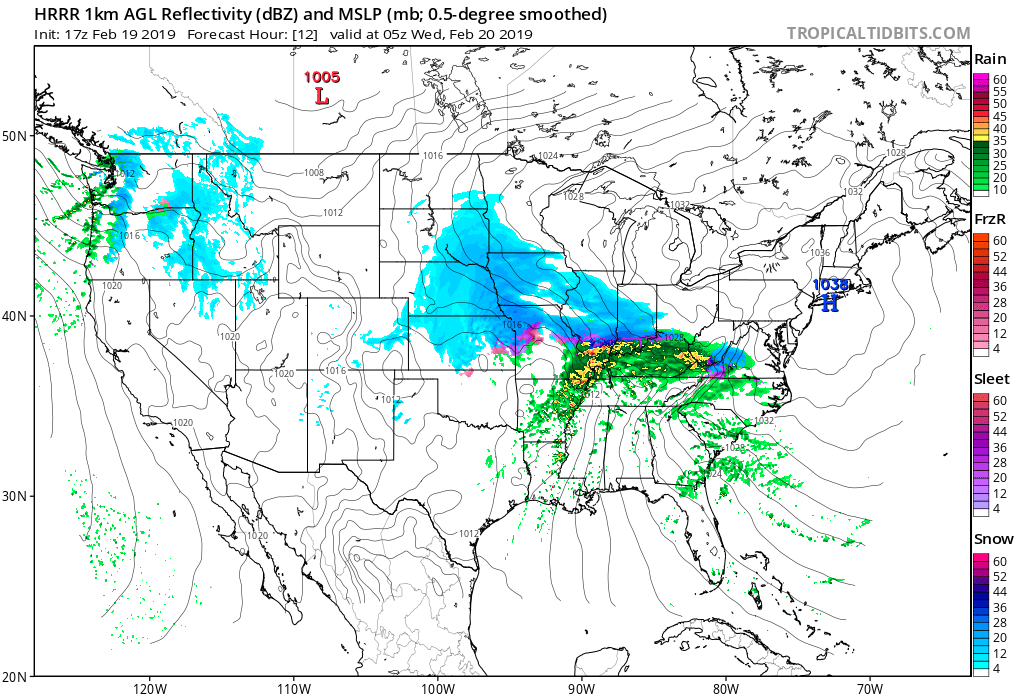
Each run of the HRRR is less and less
-
3 minutes ago, psuhoffman said:

Not much different.
HRRR has a smaller precip field at 05z at the WVA and VA border. Not as expansive as it was in earlier runs.

-
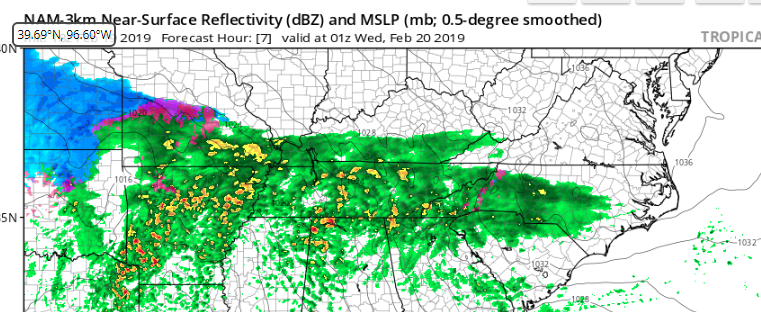
FV3 has light snow starting at 03z in RIC. Still snowing at 06z and the snow reaches DC at 06z. Ice starts in RIC at around 12z and the heavy snow reaches DC at 12z. Sleet begins in RIC at 15z, heavy snow in DC at 15z before the flip.
-
2
-
-
3 minutes ago, mappy said:
^^ talking about Richmond.
Folks, if you are going to be doing model play by play, please please please be specific on what area you are talking about when you do so.
Just now, Eskimo Joe said:This. Especially if you're on mobile, it's hard to understand where a poster is talking about.
Apologies.
3 minutes ago, BristowWx said:in RIC? so you are frozen until that point? interesting I wouldn't have thought that. location dependent there too for sure.
This was per the 12zNAM, subject to change.
-
Rain switch over seems to be happening around 4pm *in Richmond*. Ice looks to be a threat more so than before. I think the models are picking up on the CAD
-
12z NAM looks to be coming in hot. Dry Slot at 08z in RIC. I'm sure it's a model hiccup.
-
5 minutes ago, Wonderdog said:
I figured they were. How is the ICON viewed as a model?
We are probably at the Mesoscale time, Ensembles might catch something in a run but the Meso is what we are wanting to watch.
-
1 minute ago, NorthArlington101 said:
It's an all time weenie run. I posted this in banter but it shows 4" an hour for CHO at the heart of the thump. And then it's sleet central.
HDRPS isn't the worst model out there. Did well on the December storm.
FV3 did well on that storm, if I recall correctly.
-
Just now, snjókoma said:
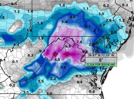
No scale but the pretty purples and pinks = 6"+
RIC looks to be mostly sleet, again. Hoping they catch the CAD and temps will be lower.
-
Heavy snow in RIC at 10z on Wed, per the 3K NAM. Doesn't look to transition over to rain until way later.
-
18z NAM is looking colder. More ice than compared to the 12z
-
1
-
-
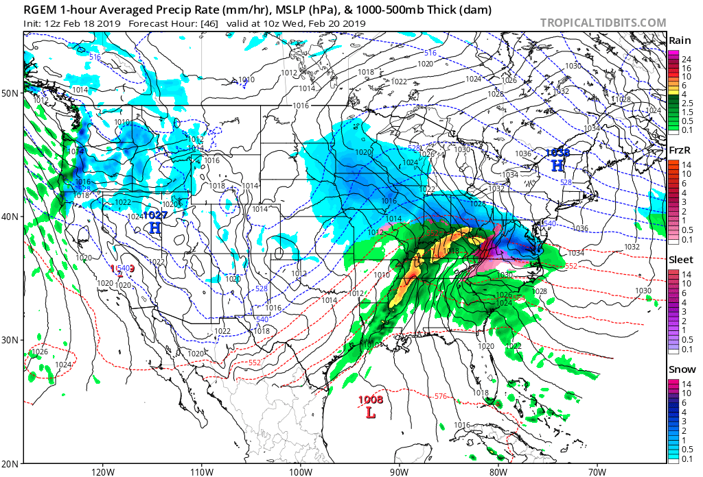
RGEM showing heavy snow in CVA at h46. Still snowing at h48 with the ice coming in around h50.

-
1
-
-
2 minutes ago, NorthArlington101 said:
Snowing everywhere expect NE MD by 72, thumping Central VA. Headed up towards DC.
Thumping??
-
NAM is showing Central Virginia not moving out of the cold stuff until around 5pm. Morning and afternoon commute will be horrible.
-
GFS looks colder.
-
Boost season is upon us
-
Just now, BTRWx's Thanks Giving said:
Not only that, but I remember it getting all the praise then as a good model.
It did well for the 12/9 storm, too
-
2
-
-
3 minutes ago, MD Snow said:
Gfs souther through 36hrs.
Less amped
-
Just now, WxUSAF said:
Ya’ll give up way to easy. GFS is north. Snow to Towson-FDK line. Be patient weenies.
But it's taking away from us in RIC
-
 1
1
-


2/19-20 Winter Storm Observations
in Mid Atlantic
Posted
40/20.
Cutting it close...