Hyphnx
-
Posts
281 -
Joined
-
Last visited
Content Type
Profiles
Blogs
Forums
American Weather
Media Demo
Store
Gallery
Posts posted by Hyphnx
-
-
1 minute ago, RVASnowLover said:
It wouldn't surprise me if it goes more north than forecasted. I don't think it will be a repeat of December 2018 though.
I meant as forecasting. Sorry!! Should of clarified.
-
Just now, Inudaw said:
I saw that's way bullish given most if not all output.
Watch it be another 2018 storm. HRRR is coming in colder at the 17z run
-
Just now, Inudaw said:
1" @ Richmond Airport. More to south and east.

In the Southern States thread they are giving Petersburg 6-10".....
-
4" for RVA, final offer.
-
36mph gusts at RIC, limbs and a tree down outside my office.
-
Clearing out at RIC. Only a few clouds, really warming up.
-
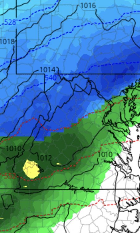
Donut Hole in Southern VA. Heading to RVA
-
Came home from work and we had a few drops of rain then it cleared out to a light cloud cover, could see the sun when the lower clouds raced by.
The squall in NC is producing a Severe Thunderstorm Warning with 70mph Gusts.
-
2nd round of storms seem to be speeding up faster than we thought
-
Sun peeking out at RIC
-
Clouds seem to be thinning out at RIC
-
Tornado Warning is now a Severe Warning.
Satellite is showing decreasing cloud coverage in NC/SW VA
-
1 minute ago, mappy said:
rotation looked good when the warning was first issued, its weakened a bit.
Yeah, low top and quick spin up
-
 2
2
-
-
1 minute ago, NorthArlington101 said:
TW NW of Wakefield, VA
Heading my way.
-
Heavy downpour near RIC.
-
Just now, mappy said:
Farting Butterflies
Jump to navigationJump to searchFart like a butterfly and it stings like a bee?
-
AKQ late to the party?
-
Getting pretty warm in RVA. Cloud cover has increased. Had peaks of sun this morning for a few hours.
-
3 minutes ago, AfewUniversesBelowNormal said:
Things are trending exactly as I said they would. +PNA is dampened, too much NAO, but it's basing out of the AO. The ENSO subsurface is now trending away from El Nino. It looks like +PNA breaks down to a more mild Spring pattern already by day 15 on GFS ensembles. These stick, in my experience.
Sweet, maybe the whole subforum can cash out at once. What an exit.
-
 1
1
-
-
-
It's been fun this winter! Can't wait to see what storms we have coming up in Spring/Summer!! Tipping the hat to the northern part of the subforum
-
 2
2
-
-
Just now, kurtstack said:
e8 has a white dot over Ji's house.
Let's go with that one. Still has RIC in the blue. Love ya Ji
-
-
9 minutes ago, MD Snow said:
The coastal that is beginning to be advertised starting Friday night into Saturday should be monitored for a number of reasons. First, It could surprise some people along the northern tier into southern pa with some unexpected snow. See the 12k nam and cmc for reference. Second, it’s strength moving up the coast will impact our Sunday/Monday threat. The stronger it gets, the lower the heights and temps behind it and the colder our Monday storm becomes. I believe showme had a post this morning harping on the potential this had. Will be interesting to monitor. One way or the other we have a solid 10 day window with accumulating snow potential.
I can't wait to track this over the course of the next week. March storms seem to be the most fun.


Richmond Metro/Hampton Roads Discussion
in Mid Atlantic
Posted