mattb65
-
Posts
4,722 -
Joined
-
Last visited
Content Type
Profiles
Blogs
Forums
American Weather
Media Demo
Store
Gallery
Everything posted by mattb65
-
This is a pretty long read but I think it provides a more nuanced explanation for how the epidemic evolves in a newly hard hit area as shown in NY initially and more recently in Florida, Arizona, etc. In particular the discussion around "herd immunity threshold" which is another way of saying what is the natural amount of infection before the epidemic starts burning itself out. This is a variable number and is entirely dependent on what mitigation measures are in place to reduce R(t). In other words if we go back to no restrictions then the R(t) increases and the epidemic takes off again after getting contained. https://covid19-projections.com/estimating-true-infections/ From the article: "Looking at the data, we see that transmissions in many severely-impacted states began to slow down in July, despite no clear policy interventions. This is especially notable in states like Arizona, Florida, and Texas. While we believe that changes in human behavior and changes in policy (such as mask mandates and closing of bars/nightclubs) certainly contributed to the decrease in transmission, it seems unlikely that these were the primary drivers behind the decrease. We believe that many regions obtained a certain degree of temporary herd immunity after reaching 10-35% prevalence under the current conditions. We call this 10-35% threshold the effective herd immunity threshold, eHIT." "One thing to note is that original definition of the herd immunity threshold is derived from the basic reproduction number, R0, and assumes no intervention and no social distancing. Hence, by definition, the HIT of the SARS-CoV-2 virus remains unchanged over time, between 50-80%. But the effective herd immunity threshold (eHIT) in the context of COVID-19 is changing over time because the effective reproduction number, Rt, decreases as a result of society adjusting to the virus. That’s why we are seeing infections and cases plateau and decline after prevalence reaches 10-35% as people gain temporary immunity. A removal of current restrictions and interventions, as well as a loss of immunity over time, may cause this threshold to return to its original levels of 50-80%."
-
This virus is relentless and constantly waiting in the shadows to emerge if given even the slightest opportunity. Here in Hawaii we avoided the first wave but the second wave is upon us and our cases are rising the fastest of anywhere in the country. We were lucky to have started from a very low level of prevalence in the community but it's crazy how fast it can take off if left unchecked. The state has closed bars, pushed back school openings, pushed back plans to open tourism and now closed beaches and public parks. It's pretty disheartening. There's been a surge of hospitalizations that is rising quickly over the last week+. They are discussing another stay at home type order if we continue to have >50 cases a day on average but trying to implement as many measures that dont significantly impact businesses as they can before going further.
-
Multiple problems with this perspective. Free interstate travel intertwines every state, we are only as strong as our weakest link with this virus. Repeatedly the public health side of this federal response says one thing i.e. reopening guidelines, and the political side of the federal response says there opposite, i.e. LIBERATE, Reopen, etc. Many states and especially those with Republican governors decided to reopen due to political pressures rather than public health science. I don't absolve states from responsibility but big picture, our failure at containing this virus is unique in the developed world and I think the primary reason is the politicization and misinformation running rampant.
-
"LIBERATE" and reopen everything without following the gating criteria put out by the coronavirus task force. So many missteps. The federal response has been as bad as anyone could imagine, the federal response has literally sabotaged what could have otherwise gotten us on track. Being in an election year has probably made it worse.
-
From the articles discussion "Our findings may provide an indication of potentially considerable burden of inflammatory disease in large and growing parts of the population and urgently require confirmation in a larger cohort. Although the long-term health effects of these findings cannot yet be determined, several of the abnormalities described have been previously related to worse outcome in inflammatory cardiomyopathies.2" It's definitely a concern and all the more reason to do whatever is feasible to put measures in place to contain the virus like every other developed country in the world. With vaccine data continuing to be promising it is incredibly foolish to continue to fail as a country at following the successful playbook we've seen done time and again around the world by the other developed countries.
-
MD here, this information is readily available in table 1 of the study. There were two control groups to compare against the covid patients. Of 50 healthy controls, 3% had evidence of myocardial changes, of 57 risk factor matched controls, 40% had evidence of myocardial changes at baseline. Active inflammation is measured by T2 signal, 60% of Covid patients had active inflammation, 9% of risk factor matched controls. Also important to note, these MRIs were done approximately 2-3 months after infection. Reasonable conclusion would be that covid causes a significant increase in myocardial inflammation that persists for at least 2 months after infection.
-
MLB did plan, they have a "taxi squad" to fill in for players that go down because of the virus. They are testing repeatedly to try and catch cases before they turn into an outbreak. The nature of this virus just makes team sports incredibly difficult to accomplish. The locker room is just too risky for easy spread, it's really unfortunate. Plus with teams flying around the country there's too many opportunities for a player or other employees to catch the virus and accidentally introduce it into the clubhouse.
-
Also, it appears that the number of cases, percent positive rate nationally are leveling off. Some of the hard hit states like Texas and Arizona are seeing their hospitalization numbers leveling off or starting to decline. Hopefully we see a longer term steady decline compared with the last time when things just got reopened recklessly and we had the big surge. The cases leveling off will hopefully help ease the testing shortages that have been impacting test results coming back in a timely enough manner. How the numbers change once K-12 schools and especially universities reopen to in person instruction will be the next stress test on containment in my opinion.
-
42.4% of American adults are obese. Nearly 50% of men aged 40-59 are obese. You wouldn't have much of an economy with your ridiculous and unconstitutional, not to mention impossible plan. https://www.cdc.gov/nchs/products/databriefs/db360.htm#:~:text=The age-adjusted prevalence of obesity among U.S. adults was,adults aged 60 and over.
-
They have turned the curve and started to see cases decline. Measures of success that their business closures, mask mandates and changed behaviors are working. Their hospitalizations have flattened and their percent positive is starting to go down this week.
-
Before the numbers hit in this recent spike there was some hope that we had knocked the infection fatality rate significantly. Unfortunately I think it was the second hand spread from the young people to the at risk population that was inevitable with out of control spread shows that we are only doing marginally better than before. I had previously posted on the other thread before it closes down that I didn't think we'd get back up to over 1000 deaths per day on the 7 day moving average unless something went horribly wrong. Unfortunately there are now reputable models predicting that we get there in the next month. It's really unfortunate how badly things have gone.
-
I would be surprised if one of the big European countries has a big flare up like we are seeing here. They have done a much better job staying closed until their case numbers were very low and then opening up really slowly. They have criteria in place to slow down or take steps backwards if needed. Here the plan in Texas, Arizona and Florida was yolo, lets open everything and hope it works out. Now the plan is oh shit.
-
More than half the country have a high risk comorbidity, 40% alone are obese. This is not a realistic idea.
-
What don't you get about the hospitals being overwhelmed? Part of it is to prevent as many deaths as possible but a big part is also because the virus causes lots of people of many ages to get sick enough that they need hospitalization, and when it goes unchecked it spreads insanely fast. The ability to grow exponentially and fill up hospitals and ICUs is this viruses super power. It is the reason you can't just pretend it doesn't exist. Your obviously need to be smart about how you contain it, the EU is providing some good models for how to do it, same with some states in the northeast. Or country is either too arrogant or too stupid to follow the science. Messing up on containing the virus looks to be heading toward renewed shutdowns in FL and TX unless things turn around in the next few weeks. It'll have to happen to about crisis care.
-
He's part of the big second wave of cases that our country is experiencing. I know, lol cases - you've posted that a couple times. Pull up the cases chart for Ohio and he's in this second wave. You haven't posted "lol cases" recently since the deaths have spiked which occurred right as they were predicted to spike all around the south and southwest and increasingly in other places. The story I shared is the prototypical second wave case, young person who mocks the virus and any restrictions to slow down the spread and catches it and dies. This is an American problem and I think it has a lot to do with our political situation here. I haven't heard of these types of situations coming out of Europe. Here's another one from San Antonio https://www.nbcdfw.com/news/local/texas-news/san-antonio-patient-dies-after-attending-covid-party-doctor-says/2404937/ If Phineas were in here in know he'd have a meltdown about how the virus kills mostly elderly and how the media amplifies these young person cases to stoke fears. It's true, young people usually get through this disease and most are asymptomatic or minimally symptomatic spreaders - which is also a dangerous part of this pandemic - but there are a bunch that will get severe covid and end up with serious lung and other organs damage, and a bunch that will die. Since the majority of cases has shifted younger, the deaths aren't rising as dramatically as NYC, thank God, but there are many more young people in these ICUs now, that's being reported in a bunch of places. It's critical for young people to avoid this selfish mindset of invincibility and purposefully or inadvertently creating super spreading events with covid parties or bar crawls or similar. These are the events that give jet fuel to the epidemic and create case and subsequent hospitalization surges.
-
Some sad stories like this coming out of the hard hit states. https://www.truthorfiction.com/richard-rose-dies-of-covid-19-after-repeated-covid-denier-posts/
-
Pretty crazy to see the numbers this high. Today was also a huge testing day, 823k tests, over 100k more than last week so still a slight rise in % positive but some of the big jump in cases can be attributed to the number of tests today. Also new today, Florida is finally reporting covid hospitalization numbers, their 7,000 are 3rd behind Texas which crossed 10k hospitalizations and California which is up to nearly 7,900.
-
I think we definitely have over 100k, models like the yyg estimate that we are probably at 4-5x the number reported right now. Back in March it was probably 10-12x. Current estimate is 250k-260k new cases per day in the US right now. We are very close to the estimated daily number of cases from the peak in the first wave. Thank God it is in younger people this time and that medical providers and treatments have improved. The other problem aside from processing time is that once you start to see shortages in testing capacity, tests start to be rationed again to the high risk and hospitalized. Also the data becomes much less useful from a public health case identification/isolation/contact tracing perspective. We are fully back to mitigation only method to contain the outbreak in most places seeing fast rising cases.
-
The one silver lining that I see it's that the rate of rise in cases appears to be slowing down, only 4000 more than last week. It had been increasing by 10k+ every week. Testing volume has been pretty stable over the last week
-
Yeah, pretty bad, unfortunately it's pretty clear to me that there is a surge in deaths hitting these states, the numbers this week are all bad. I do have hope that these states will flatten out in the coming weeks. It's sad to see this happening, this was all predicted by the health experts. I was worried about it in late April - Georgia reopened and didn't surge because people were being very cautious which created a false sense of security so people decided to cut loose and let their guards down. Surges like this threaten everything - the ability for the economy to recover, the ability for schools to successfully reopen and stay open. How many times do we as a country need to learn the hard lessons that we need to respect the biology of this virus in order to live with it while we wait for an adequate vaccine, treatment or preventive. Dr. Fauci hit the nail on the head today when he highlighted the transmissibility as one of the major factors that sets this virus apart. The severity can be debated, I can see how some will minimize a death rate of 0.6% or wherever it ends up. But no one can deny the incredible ability this virus has to very quickly and dramatically fill up hospitals and ICUs like nothing we have ever seen in our lifetimes.
-
The big data dump appeared to be yesterday when the numbers were close to 1,000. I didn't think there would be another big data dump to carry over into today. The only big anomaly that I see is the big number out of New Jersey. But I agree, 2 days of significant rises compared with prior weeks is too soon to call it a definite spike, need to see what happens the rest of the week.
-
The numbers look bad again today. Definitely looks like deaths are spiking in Texas and possibly California. Lots of places appear to be seeing a rise.
-
Not sure how you can say that when looking at the hospitalization curve I just posted from Texas. Their deaths have also starting to rise steeply, same with AZ and FL
-
Yeah, today's excess is basically the significant decline we saw in Friday due to July 3rd holiday carried forward to today. On Friday there were 247 fewer deaths than the previous Friday.
-
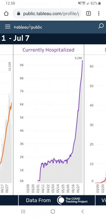
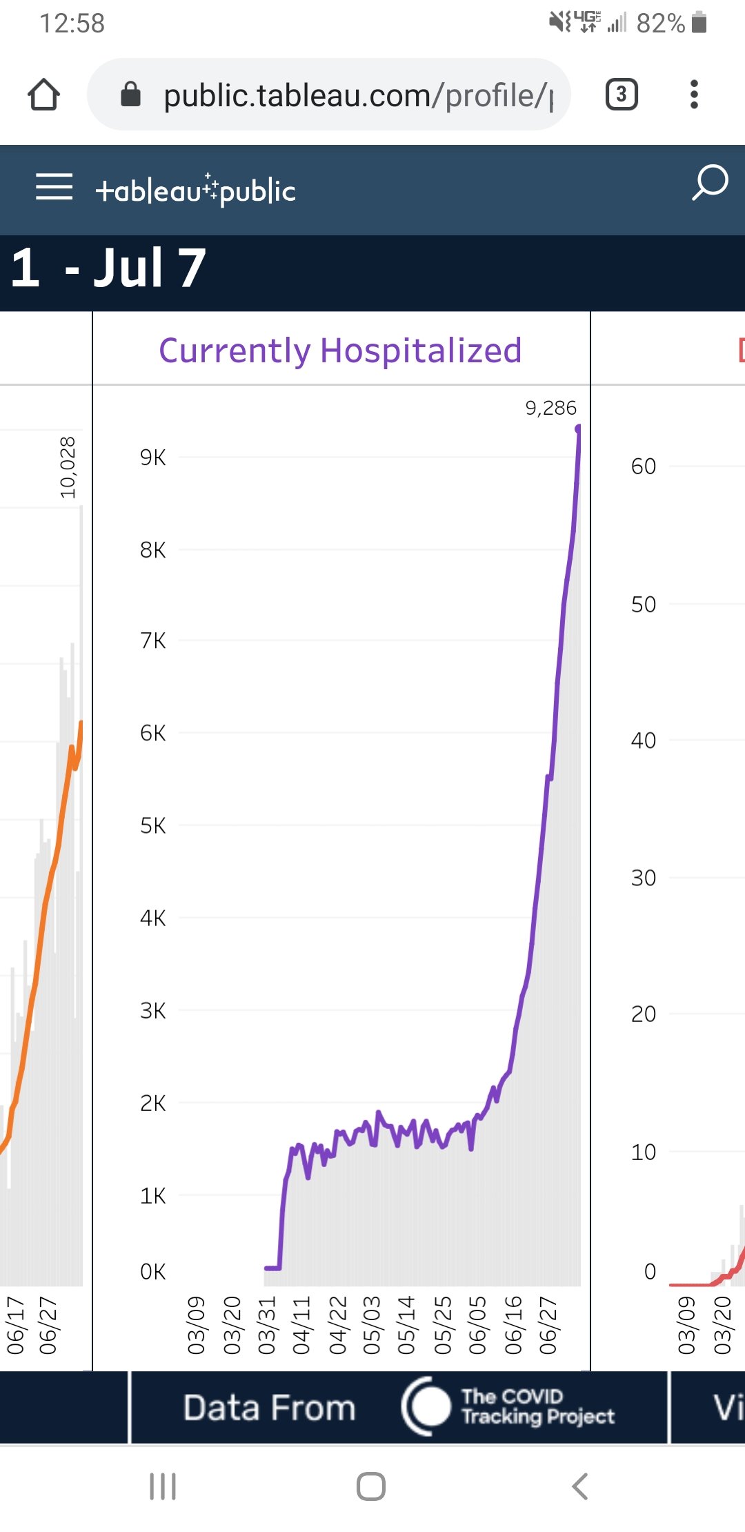
They may be floating the available beds by cancelling elective procedures but that'll only work for so long with a curve that looks like this. This is Texas. They have been doubling hospitalizations every 12 days since June 11th. If that pace continues they'll be at 16,000 hospitalizations by July 16th. That pace will definitely overwhelm local capacity quickly. Hopefully with the measures put in place last week, that doubling rate will slow significantly so that some of the current hospitalizations can start getting discharged to flatten out the hospitalization curve.