MAG5035
-
Posts
5,718 -
Joined
-
Last visited
Content Type
Profiles
Blogs
Forums
American Weather
Media Demo
Store
Gallery
Everything posted by MAG5035
-
Well I did my part to reel this storm back in. Snow tires are scheduled to get swapped off my car tomorrow for the regular ones. As much as I like tracking a good snowstorm, I'm def ready for things to break. But this is quite the cold, unsettled pattern whether we get another snow or not. Realistic chance that after we saw 75-80ºF+ in February we may not see it again til it's May.
-
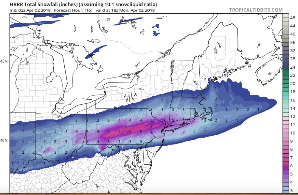
NAM 2m temps are in the mid-upper 20s while this is ongoing. Kuchera takes the warmest temp in the 500mb-surface part of the column and applies it to an equation to spit out the ratio.. so in this case the warmest temps would be at the surface and those kinds of temperatures with a spring storm is impressive. Even more impressive is the NAM's 850 temperatures.. at -6 to -10ºC in the region of C-PA where it's snowing.. in APRIL. That's also why the precip shield might have tightened up in this run.. this isn't no marginal sloppy wet snow look that's for sure. For instance the NAM has Harrisburg at 28-29ºF during the best precip (that's during the day mind you). Applying Kuchera to roughly -2ºC or 271K gives a ratio of 12:1. We've also seen in the last two events ratios that are greater than 10:1 even with having marginal at or near freezing surface temperatures. One has to remember the lifting processes that initiate snow growth go on higher up in the atmosphere, which is a bit of a drawback of the Kuchera. That method doesn't apply that stuff, which is why I don't like using it in marginal temp situations (with that said this does not looks like a marginal temp situation haha). If the rates are good and accumulations are established on the ground, you can get fluff bombed by the good flakes that pile up quickly even with marginal temps.
-
With the Saturday event, the CMC is farther north with precip coverage and snow axis than the GFS is. The GFS brushes the PA/MD border with some accumulating snow but the axis of heaviest is through WV/MD/Northern VA/DC. A lot of the GFS accums come from that Tuesday one that it has, while the CMC's mostly comes from Saturday's storm (doesn't impact us with the second storm system). I'd concentrate on one storm at a time and specifically that Sat system for the potential to trend north into PA with possible impacts. Sidenote: While we're discussing/chasing our next prospective April snowfall.. there was some half decent thunderstorms that came through here earlier tonight.
-
So that's pretty much 10 advisory or greater April events for H-Burg in the last 124 years (8% or 1 every 12.4 years). This pattern we're in gives a legitimate chance at 2 such events in the same year.
-
This mornings event seems like it quietly ended up targeting our folks "living on the fringes"... with 5-7" reports being pretty common around the Centre region (State College and surrounding), 4-5" where 2001kx is and the same around IPT where the climo station there reported 4.6" this morning. It seems the more robust high res NAM/HRRR amounts and somewhat further north placement of the heavy snow axis won the day.
-
Well not sure on an actual storm per say, but it looks to be a pretty robust shot of cold air coming in for the weekend. The potential weekend storm looks to be south currently, although the GFS eventually has a following system at the beginning of next week that appears to be snow producing. Details aside, certainly the moral of the story is that this pattern for at least the next 8-14 days is no where near a sustained springtime pattern.. and the potential is there within that pattern to produce yet another type of event like what just happened this morning. So we'll have to keep watching. Back on the weekend, there looks to be a frontal passage Fri-Fri night bringing in pretty impressive cold (for April). Low level lapses are progged to be pretty impressive, as you would figure on with the strong April sun and surface warming. Could be lots of snow showers/squalls around or even some kind of organized line of such things with the frontal passage. That might be what the models are trying to portray with the QPF across the state in that timeframe (roughly between 102-114).
-
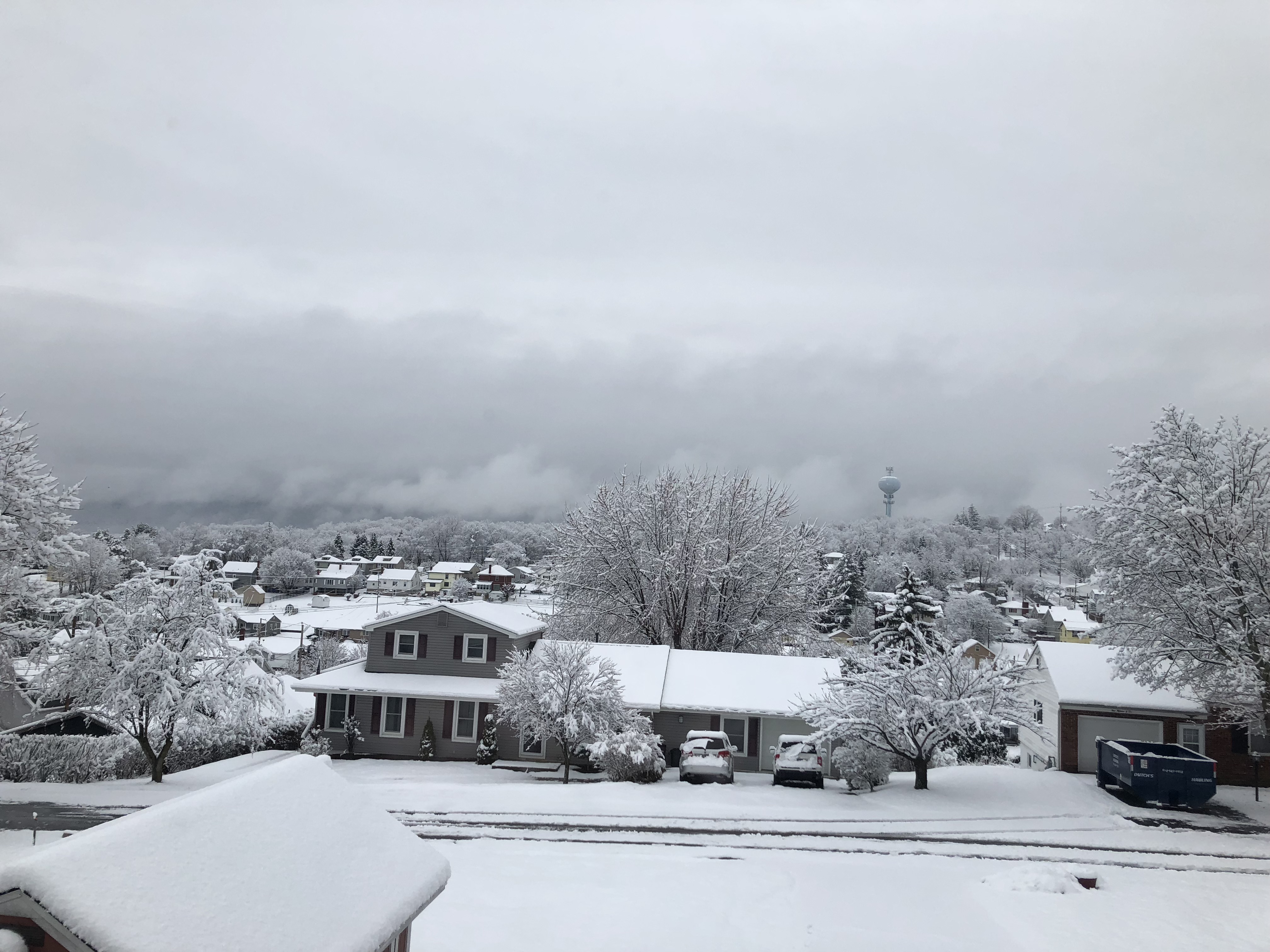
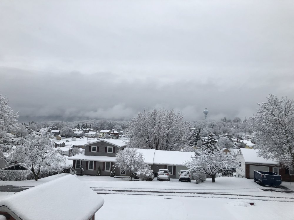
Went out to measure a bit ago and got 4.7" again so using that as the storm total here. That brings my seasonal total to 54.6", where 50-55" is roughly an average winter around here. Def a very impressive close out of winter (23.4" since March 1), as entering March getting to average was looking like a long shot.
-
Just measured 4.7" and moderate snow ongoing. It's a heavy wet snow that's caked on everything.
-
Continuing to pound snow outside... now past 2.5" and the streets are covered now as well. Looks pretty good up there, some of the 511pa cams are showing Atherton St starting to get covered.
-
Heavy snow... past an inch already. Paved stuff still mostly wet.
-
Well that didn't take long... Heavy snow and starting to accumulate (dusting)
-
Precip starting here, looks to be mostly or all snow. Need to work on temps a bit (39ish) but they should wet bulb down pretty directly as the rates go up. Judging by radar trends and latest full HRRR (02z) I think the State College region is going to be in this one pretty comfortably. HRRR in fact suggests State College to be close to the heavy snow axis. Probably would knock an inch or two off of the high end but we'll see how well things accumulate once precip gets heavier. This event is certainly warmer temp wise than the last one, both on ground temps and surface temps.. so that's a potential limiter. On the other hand however... this is coming at night, and I would imagine from a pure snow growth standpoint that ratios of >10:1 are certainly achievable. Should be fun to watch, this will be a quick and hard hitting event.
-
Well it does seem models overall are a bit north today on the 12z suite. The meso models (NAM, RGEM, etc) certainly didn't fringe out UNV or IPT and are overall pretty robust on snow amounts. Looks like a quick and hard hitting type event. Timing is also good for accumulations as this event looks like a night one for a change.
-
Before you doze off for the Spring and Summer slap a Central PA on the Spring 2018 thread title. Although it doesn't look like you'll be hibernating quite yet with the look of the pattern haha. Even if it's brief we usually see our first warm stretch of the Spring in the first half of April but man there looks to be no such thing on the computer models. It didn't even look that wintry for most of February.
-
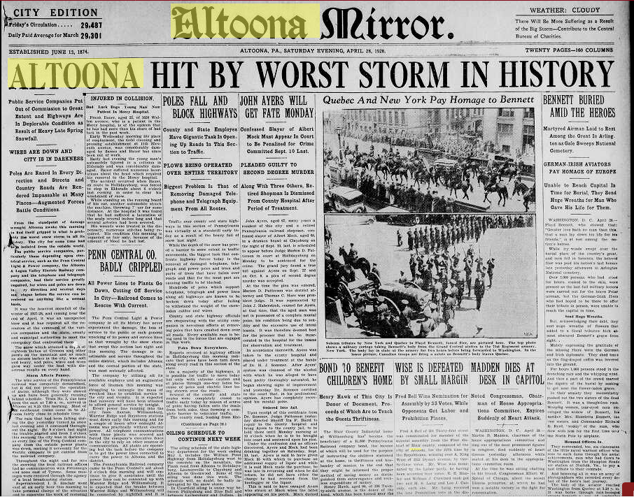
That April 27/28th, 1928 event delivered around 18 inches of snow to State College and Altoona. Couldn't even imagine getting a storm like that so late.
-
Devastating tornado strikes Joplin, Missouri
MAG5035 replied to Hoosier's topic in Weather Forecasting and Discussion
Also, if you go back to the 2nd page of this thread (post 45) you find a poster that quoted JoMo's last few posts before the storm hit.. the second of which saying about the sirens going off. TIme on that post was 5:17 CDT, right at the time of the warning (VTEC31) issuance. 10 minutes later was his last post about the couplet being nearly overhead. Whatever happened to that particular thread (or portion of this thread) where people were posting as the storm was unfolding? I seem to remember that folks might've been watching that first warned cell when the Joplin cell suddenly exploded into the monster tornado signature just outside of town. There's of course those couple chaser videos that show this tornado going from a developing multiple vortice to a massive wedge in about the time it takes for the doppler to make one scan. I know that's one of the many aspects of this storm that fascinates me..practically watching the whole wall cloud drop to the ground in a minute or two. -
Devastating tornado strikes Joplin, Missouri
MAG5035 replied to Hoosier's topic in Weather Forecasting and Discussion
Very glad to hear that you and your family are ok.