MAG5035
-
Posts
5,718 -
Joined
-
Last visited
Content Type
Profiles
Blogs
Forums
American Weather
Media Demo
Store
Gallery
Everything posted by MAG5035
-
Central PA - Jan/Feb 2019 Obs and Discussion
MAG5035 replied to MAG5035's topic in Upstate New York/Pennsylvania
This opening salvo of snowfall is pretty impressive in the Altoona-Bedford-Mount Union-Huntingdon region, heading for State College. Already a coating on all surfaces including the streets and large aggregates. -
Central PA - Jan/Feb 2019 Obs and Discussion
MAG5035 replied to MAG5035's topic in Upstate New York/Pennsylvania
Snow has begun here. 32ºF -
Guys I just started a fresh thread for this storm since we're at about 2500 posts in here. If this storm flops and we don't end up a ton of postings on it than I will just rename to be a new general discussion thread after the storm.
-
Central PA - Jan/Feb 2019 Obs and Discussion
MAG5035 posted a topic in Upstate New York/Pennsylvania
Cloudy with temps around 32ºF, some freezing drizzle falling. -
Well, did not like that final bump from the guidance this morning.. esp from the NAM. That's no bueno for the Pit Metro and our far southern tier gang. Everything's pretty much in agreement now and the surface low enters SW PA and runs southern PA instead of staying just south.. and that has the biggest implications in Pittsburgh and also south and east of H-burg with respect to higher snow totals. That track would also shift the deform snow axis NW to the northern tier and NW PA so the central locations are going to have to get there mostly on front end snow. That might spoil AOO and UNV's bid at 10 or more. But HRRR continues to look good for that general area you mention with those locations. I guess the good thing with that lousy track is that central is going to get slotted before it mixes for too long. If I were to make a call for the Harrisburg region, I think at least 4-5 is still pretty doable, and York/Lancaster region can still pick up 1-2".
-
Yea here in Altoona it could go either way. 6-8" is probably still a good bet and if there's not a lot of mixing then a foot or so is certainly doable. I think UNV gets to 10". I had a post earlier today mentioning if that happened I believe would be the first winter they've had 2 or more 10"+ single events since 95-96. We got whacked by the November storm in this region under similar circumstances. I think the original warning was for like 4-7 and I had about 9 inches before it even mixed (on the way to 10.5") and State College had almost a foot. The damage was done on the front end of that one and it just poured snow for a few hours in the afternoon. This one is similar but stronger, more moisture laden and perhaps a bit further north. November's storm didn't have a closed 850 low and this one does which with the track of that into SW PA is the primary sticking point with this system. On the other hand we're deep into January and in the coldest stretch climo wise, there's a significant arctic air mass to the north that while not being fully tapped will likely anchor some CAD. I just don't think we're raining nearly to Williamsport on the GFS's track. (maybe if the super amped RGEM and HRDPS had its way). I don't think I've ever seen CTP bet the house on totals like this given uncertainty, esp in between the turnpike and I-80. It's going to be an interesting day tomorrow.
-
Lol, that's a tough place for snow, especially under I-70. At least Pittsburgh metro rides the line a lot more often with these type of events.. and looks to do so again tomorrow. The low ultimately should stay under PA, so I think Pittsburgh should be good for at least 3-6". With how the low is tracking you guys may see some accumulations when the cold air changes things back over on the back side.
-
That sounds like that would be a big cities thing, where the rain/snow line set up on the wrong side of I-95.
-
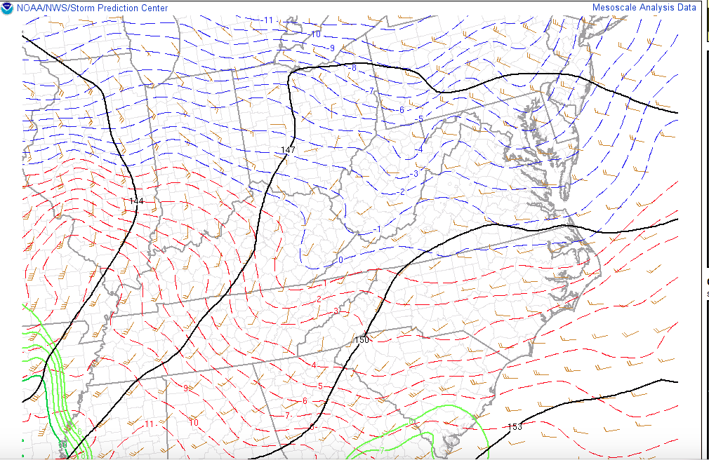
I'm sure cloud cover is holding temps up a bit at the surface, but aloft the 925mb and 850mb temps are easily below 0ºC right now. The 850mb 0 line is running along southern VA right now per mesoanalysis. If surface temps are near or a tad above freezing at precip onset tomorrow they'll likely drop back some. In the far southern tier it may start as something else briefly until heavier precip cools the column all the way down. Onset of this isn't looking like it's till early afternoon in the Sus Valley.

-
Looked like mostly snow and a few hours of sleet to help anchor the pack, I think i'd sign up for that.
-
Lol, I actually don't think his map looks bad, but it looks like he was trying to scribble out the SNE gang with his 4 and 8 inch lines. My local nitpick with it is if we actually get 12-16", that means there was little or no mixing. I think AOO-UNV corridor is in the 6-10" range if we get a more extensive wintry mix period. I doubt we get a foot plus AND a significant ice storm.
-
12-16 AND ice storm possible? How'd I get so lucky haha. A few quick comments on the longer term before we get fully into this storm. It really looks to continue to be active and there is some serious arctic air on the table down the road. We do look to lose a cutter midweek but that sets the boundary for a secondary storm. 18z GFS for example had a snowstorm for a good section of the subforum while the Euro didn't press the boundary and phased up a <975mb low through the heart of PA. Other runs had the system completely SE of our region. So needless to say that looks like that may be our next headache. The day 8-10 Euro like last night unloads a major arctic air mass Lakes and NE with less than -30ºC 850 air over all of PA via a massive western/AK ridge bridged over the top to a major ridge SW of Greenland. -30ºC at 850 in PA is serious stuff if it came to fruition. That is Jan '94 cold outbreak variety. A lot of things to watch when we get past this impending storm.
-
Updated CTP short term:
-
Before I forget I did end up with about a 1.5" total from last night. Yard snow depth was about 3.5-4" this morning which might have shrunk a little bit. But it's been an overcast and sometimes hazy/foggy day around here and temps have managed to creep up to around 34-35ºF ish.
-
Here was my post from the previous page. I don't think there's anything being particularly missed with model analysis, I mean it is right there on the major models where they warm things aloft for mixing over southern parts.. but most have front end snows. I'll live or die with this but with the 12z GFS track it is NOT raining to Williamsport with this as it depicted. I do think as stated above that this will be a fairly fast and very hard hitting system that could deliver warning totals to the LSV up front before mixing, which could be where CTP is going with that. I dunno about 8-12" in H-burg but 6" isn't out of the question before mixing. There's likely to be pretty intense lifting to go with the front end heavy snowfall in a large part of the column, which could bolster ratios some (kuchera doesn't account for that). Even just a 12-14:1 type snowfall would pile up pretty fast. I also disagree that it is a marginal setup. Marginal would be if it's in the 20s across the border in Quebec with not much high pressure. It's to be in the MINUS 20s to -30s up there. Strength in the high pressure in mb is not necessarily as important as the pressure gradient between a mid-upper 1030s high vs the approaching 990s low from the OH Valley. Air flows from high pressure to low pressure. Thus I think low level cold is being understated some with bleeding down from the north. The only thing marginal is the track of the 850mb low being a bit NW of where we'd want it... but otherwise this arctic air to the north is enough to force the storm mostly underneath us. But yea I am surprised their numbers are that high, although I expected warnings for the whole area. I was anticipating more mixing and somewhat lower totals. One thing I don't expect this to be is an extended rainstorm, even in the far southern tier. I think we all see varying degrees of a front end thump.
-
Wow 12-16" in the warning grouping for here. 10-16" on the northern counties. I'm very intrigued as to why CTP has been especially adamant on this being dominant on the frozen end. The 12z guidance today hasn't exactly instilled any confidence in me making a call for 10+ in the AOO/UNV corridor although warning snows are definitely likely. They could be taking precip intensity into account as this looks to be a fairly fast and very hard hitting storm in that department.. much like our November storm. That one overachieved in the LSV before mixing. Intense precip would keep an isothermal column for awhile when the warm air aloft tries to push in. They also could simply be factoring in climo too. This is the coldest time of the year, and we have arctic air to our north which should bleed in at the low levels to some degree as this storm approaches. This is hardly a frigid storm setup but it isn't necessarily a marginal one either.
-
I'm not sure how 12z UKMET fared yet vs 0z via meteocentre models. It appears to be faster and does breach the southern half of PA with 850mb temps at or above 0ºC. But I'm not sure if the 0z UKMET did that because it was slower and the warmest frame would have been after 48hr where it goes to 12 hour increments.
-
I'm pretty sure at least from looking at some of the KPSU observation archives that if the State College area were to see 10"+ from this storm that it would be the first time since the 95-96 winter for having multiple 10"+ events. Not even 02-03, 03-04, or 09-10 had that there (only 1 per winter). It doesn't happen too often even in the snowier winters. I try to clear off after things mix/change over and put salt down, and usually that'll make any sleet/ice easier to remove. Especially if there ends up being a good bit of sleet.. sometimes that's worse than having a crusty top to the snow. That or leave whatever snow is there til the event's over but with the possibility of a rapid refreeze that might not be the best idea for this scenario.
-
Measured at the 1 inch mark outside with a nice steady light to moderate fluffy snow. Temp 27ºF. Also went into the yard and got an overall snow depth since I had snow left from last weeks lake effect and fringe snow from the DC special. That's at around 3.5" with tonight's snowfall so far.
-
Back to moderate snow and some nice sized flakes.
-
It sure is. I don't split hairs or isobars with pointing out very subtle run to run shifts. This is a pretty big shift back in the right direction with the mix line running the far southern tier under the turnpike but getting no further north in the LSV.
-
NAM at 45hr is decidedly south of 18z, with a low center on the southeastern KY/TN line vs 18z positioning near Louisville, KY
-
How were 18z GFS ensembles snow wise? I love Accupro's expanded stuff with model data but their ensemble section leaves a lot to be desired. At any rate it looked like it was a bit colder vs the means at 12z.
-
I'm also at 0.6", with round 2 just about here.
-
Haha well still gotta get to the finish line. I am concerned about mixing taking the top end off of accumulations in the AOO-UNV corridor. Confident on getting to 6" but we'll see about double digits. November's storm was somewhat similar, mixing was supposed take over.. which eventually did but it stayed mainly a snow/sleet mix and we got to 10.5". In that one the damage had been done on the front end anyways, where I had over 3 inches in an hour at the height. This storm could/should have similar intense precip.