MAG5035
-
Posts
6,074 -
Joined
-
Last visited
Content Type
Profiles
Blogs
Forums
American Weather
Media Demo
Store
Gallery
Everything posted by MAG5035
-
This next batch of torrential downpours is here. The elevated instability is definitely present as there's been several cloud to ground strikes.
-
Maybe we'll have actual winter weather and snow chances in December for a change if some of these rumblings about an eventual Nina come to fruition. Most CPC guidance is pointed generally neutral but the CFS v2 has been solidly in nina territory later this year. Just a little bit of time to hone that one in haha.
-
Can’t relate on the underachieving rainfall. Just got crushed with a torrential downpour with some thunder. Lots of standing water in the yard and one of the underground drains at the bottom of the yard was erupting like a geyser. First time I’ve seen that since I moved here a few years ago. It must have been fairly rainy earlier this morning. @canderson I hope your family member is doing better.

-
QPF aside, the two systems would have been likely examples of systems we would have all scored from had this occurred in the dead of winter. The pattern setup is just enough to finally run a couple systems under us but we need significant anomalous cold (compared to March climo) to go with that this time of the year which we don't have.
-
So this is happening about 10 miles from here... and probably at the top of the mountain 4 miles from here as well. It's raining here. Might see stuff like this further up in central and north central at similar elevations.
-
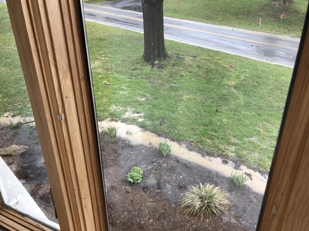
Have had some precip falling for a little while, looks to be mostly or all rain.
-
I don't think this storm is necessarily a loss track-wise, the main issue is what I mentioned the other day about precip intensity vs very marginal temperatures. Although, I suppose a bump NW with this initial shield of WAA precip doesn't help with the earlier portion of this event where the best chance for initial snowfall is.. esp central and SE. It's chilly and quite dry in front of this system, like last week. The snow potential on the lead up this week was certainly viable.. If we had a solid slug of moderate to heavy precip targeting the region late tonight into tomorrow morning, most of us would likely be receiving an accumulating wet snowfall. The problem is a separation from the initial precip which seems destined more toward the north central and the blossoming precip associated with the developing coastal low. Timing of the latter is later tomorrow, when the strong high (which doesn't have extremely cold air to be tapped anyways) is off to the east and the delay in the onset of more decent precip allows for daytime warming of the already highly marginal low level temps. Thus, we still have a viable snow threat in the north central region (esp at higher elevations) where this initial wave of precip will impact the most and where it will remain just barely cold enough as the coastal takes over. Unfortunately for the central and Sus Valley, whatever potential flakes may be seen is going to be dependent on if we can develop a band of WAA precip. Early looks at the HRRR haven't been too enthused about that. The radar looks okay (much better for the north central eventually) but one has to be mindful of the dry air in place. Just another case of close but not enough... fundamentally the same problems are still there. I still think the continued +AO coupled with the quietly persistent -PNA is outdoing what the recently turned negative EPO regime could have done for our region without that counterbalance. The AO is at nearly +5 right now, and the pattern alignment over the CONUS favoring eastern ridging at 500mb won't allow for this system to really amp. The EPO may have helped enough to finally get something under us, but we're not cold enough...and we're way late in the season to rely on marginal. The system later this week may well take about the same track as tomorrow's system, but it doesn't appear that it will have enough cold to work with outside of the higher north central.
-
Models and ensembles are still generally supportive of this snow threat on Monday, which I think could be in the cards for most in here. The Euro still leads the way but has edged down accums and shifted north a tad. Some of the runs this week on that model were looking March/November 2018 worthy. Obviously the elevated central and north central parts of the state stand the best chance of seeing any kind of decent accumulations, but we could see accumulating potential even in the Sus Valley. Surface temps are going to be very marginal and it seems that timing is heading towards most of this event being in the daytime though, especially east. I think the biggest thing I see from the models is the snow potential appears to be rate driven. The column temps are there enough if we have a wave of heavier precipitation, and we're going to need a several hour burst of heavy precip to realize any white on the ground with the surface temps.
-
I had a light coating on the grass and cold surfaces, 0.2” ish. It was snowing decent for a little while last night. It seemed just a couple hundred feet of elevation made the difference between that and a half inch to an inch here off the Laurels, and once below about 1100-1200’ (I’m at about 1300’) there was little to no accum. The Allegheny Front is white of course, I didn’t get a chance to run up and see how much was up there.
-
Me too lol, I haven't gotten to put mine out since I made it.
-
I don't know if much of tonight's wave makes it very far east of the mountains, but from I-99/US 220 below I-80 westward into the Laurel's region this is starting to look like a surprise event considering what CTP has in their winter products at the moment compared to the models today. Early HRRR looks into this event are pretty robust, with more northern extent than the NAM and high end advisory snow amounts Cambria/Somerset (Laurels). Models are generally supportive of that region (and even into the surrounding counties) seeing potentially an advisory event "on paper". Temps are warm today obviously, but dew points are very low.. so I don't think getting a timely changeover will be hard once the heavier precip moves in. Given how warm it has been and virtually no preceding or entrenched true cold, this is going to be very springlike and play out more like an early April type wave.. with accums mostly on the grassy surfaces and it might take awhile to actually get anything going on the ground. But timing of this thing overnight is going to help. I think any road issues that pop up will be reserved for the higher Laurel's. Somerset County looks to be the PA place to be for this, and I wouldn't be surprised if parts of that county sees close to the amount the short term guidance is putting out snow wise. I don't think the precip makes it past the the mountains to the Sus Valley heavy enough to make for any accums, even if it does actually mix or changeover. Will have to see how the swath tracks, as it could run the turnpike or perhaps make it a bit further north as the HRRR is suggesting. A decent amount of guidance says I get my biggest snowfall of the season tonight, we'll see lol.
-
Haha it’s okay. My biggest single event this year was 2.1” back in Jan, of which like an inch of that was actually sleet. I’ve never seen a winter like that here, the bad ones always have at least one half decent event. The only reason I have 15.5” is being right at the foot of the Laurels and getting several inch or less type snows. The airport 15 miles SE of Altoona (KAOO) I think has like 5” for the season. We could get whatever large snowstorm from here out in the next few weeks but it isn’t going to change that stretch of futility. I almost hope that we don’t see anything notable til next winter. Because this winter has pretty much demonstrated what a truly bad one looks like.
-
I'm bringing this over here. Yea i was reading some of that last night and this morning, which continued over to their banter. I've noticed it seems the forums have been moderated less the last couple winters.. which is fine in some respects as there's no need to get super strict on being on topic or some banter scattered here and there, even in the busier threads (this one is small enough that usually banter isn't an issue). But a couple of those folks down there need 5 posted or banned as it's been reading maybe slightly better than your run of the mill facebook news comment section.
-
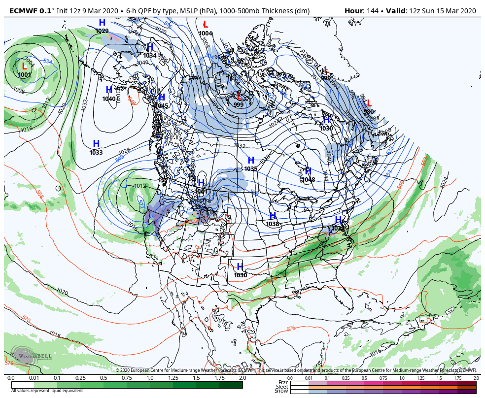
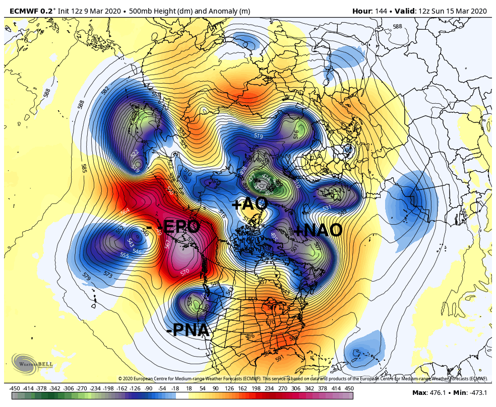
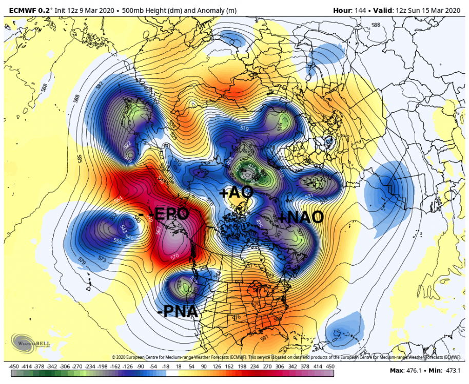
This new thread should hold us over for awhile. I'm starting to feel like a broken record, but until the AO breaks down we are going to remain in the same general pattern we've had largely the last 2 months. The major downturn of the EPO in the progs does offer up a potential winter opportunity later this coming weekend as the monster East Pac into AK ridge (-EPO) tries to press the cold via a very strong high tracking to the north. Again, this +AO regime up over the pole is mitigating what such a negative EPO could potentially do. Another issue is the trough dumping into the west coast (-PNA) It does appear to be enough to suppress the storm track in the case of this storm next week but there doesn't appear to much opportunity for the wave being progged to deepen much. If we didn't have the continued low heights over the pole, we would be probably talking a major period of cold for March incoming with how negative the EPO is forecast to go. Here's todays Euro at H144, first the surface and then the 500mb.. and you can see what this +AO (and -PNA) does despite the monster -EPO. But you can also see that the -EPO tries to press the cold into the northern US despite a 500mb look that doesn't look anything of the sort. It also shows this wave doesn't have much opportunity for amplification. So while we may time this really strong high (1048 in the case of today's Euro) with a wave to get wintry precip. It may not be much, or even suppressed.

-
Devastating tornado strikes Joplin, Missouri
MAG5035 replied to Hoosier's topic in Weather Forecasting and Discussion
Also, if you go back to the 2nd page of this thread (post 45) you find a poster that quoted JoMo's last few posts before the storm hit.. the second of which saying about the sirens going off. TIme on that post was 5:17 CDT, right at the time of the warning (VTEC31) issuance. 10 minutes later was his last post about the couplet being nearly overhead. Whatever happened to that particular thread (or portion of this thread) where people were posting as the storm was unfolding? I seem to remember that folks might've been watching that first warned cell when the Joplin cell suddenly exploded into the monster tornado signature just outside of town. There's of course those couple chaser videos that show this tornado going from a developing multiple vortice to a massive wedge in about the time it takes for the doppler to make one scan. I know that's one of the many aspects of this storm that fascinates me..practically watching the whole wall cloud drop to the ground in a minute or two. -
Devastating tornado strikes Joplin, Missouri
MAG5035 replied to Hoosier's topic in Weather Forecasting and Discussion
Very glad to hear that you and your family are ok.