

BooneWX
-
Posts
3,578 -
Joined
-
Last visited
Content Type
Profiles
Blogs
Forums
American Weather
Media Demo
Store
Gallery
Everything posted by BooneWX
-
I by no means am wishing for an ice storm but that has been an interesting drought to follow as well. I’d be curious as to when everyone’s neck of the woods last saw a significant (greater than 1/4 inch) ice event. I couldn’t tell you for me, no clue.
-
Don’t disagree a bit. The oceans are boiling hot.
-
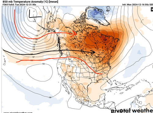
It’s pretty stinkin apparent to me as to why we’re in the situation we’ll be in. Looking at the GEFS 850s and it’s clear our Pacific jet is absolutely raging just after Christmas and at least through new years. You have the most modest PNA going on but it really doesn’t matter because the jet fuel is aimed right at the top of the ridge, flooding all of Canada and the lower 48 with mild air. I guess if there’s any optimism, that’s what it is, mild air, but I know we’re starting to approach prime climo and this isn’t what anyone wants to see. idk what’s going on with the Pacific, I’d say it’s likely tied to a higher amplitude phase 6 MJO but we’ve seen the Pacific jet torch defy all odds for years. I’m hanging on to optimism, not necessarily because I’m ok with the lack of snow, I want it as bad as anyone, but eventually we’re going to crack the drought and I’m just at the point where I’ve been let down enough to not let it phase me anymore.
-
I’m not sure what everyone is fretting about anyways. Nobody wants cold weather the day you’re supposed to be handling returns at Target and Best Buy.
-
It’s also been warm at 5+ days the entire month of December
-
Feels like it’s been a minute since we’ve had one of those truly raw days like today.
-
Meanwhile the 12z euro lays down a Christmas Day snow from Alabama to middle Virginia.
-
That was such an underrated event in our neck of the woods. Saw a little bit of everything and the snow over-performed. Looking back at pictures - roughly 6 ish inches of snow, a nice crust of sleet and a very minimal glaze to top it all off.
-
The Torch Town thread is also now live for those who need it
-
A safe space for all Merry Torchmas chatter and beyond. can we pin this to keep the mid-long range thread clean? @jburns
-
We’re getting ready to traverse through a reasonably high amplitude phase 6. All is going as planned. Phase 7 isn’t all sunshine and roses either for the upper and mid south. Patience as we propagate into high amplitude 8 and 1. It’s still autumn on the calendar.
-
I think Jan is going to have to be our shot. That’s when the -EPO should be working in our favor the most.
-
Yep and I don’t like the amount of northern stream dominated runs we’ve seen so far. Clipper energy just doesn’t pan out for us. I’ll be happy for folks if they score but man. Long gone are the days of overrunning events and gulf lows (that don’t cut west).
-
Fortunately no warm weather regardless. The last frame is a suppressive look with a monster 1045 high over the Ohio valley. No driving, chipping and putting, just nose bleeds and chapstick.
-
Regardless, I’ll rejoice in not having to wear shorts this Christmas. It’s sad that a seasonable to cold Christmas feels like you’re scoring an absolute coup of a victory.
-
A reminder that big storms in this region tend to honk loudly and honk early on the models. Idk if I’d consider the last few days honking, but the signal has been consistently there time and time again. Carry on.
-
Predicting the polar vortex and where the lobes of energy head is always a crapshoot but man does it look stretched and warped on LR guidance.
-
And the signal has been there for not only days but borderline a week now.
-
5.15” in the big town of Granite Falls over the past 24hrs.
-
Ever since Helene, the wind has given me a bit of anxiety. Our house was so fortunately lucky that day to lose trees all around it but have none hit it. I’m surrounded by very mature pines and when I get 4+ inches of rain like this, even 20-30 mph gusts make me nervous.
-
Are we ever going to figure out how to have normal rain again? Over 3 inches today alone here after a bone dry stretch. I swear it’s either drought or flooding rains.
-
Yes, the post Christmas timeframe closer to New Years has the most promise since the PNA looks like it’ll build and the MJO likely heads into phase 7. I think anything before then is gravy we should appreciate .
-
I do think these past few weeks have been weird and I’m not sure any normal thinking for the LR is completely in play. Optimistic we’ll get some help in the eastern Pacific and maybe for once the background state isn’t so hostile.
-
Having seen the MJO projections yesterday, I’m sort of surprised the ops aren’t showing more warmth in the mid-long range. I’d cash out on the 21st for the rest of winter with what the Euro is showing.
-
I crave a Miller A like I crave a winning franchise in the city of Charlotte.


