

AMZ8990
-
Posts
1,167 -
Joined
-
Last visited
Content Type
Profiles
Blogs
Forums
American Weather
Media Demo
Store
Gallery
Posts posted by AMZ8990
-
-
36 minutes ago, nrgjeff said:
Surprised how quiet the thread has become. We don't do ice? I certainly agree ice is by far the worst kind of weather.
Arctic front may surge more into Middle Tenn. OHX has been hinting at teeing up stronger winter / ice messaging after getting the public aware of the flooding first.
Saw MEM occasionally above 32 on CAMs. Overmixing. Little CAD east of the Ozarks is going to keep the Delta freezing and probably also the Memphis metro.
Pain. Pain. Pain.
Yeah, Ice storms are just no fun. Wish we were gonna see snow like OKC is but that’s just not on the table for us. Hoping it doesn’t affect us to bad, ice could be crippling for some though depending upon the area.
-
6 hours ago, fountainguy97 said:
4" of powder here. Rates pushing 2" at times.
High-res performed horribly but some of their longer range runs hit it right on the money. I think the low DGZ and moisture caused them to really struggle. HRRR only showed snowfall along the heaviest showers but reality we saw a pretty widespread area of light/moderate snow from the NW flow.


That’s awesome man!!
-
 1
1
-
-
February discussion for all things winter in the Tennessee Valley Sub-forum. When we have a likely event 2-3 days out we can create an individual thread for said storm. It helps for record keeping purposes as a lot us like to look back on old threads to learn, etc. Hope everyone is doing well.
-
1
-
 3
3
-
-
12 minutes ago, John1122 said:
Lots of honking for a big ice storm, a devastating one in Western areas. Crazy that the GFS had that look at D15 or 16.
The Euro and UKMet spread winter across the state.
I’ll pass on the Ice Storm. Just hoping for a good snow before winter leaves us for the year. I agree with your sentiment about the GFS too, it’s been really impressive at times sniffing out storms in the long range.
-
4
-
-
6zGfS has a very active storm track over the next 10-12 days. It’s basically a storm rolling through the forum every 3-4 days. Really good potential going forward for trackable storms in our forum.
-
6
-
1
-
-
Just now, John1122 said:
That stinks. I figured you'd get 3 to 5 easily. This has just been a weird storm. I've got 3 inches, 5 miles west has 6 and 10 miles east has bare ground.
That’s exactly how it went here, south part of the county along the Mississippi line got absolutely hammered but you can’t even tell it snowed in the top half of the county 20 miles north. Same scenario in our border county Mcnairy county.
-
2
-
-
13 minutes ago, Uncle Nasty said:
Hate to sound like a broken record but still moderate snow here. 5 miles away nothing.
I came up with a new quote for winter in the south. The beer made me think about it.
"Winter weather in the south is like a blind date. Never know what you're going to get".
Sent from my moto z4 using Tapatalk
My house got maybe a 1/2 inch of snow, 30 miles south, east and west of me got 3 inches+. Pickwick lake picked up like 5 inches. It’s definitely disheartening when a system pans out this way. Pretty cruel honestly, I hope you guys out east fair better than I did.
-
1
-
 1
1
-
-
2 minutes ago, Dsty2001 said:
Wasn't most of the east valleys totals supposed to come from later today/tonight anyways?
Yes
-
1
-
1
-
-
Took awhile to change over here but I’ve had light sleet for the last hour. Good glaze on everything. Snow is mixing in now
-
3
-
-
4 minutes ago, TellicoWx said:
Correct, the way the cold is wrapping in Memphis down to Western MS will changeover before NE AR
Yeah man, it’s pretty neat to see it unfold. It’s weird to see it on radar but it’s beautiful at the same time. Mother Nature is showing out with this one
-
1
-
-
1 minute ago, dwagner88 said:
I sense some foreshadowing here. . .
Come on Wagner, we all knew this event was gonna start out as rain. Let’s try to keep some positive mojo going on in here. lol
-
2
-
 1
1
-
-
1 minute ago, Shocker0 said:
He's just been getting rain while everyone else has been getting snow all around him
That’s what I’m saying though, the changeover to snow for him wasn’t supposed to start until around 8pm for Batesville. The snow line is inching its way southeast. He should be in a good spot
-
1
-
-
5 minutes ago, PowellVolz said:

.8 inches of heavy wet snow, you know that will be a beautiful sunrise there tomorrow morning!
-
5
-
-
6 minutes ago, Shocker0 said:
On the other hand, my buddy in Batesville, AR has 0" still and NWS had him at 3-5". But it's like he's in a snow dome or something.
It wasn’t supposed to start snowing for them until tonight. They should be getting into it within the next few hours. 8-1am is their prime time to rack up some snow ⛄️
-
1
-
1
-
-
8 minutes ago, PowellVolz said:
Interesting…

.The Ozark mountains in Arkansas were supposed to get 4-8 from this. The quachita mountains were 2-4. Reports from north/central Arkansas have all been overperforming. Which is good
-
2
-
-
6 minutes ago, *Flash* said:
I'm basically screwed at my location. Question is: How far SE do I need to chase?
I feel ya man, I’m as nervous as you are honestly. And that is the million dollar question isn’t it. The Weather channel Mets are still talking like Nash is in line for 3-5. I honestly don’t know what to think though. I’m gonna try and stay up to nowcast tonight in bolivar, maybe then we can come up with the best spot to go hunting for a big snow.
-
2
-
-
According to the fine folks in Ark/Kansas Thread, The HRR was 10 degrees too warm on their forecast for today. Had them at 42 and they haven’t got over freezing all day. Looks like they’ve picked up 1-3 inches of surprise snow in spots that weren’t expecting much. Figured some of you would enjoy knowing the HRR forecast overdid the high temps today in northern/central Arkansas
-
6
-
-
1 hour ago, Carvers Gap said:
The NMB model bumped up and inch or two or your area it looks like at 6z. Man, I have such low confidence in modeling for this storm.
Thanks, CG. And I’m right there with you man. Not having uniformity along all models is nerve racking, especially when we are this close to said event. Hoping for the best while simultaneously preparing my mind for the worst, lol.
-
1
-
-
13 minutes ago, Holston_River_Rambler said:
No clue how this will impact it, but looks like the shortwave is running about 45 minutes to an hour behind where the mesoscale models had it.
NWS must of seem something they liked last night, they bumped totals up to 3-6 instead of 2-4 in my neck of the woods.
-
4
-
1
-
-
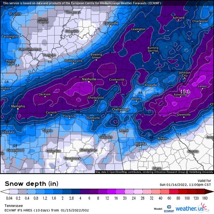
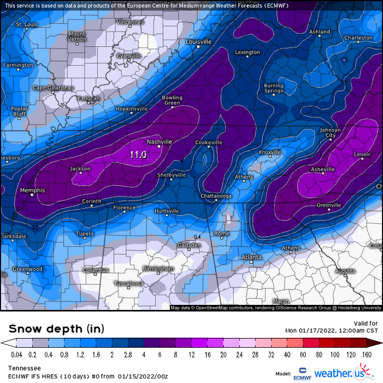
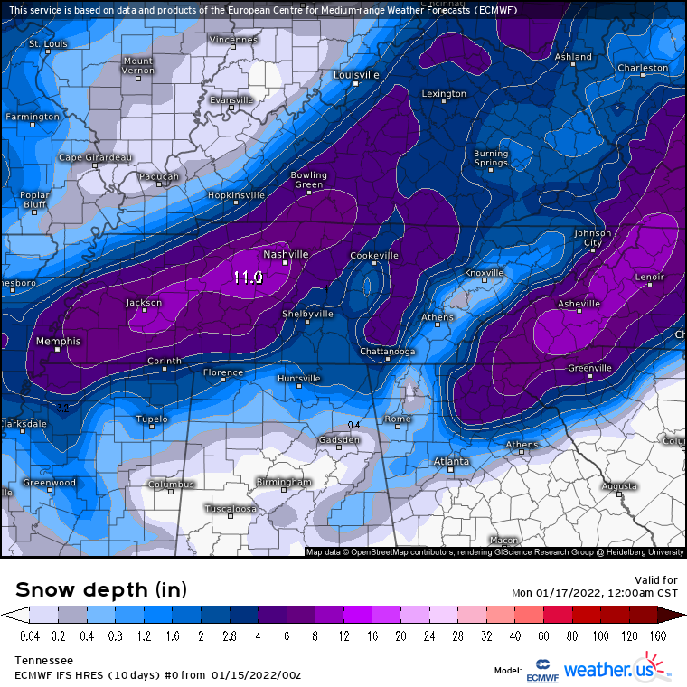
For my west Tn and part of middle Tn folks. Here is a map NWS Memphis put out early this morning. It puts down 3-6 for most of west Tn except the far northwest corner of the state. I-40 from Jackson to Nashville looked like it Was in a good spot again, Good look for the majority of west Tn also though.
-
28 minutes ago, Weathertree2 said:

I’ll say this, the EURO has been consistent with this look. Hard not to bite on this with that consistency. Gonna be a long night of tracking ahead!
-
1
-
-
It’s a waiting game at this point guys and gals. The Models (specifically short range ones) are gonna spit out some wonky looking solutions while they try to figure out the temperature profiles/timing in the possibly affected areas. This is a long duration event though, so don’t get hung up on seeing rain in the forecast because Everyone is gonna see some rain before they get snow with this event. And Often times those rain to snow events Produce the biggest snows as well.
-
2
-
2
-
-
4 hours ago, John1122 said:
Canadian still has this one.

It went crazy on the 6z run, big totals in SW Tn that run
-
1 hour ago, John1122 said:
OHX pulled the trigger on a winter storm watch for 3-7 inches with higher amounts possible across what appears to be it's entire CWA or close to it.
Same thing on the west side of the state. Says 2-4 for MBY.
-
1
-


Feburary 2nd-4th Winter Storm Thread
in Tennessee Valley
Posted
That would be devastating if it came to fruition. Models seem pretty dialed in on that heavy section of freezing rain accumulation though. The magnitude alone of this storm is impressive without the ice totals factored in.