

AMZ8990
-
Posts
1,167 -
Joined
-
Last visited
Content Type
Profiles
Blogs
Forums
American Weather
Media Demo
Store
Gallery
Posts posted by AMZ8990
-
-
Just now, John1122 said:
I honestly expected them tomorrow.
I thought the same, but I’m glad to see them put it out ahead of time to give people plenty of advanced notice.
-
 3
3
-
-
Winter Storm Watch
URGENT - WINTER WEATHER MESSAGE
National Weather Service Memphis TN
254 PM CST Fri Jan 12 2024

ARZ009-018-026>028-035-036-048-049-058-MOZ113-115-MSZ001>017-
020>024-TNZ001>004-019>022-048>055-088>092-130500-
/O.NEW.KMEG.WS.A.0001.240114T1800Z-240116T1200Z/
Clay-Greene-Craighead-Poinsett-Mississippi-Cross-Crittenden-
St. Francis-Lee AR-Phillips-Dunklin-Pemiscot-DeSoto-Marshall-
Benton MS-Tippah-Alcorn-Tishomingo-Tunica-Tate-Prentiss-Coahoma-
Quitman-Panola-Lafayette-Union-Pontotoc-Lee MS-Itawamba-
Tallahatchie-Yalobusha-Calhoun-Chickasaw-Monroe-Lake-Obion-
Weakley-Henry-Dyer-Gibson-Carroll-Benton TN-Lauderdale-Tipton-
Haywood-Crockett-Madison-Chester-Henderson-Decatur-Shelby-Fayette-
Hardeman-McNairy-Hardin-
Including the cities of Piggott, Corning, Paragould, Jonesboro,
Harrisburg, Blytheville, Wynne, West Memphis, Forrest City,
Marianna, Helena-West Helena, Kennett, Caruthersville, Southaven,
Olive Branch, Holly Springs, Ashland, Ripley MS, Corinth, Iuka,
Tunica, Senatobia, Booneville, Clarksdale, Marks, Batesville,
Oxford, New Albany, Pontotoc, Tupelo, Fulton, Charleston,
Water Valley, Coffeeville, Bruce, Calhoun City, Houston, Okolona,
Amory, Aberdeen, Tiptonville, Union City, Martin, Dresden, Paris,
Dyersburg, Humboldt, Milan, Huntingdon, Camden, Ripley TN,
Covington, Brownsville, Alamo, Jackson, Henderson, Lexington,
Parsons, Decaturville, Bartlett, Germantown, Collierville,
Memphis, Millington, Somerville, Oakland, Bolivar, Selmer,
and Savannah
254 PM CST Fri Jan 12 2024

...WINTER STORM WATCH IN EFFECT FROM SUNDAY AFTERNOON THROUGH
LATE MONDAY NIGHT...

* WHAT...Heavy snow possible. Total snow accumulations of 3 to 8
  inches possible.

* WHERE...Portions of East Arkansas, North Mississippi,
  Southeast Missouri and West Tennessee.

* WHEN...From Sunday afternoon through late Monday night.

* IMPACTS...Travel could be very difficult. The hazardous
  conditions could impact the morning or evening commute.
-
5
-
 1
1
-
-
Winter Storm Watches now up for Hardeman county in west Tn and the surrounding areas. Calling for 3-8 inches of snow as of right now.
-
3
-
 1
1
-
-
Our system is currently working through the Pacific Northwest. Portland Oregon getting snow, sleet, and rain from this system. Almost the entire state of Oregon is under some form of winter weather watches and warnings. Idaho is more of the same with a large swath of blizzard warnings there as well.
-
7
-
-
14 minutes ago, *Flash* said:
You and me both. Even Dickson County north of 40 does well on this one.
Hopefully we can stay at home and see the snow for this storm! It will be interesting to see when the warnings and watches start to get put out.
-
1
-
-
1 minute ago, John1122 said:
@AMZ8990 Should be singing "Oh Canada!" at this point and I'll join him. We may need to change getting "nam'd" to getting "rgem'd".
Heck yeah! I will sing it loud and proud, lol. What a run!!
-
2
-
-
2 hours ago, John1122 said:
No morning disco from Memphis yet. That area has the best shot at snow the way it looks now but as always, everything is subject to change.
This morning the ABC 24 news Meteorologist in Memphis talked about the possibility of accumulating snow in west Tennessee along with bitterly cold temperatures for next week. He said he was going to wait until tomorrow morning to start talking about/predicting snow totals. Guess we will see what he says tomorrow
-
3
-
-
3 minutes ago, ShawnEastTN said:
Looks like the precip modeled to build into the region this evening and tonight for snow showers is starting to show on OHX radar heading east. See some Mping reports of light snow near Memphis currently. Maybe this will over produce like the rain QPF did with this system.

Sent from my Pixel 7 using Tapatalk
Can confirm. Very light snow showers mixed in with a light rain from Memphis and into Fayette and hardeman counties east of Memphis. Wind has been screaming all day long, tough day for folks who make their living outside.
-
6
-
-
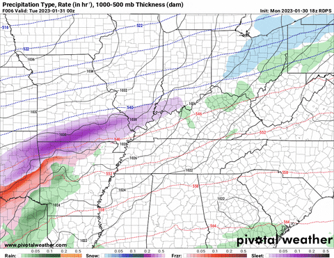
26 minutes ago, TellicoWx said:
Rain/snow line enters state around hr 135, and exits around 180...

Hard not to get excited looking at that!
-
Rain is picking up in west Tennessee along with the wind. I have seen multiple lightning strikes on my way home from work. Hearing Plenty of thunder rumbles as well now at home. Time will tell if this is a good omen!
-
8
-
-
5 minutes ago, tnweathernut said:
The system that follows around day 9-10 missing the TN Valley to the south interests me….
Yeah, lots of energy flying around on modeling the next ten days. It Will be interesting to see if we can get some cold air to cooperate with us on one of these upcoming storm systems. Gotta love the recent trends on storm tracks though!
-
6
-
-
5 hours ago, Carvers Gap said:
This was a textbook over-running event in west TN. When we see cold charge into TX w/ a slight eastward push...it often doesn't make it past the Plateau or even to the Plateau at all. Wave after wave of frozen precip rolled through that area. Modeling did a great job with this event, especially the CMC and RGEM. The Euro was very late in recognizing where the cold air boundary was. Also, the GFS(which was thrown out by some services) was very close to being right w/ its cold air boundary. The GFS has been decent inside of 5 days.
Yeah, it was just tough when you know we were oh so close to a really nice snow event. But that is life, just glad we got to see some wintry action!
-
2
-
-
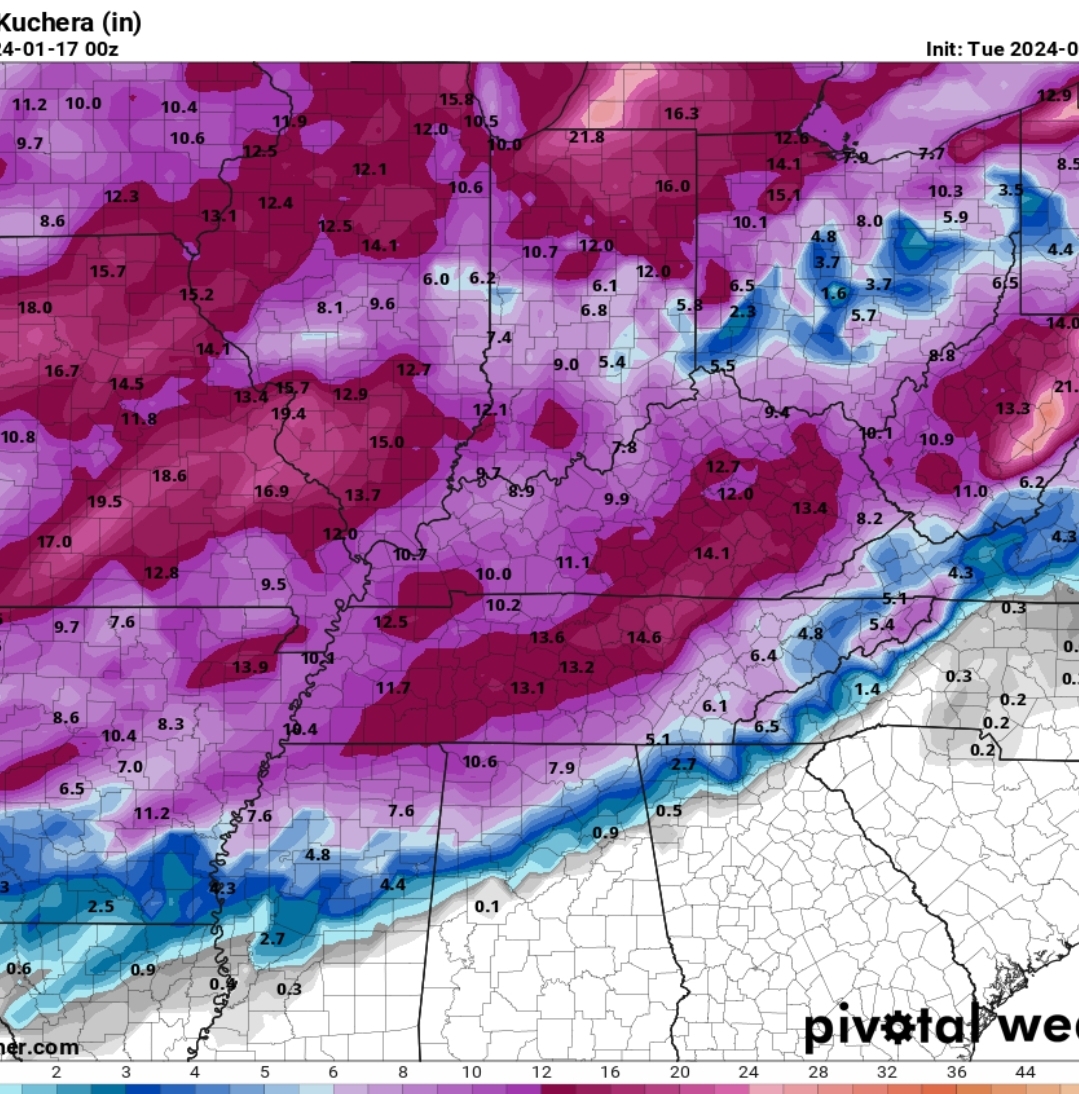
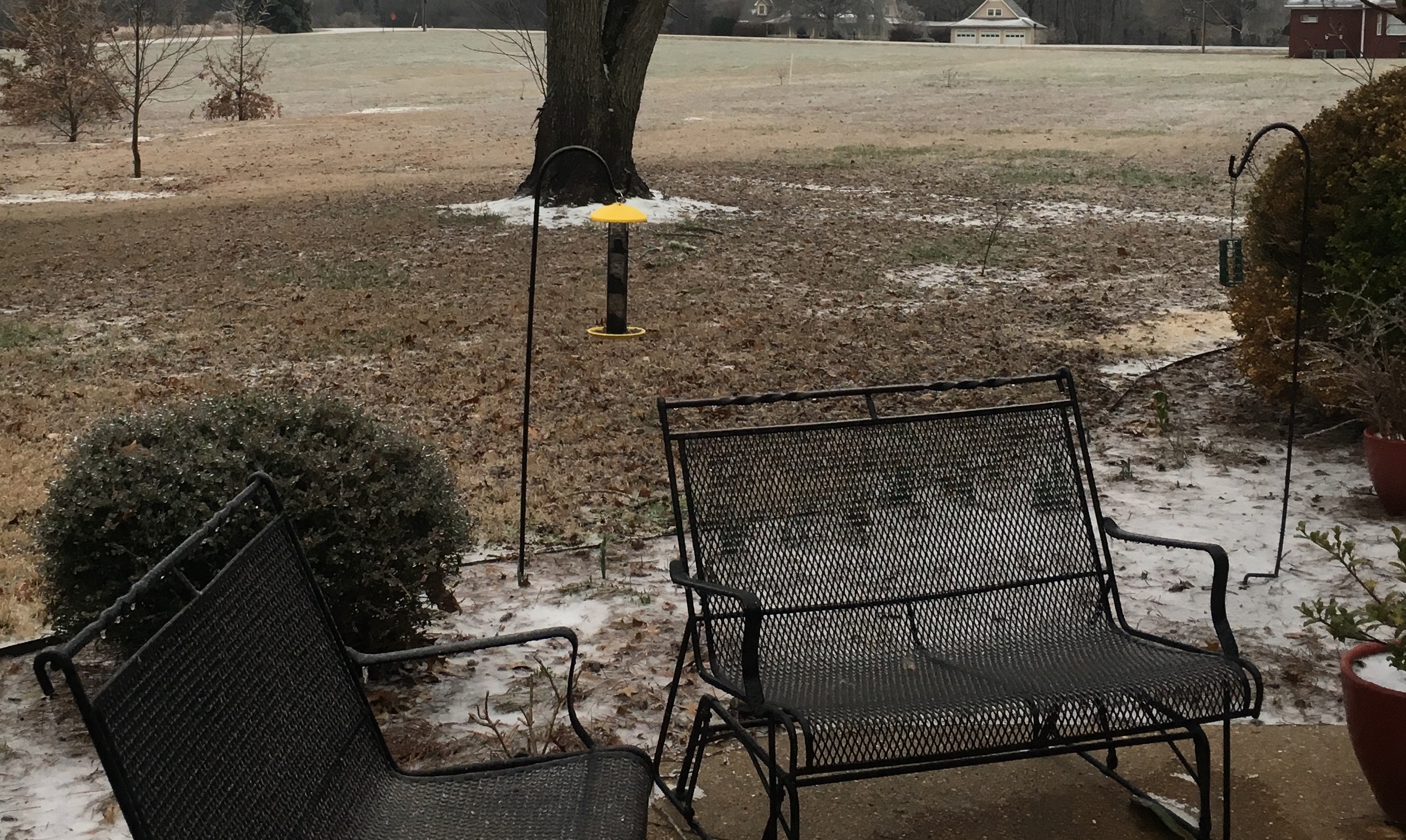
Round 3 last night packed a punch, definitely added to our ice total significantly.
-
5
-
-
20 minutes ago, Coach B said:
I'm close to mm 30 on I-65. Got about .1" of glaze on elevated surfaces here. Nothing on the roads best I can tell. Temp bottomed out at 29. Currently holding at 30. Curious to see how temps recover today and if there is some chance of a little more tomorrow morning.
Roads are pretty bad in west Tn, especially the back roads. My road is essentially a block of ice. As my dad would say, “it’s slicker than owl crap out there”.. lol
-
1
-
 5
5
-
-
-
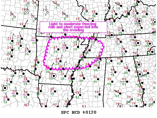
Ice storm warnings now up for a large portion of central Arkansas as well as the Dallas area and surrounding counties in Texas. All of West Tennessee under the warning now, looks like they moved the warnings 2 counties eastward into middle Tennessee also
-
2
-
-
30 minutes in and Moderate sleet is falling at the house now, cars covered and concrete driveway pad is extremely slick already.
-
6
-
-
Just now, Carvers Gap said:
Radar is lit.
It really is! Check out some of the Memphis interstate cameras when you get a chance, roads are turning into an ice rink as we speak. I-40 Is a mess right now
-
2
-
-
-
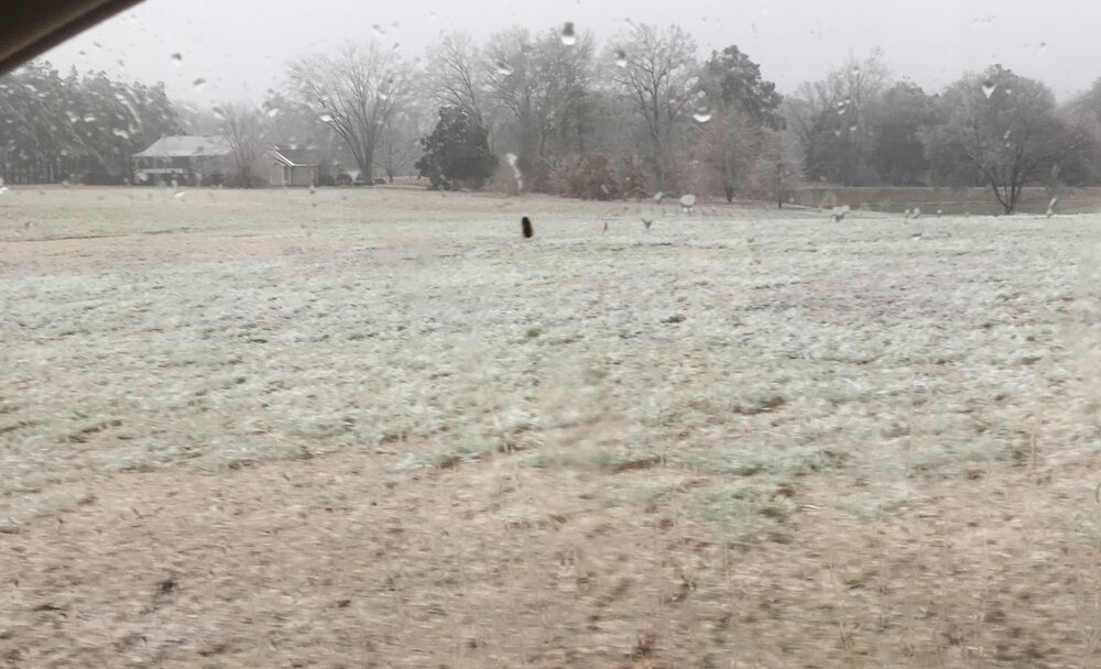
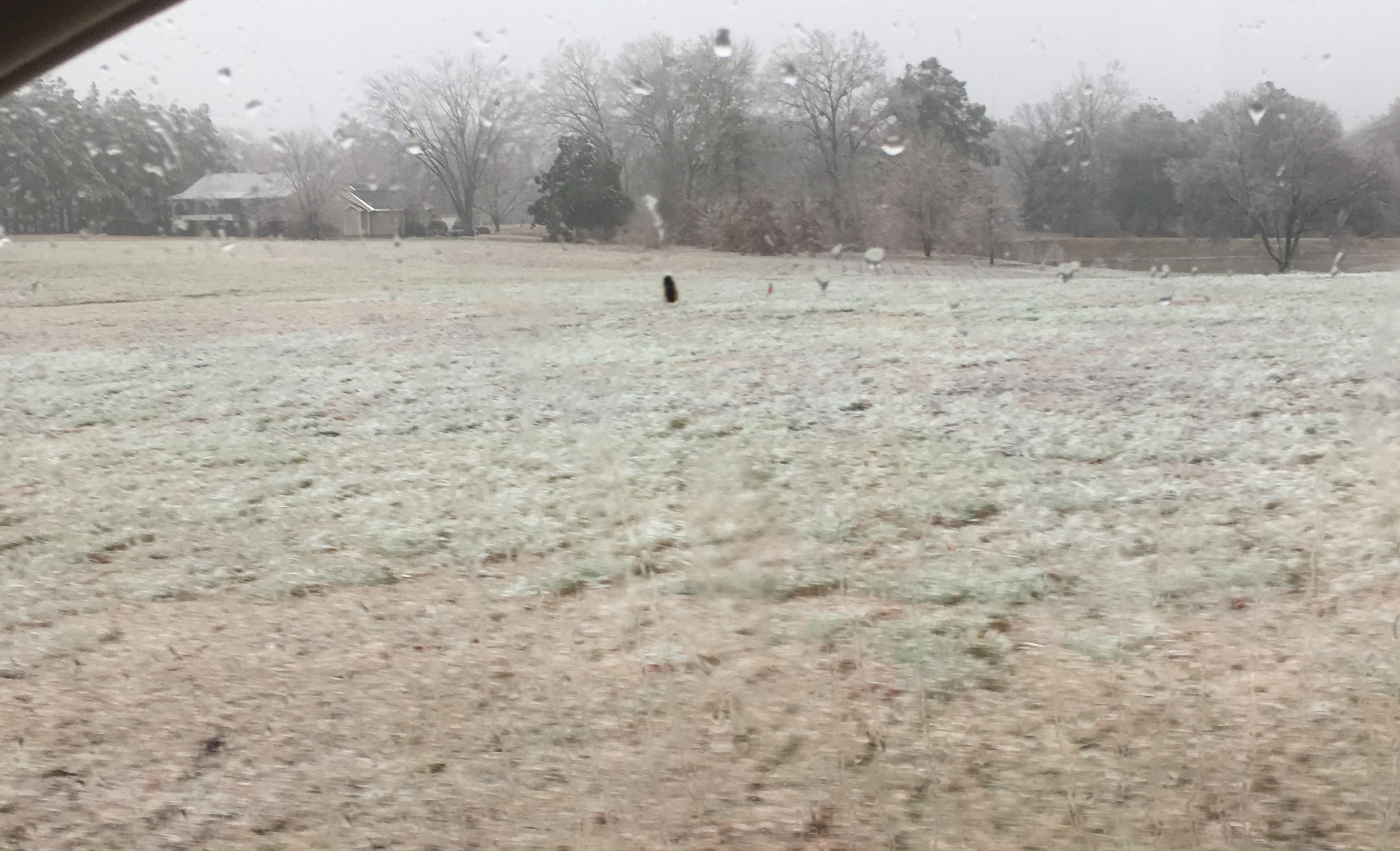
Light freezing rain/sleet starting to fall in hardeman County now, it’s cold out there too man. Wind chills are brutal today
-
2
-
-
20 minutes ago, Jed33 said:
Looks like it’s about to get real in Memphis! Heavy ZR moving in now temp 28 Dp 26 yep that’ll do it!
Yeah, rush hour traffic this afternoon will be terrible. Hopefully everyone can get home safe
-
1
-
-
Looks like 70% of the state of Texas is now under a winter storm warning, south-western Arkansas also in on that warning upgrade. Should be a fun day weather wise across the nation to say the least. I Picked up some icing with last nights system here in bolivar. Maybe .10 of an inch max so far, nice glaze of ice on all the trees and cars. round 2 tonight looks like it’s going to pack more of a punch though. Supposed to start here around 4pm
-
2
-
-
Dallas also reporting heavy sleet at the moment, roads will be a mess if that trend continues.
-
1
-
-
15 minutes ago, Holston_River_Rambler said:
Yeah, looks like more sleet this run, especially with the second wave
Looks similar to last weeks system that blasted north-western Arkansas, southern Missouri, Illinois and Ohio with 3-6 inches of snow. These systems Have been one after another this month. One of the wettest January’s I can remember
January 15th-17th 2024 Arctic Blast/Snow Event
in Tennessee Valley
Posted
winter storm warnings now up in west Tennessee