

AMZ8990
-
Posts
1,167 -
Joined
-
Last visited
Content Type
Profiles
Blogs
Forums
American Weather
Media Demo
Store
Gallery
Posts posted by AMZ8990
-
-
6 hours ago, BlunderStorm said:
Absolutely beautiful outside right now. A snow squall is passing over with bursts of 2-3 in. an hour rates. Some of the snow is coming down over an inch in diameter. I finally got my share haha. Since it's arrival the temperature has dropped a whole 5 degrees from 32 to 27! UPDATE 1: Temperatures have risen back to 29 but it is still snowing at a light to moderate rate. Soon, I will take a measurement once this period of snow ends. UPDATE 2: Another smaller snow squall is currently (1:14 ) passing over with more heavy rates. UPDATE 3: A good 1.3 inches of snow IMBY fell in the last hour and a half. A few snow showers may follow after but this looks to be the end of the snow squalls.
That’s awesome man, sounds like a fun day!!
-
 2
2
-
-
1 minute ago, John1122 said:
Well, I'm back in the yard stick game on the FV3. That's about as good a run across our region as you'll ever see. 12 plus across so much of the state.
Right!! We dream of that all year.
-
The differences in snow totals between the pivotal fv3 and the tropical tidbits fv3 is pretty insane. Not too mention there is some heavy pockets of freezing rain in Arkansas, South Carolina, and Georgia that showed up that run. Scary amounts of ice if it planned out. Definitely need to keep an eye on the ice totals with this storm.
-
19 minutes ago, tnweathernut said:
Oklahoma and Arkansas got NAM'd at 18z. West TN was in the crosshairs if it ran a few hours longer. Not that anyone is really all that curious about the 18z NAM past 48 to 54 hours.......
Was thinking the same thing. The Nam is about all I’ve got left here in west tn!
-
1
-
-
16 minutes ago, PowellVolz said:
Afraid the game is over for anyone SW of 40/81.
.Hush Powell!! Lol
-
1
-
 1
1
-
-
24 minutes ago, ShawnEastTN said:
12Z NAM of course at 84, but still not a bad look for feature placement.
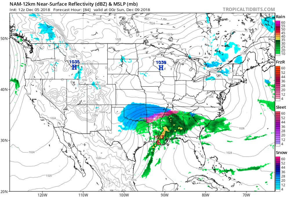
Not a bad look at all Shawn, it’s nice to have the short range models in range now!
-
6 minutes ago, Carvers Gap said:
After reading MRX, I am going back and looking these. Going to have to be quick so these may be sloppy and a bit disjointed:
1. Don't ever want to lose the Euro...and we did on temps. That said it is run one, and 0z Euro is pretty much the same surface track placement that is has had for several runs. The high looked good, but the shape was different. It looked like it lost (to use a football term) containment behind the system. Basically means there was less high pressure on the backside, and the storm jogged north. Someone mentioned to me that might be a confluence situation.
2. The 6z GFS is noticeably south with its snow axis compared to 0z.
3. The 6z FV3 looks about the same, but is slightly south with its snow axis...but not as much as the GFS.
4. The 0z CMC looks goof for NE TN and some of central E TN.
5. I one had never seen the 12z Euro run yesterday, one would say that the overnight 0z mean looks pretty similar to 0z of the night before. The differences are that the precip shield is further north and it really "wants" to be iffy about lower elevations. NE TN still looks good...but trends matter right now.
6. The 0z GEFS was very beefy. The 6z GEFS was maybe beefier and trended south. It had 6-10" in valley locations of NE TN.
7. Can anyone post the UKMET...whatever you can get your hands on. No time to proof...hope it does not look like chicken scratch. Gotta run.
Yeah the 6z FV3 was a lot better for me that run, definitely could notice the shift south with the snow axis, especially in central Arkansas with some big totals that run. The margin for error with this storm is gonna be so small though. The rain snow line with this storm looks like it’s gonna be an all out war zone. Could be great for whoever ends up on the cold side of the rain snow line!
-
4 hours ago, John1122 said:
Last night, Louisiana to here with these 850s.

Tonight at the same hour.

Good look
-
1 hour ago, TellicoWx said:
12z EPS...cant ask for too much more at 5 days out

Definitely a good look for our northern and eastern part of forum. I could use a jog south a few miles but what’s new!
-
35 minutes ago, *Flash* said:
12z CMC trolls west TN. Double digit difference between Poplar Bluff and Dyersburg.

12z ICON also paints a reasonable picture with tempered amounts, but at least something to show for.

Overall, not only does the 12z suite capture Miller A/low track continuity, but also hints at cold air potentially catching up to make late Sunday/early Monday interesting. Could be off, but certainly looks like a favorable theme.
The Nashville snow dome moved west I see!! Haha
-
1
-
-
2 minutes ago, TellicoWx said:
1" for both
Cool, thank ya sir.
-
5 minutes ago, TellicoWx said:
12z EPS mean:
TRI: 6"
TYS: 2" (south knox), 3.5" (north knox)
Chat: 2"
Cross: 4"
Highest run so far for northeast TN. EPS looks almost identical to GEFS mean.
@TellicoWx, what was the mean for Memphis or Jackson Tn?
-
GFS is looking good thru hr132, HP a little further west this run which really gets the snow cranking in Arkansas and west tn by 132. Solid track so far on the 12zGFS, by 144 the LP is off the coast of SC.
-
54 minutes ago, Carvers Gap said:
I think it might not be a bad idea to get the LR stuff into a new thread. @AMZ8990, you manage the thread titles for both threads so this should be easy. Why not change the original Winter Spec Thread to “Long Range Winter Speculation 18-19” w a subheading of “2-3 Month Long Lead Discussion”. Then change the Winter Spec Dec Thread to “December 2018 Pattern and Forecast Discussion.” That should clear things up and even make the threads a bit easier to follow.
Sounds like a plan @Carvers Gap, I’ll get them changed up here shortly. I agree that shoulD clear up any uncertainty people are having!!
-
 2
2
-
-
7 hours ago, jaxjagman said:
And this is what i'm talking about.I got bashed for starting a slight severe risk thread,but yet when there is a dusting of snow risk we start a thread here sort of speaking no one has a problem with this.I admit i like severe as much as snow but lets not do double standards here,it's what it seems to me.Any snow or severe risk should deserve a thread,if it happens or not
Yeah we only made the December thread so we could have individual conversations about what’s going on in December only. The regular winter spec is more for he entire winter outlook, climo outlook for Jan and February versus just December. We had so much to talk about long term temps changing cold vs early December cold snap that we decided to divide the two to help not getting anyone confused. I can change the name of this thread if that would help some. And Jax, I don’t know who gave you a hard time about the severe thread but I don’t feel that way at all. The severe thread is vital to our discussions and it is also of great help in alerting people to possible severe outbreaks. You do a great job with that and I don’t want to see those severe threads go anywhere.
-
4
-
-
38 minutes ago, tnweathernut said:
The 6z GFS FV3 says “good morning”. Classic track for a heavy TN Valley snowstorm.
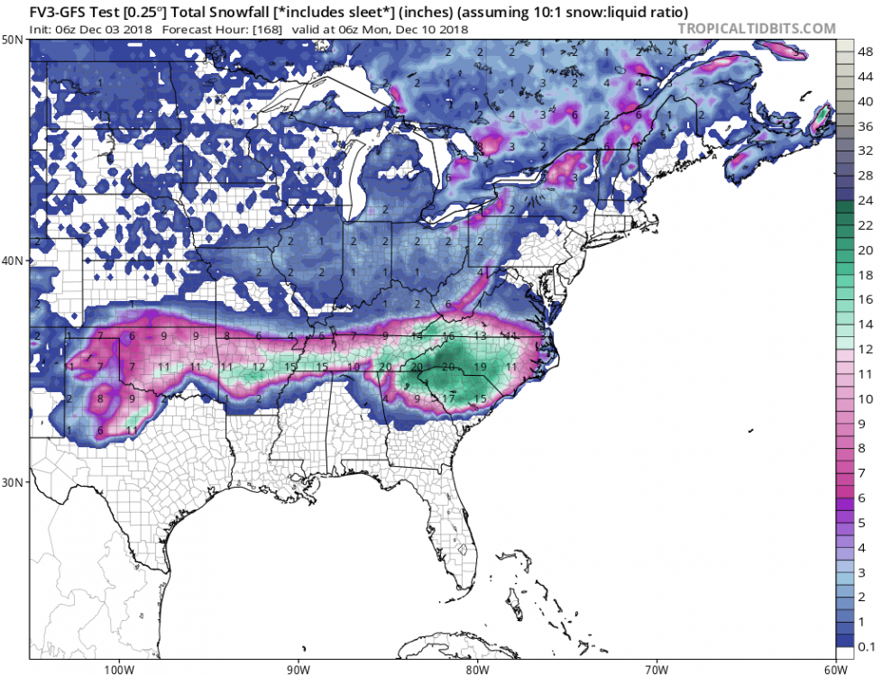
Saw that too, I’m drooling on my way into work this morning!! Haha
-
18 minutes ago, Carvers Gap said:
The 12z Euro has support from the JMA this evening. Slider for southern areas of the Upper South. Strong high over the top. Grabbed that info(not verbatim) from the SE forum and agree.
JMA shows 850mb temps below freezing for the entire forum from HR120 thru HR168 as well. Good look for sure.
-
33 minutes ago, Carvers Gap said:
Like I said, at this time frame a lot of options are still on the table. Looks like the range right now keeps the forum alive for hopes of snow. Very good 12z suite. Of course, I am pulling for MBY, but if Chattanooga/northern MS/northern AL gets hammered...I can live with that! The folks in Memphis and Chattanooga get to see the rest of us talk snow and patiently wait. They are over due! I suspect the EPS should have some fun individual solutions as well. That got pretty wild at the end of that event. Looks like part of it went OTS and the other part formed a coastal that goes to NC.
Been hoping for a big dog storm for a long time now. I can’t remember the last time we got over 4” In one storm. If we could get into that 4+ range I would be ecstatic!! Lol
-
2
-
-
2 hours ago, Carvers Gap said:
Those maps are about to give me a heart attack! LOL. That is my absolute favorite track to follow. I hope(fingers crossed) that it continues to take the low road. That and we get strong enough hp over the top. I am pleased to see the trend of the hp coming back into play...it was absent a couple of days ago. I remind myself that great solutions come and go at this range. But yeah, I ain't gonna lie...I like a good clown map. LOL.
Me and you both, ha!! Clown maps are like a good side salad, it’s a great buffer before the main course. Hopefully the main course leaves us all happy.
-
4 minutes ago, Carvers Gap said:
That run is a classic example of my favorite track for NE TN. Absolutely no idea if this verifies...so everyone please understand that. But for discussion purposes...
The slp slides by w a good, strong HP over the top. As the slp slides by and turns NE, it draws in the cold from the hp. That track is slightly east from a truly, perfect track. But that is close. Those types of systems are very tough to forecast in terms of snow. It is often very tough to know exactly when the valleys switch over and how much precip is left when the switch occurs. But that is a big dog track...and still a long way to go. I don't have a ton of confidence, because I have seen these great tracks go to pot as the event gets closer. But man, who doesn't get just a little bit excited when seeing a map like 1234 just posted!?
The guys in the southeastern forum are gonna have a heart attack if these maps continue to pour out these hearstopping snow totals in the CAD areas. Lol. I’ll be interested to see what the 12z euro holds.
-
1
-
-
6 minutes ago, Carvers Gap said:
Much better placement and strength of the parent high pressure. That is the money track for portions of east central and northeast TN, northern sections of the Plateau, SE KY, and SW VA. We have more ways up here to lower snowfall totals than most imagine. Check out what the downslope does to the foothills communities of E TN and (the opposite) what it does to the southeast facing slopes of the Plateau and SW VA/SE KY. I think I saw 23" over the SE KY/SW VA border.
23” is pretty crazy to think about, I could see it happening in those areas you mentioned though. Did you see some of those numbers in central/northern Arkansas? They had close to a foot in several areas. This storm if modeled correctly is massive too. A lot of states could be impacted theoretically. Still a long ways to go though.
-
12Z GFS with some good developments out to HR144. 2m temps in Memphis go from 37 to 33 from hour 132 too 144. LP tracking right around the coast of New Orleans at 144 with the HP to our north over Wisconsin. ZR stars to cover west tn at 144 as well. By 150 the Rain snow line is right around Jackson to, but a good portion of central and northern Arkansas is seeing good snow at this time along with Jackson tn and it’s northern neighbors. By 162 the LP is off of the coast of Panama City, then the low pushes up the east coast and bombs the mountains of Northeast TN and eastern NC. North western SC gets in on the action too.
-
2
-
-
11 hours ago, Save the itchy algae! said:
UCF!
Boo, I was hoping Memphis would win!!
-
51 minutes ago, Carvers Gap said:
Congratulations to our Alabama fans(there are a few that drop in from time to time) on a big win in Atlanta tonight. Wow, what a comeback. Glad to see Hurts get a little redemption.
I’m with you on hurts, what a story. Darn nick nearly teared up in the postgame interview with hurts. As soon as he went in for tua I started to root for bama for hurts and hurts alone. The kid could’ve went anywhere he wanted to play ball but he stuck it out at bama. Hard work and preparation always meet an opportunity at some point. Glad jalen’s perseverance paid off for him and his team. GBO for life as always but I love a good redemption story.
-
1
-


Winter 2018-2019 Observations
in Tennessee Valley
Posted
3 inches isn’t to shabby seeing as it’s only early December. You might triple that Total by this time next week!!! Lol