
CNY-WXFREAK
-
Posts
3,872 -
Joined
-
Last visited
Content Type
Profiles
Blogs
Forums
American Weather
Media Demo
Store
Gallery
Everything posted by CNY-WXFREAK
-
Upstate/Eastern New York
CNY-WXFREAK replied to BuffaloWeather's topic in Upstate New York/Pennsylvania
We're getting absolutely crushed, wow, flake size is super ideal now too! -
Upstate/Eastern New York
CNY-WXFREAK replied to BuffaloWeather's topic in Upstate New York/Pennsylvania
It's gonna bang real soon! -
Upstate/Eastern New York
CNY-WXFREAK replied to BuffaloWeather's topic in Upstate New York/Pennsylvania
I'm not concerned one bit! Once the csi starts it'll only take 6-7 hrs of 2-3"/hr and we'll be good! if flake size doesn't improve totals won't be realized, oh well! -
Upstate/Eastern New York
CNY-WXFREAK replied to BuffaloWeather's topic in Upstate New York/Pennsylvania
Flake size has definitely increased in size too and whats to our South is just beautiful! -
Upstate/Eastern New York
CNY-WXFREAK replied to BuffaloWeather's topic in Upstate New York/Pennsylvania
We're gonna get absolutely crushed! -
Upstate/Eastern New York
CNY-WXFREAK replied to BuffaloWeather's topic in Upstate New York/Pennsylvania
Where's Logan at? He hangs in the NE forum. -
Upstate/Eastern New York
CNY-WXFREAK replied to BuffaloWeather's topic in Upstate New York/Pennsylvania
Theres a definite chance we go to Blizzard warnings if it gets much worse! -
Upstate/Eastern New York
CNY-WXFREAK replied to BuffaloWeather's topic in Upstate New York/Pennsylvania
Man its absolutely brutal out there, wow! Winds are ramping up big time -
Upstate/Eastern New York
CNY-WXFREAK replied to BuffaloWeather's topic in Upstate New York/Pennsylvania
Easy! -
Upstate/Eastern New York
CNY-WXFREAK replied to BuffaloWeather's topic in Upstate New York/Pennsylvania
Them first then its our turn! Discussion 0032 NWS Storm Prediction Center Norman OK 0524 PM CST Sat Jan 19 2019 Areas affected...northern Ohio... much of Pennsylvania... northern Maryland... far northeastern West Virginia... far southwestern New York Concerning...Heavy snow Valid 192324Z - 200230Z SUMMARY...Moderate to heavy snowbands continue to overspread the region, with widespread 1-2 inch per hour snowfall rates likely. DISCUSSION...Regional radar shows moderate to heavy snowbands continuing over portions of northern Ohio, and developing/spreading into portions of Pennsylvania and northern Maryland. Locations where these snowbands have setup are currently experiencing snowfall rates of 1-2 inches per hour. These observational trends are expected to continue for the next few hours. Strong mid-level frontogenetical forcing is resulting in broad vertical ascent over the region. RAP soundings indicate moderate vertical motion through the dendritic growth zone, helping to enhance snowfall rates. With time, areas of northern Maryland and southern Pennsylvania should transition to rain, but could experience some brief freezing rain as warm air advection aloft outpaces warming at the surface. -
Upstate/Eastern New York
CNY-WXFREAK replied to BuffaloWeather's topic in Upstate New York/Pennsylvania
Almost spot on! -
Upstate/Eastern New York
CNY-WXFREAK replied to BuffaloWeather's topic in Upstate New York/Pennsylvania
With ease too! -
Upstate/Eastern New York
CNY-WXFREAK replied to BuffaloWeather's topic in Upstate New York/Pennsylvania
And I'll take the over, easily! -
Upstate/Eastern New York
CNY-WXFREAK replied to BuffaloWeather's topic in Upstate New York/Pennsylvania
This hasn't even begun yet! -
Upstate/Eastern New York
CNY-WXFREAK replied to BuffaloWeather's topic in Upstate New York/Pennsylvania
HEAVY FREEZING SPRAY WARNING REMAINS IN EFFECT UNTIL 6 AM EST MONDAY... * FREEZING SPRAY...Winds of up to 30 knots and waves greater than 5 feet will create conditions favorable for heavy freezing spray. PRECAUTIONARY/PREPAREDNESS ACTIONS... A Heavy Freezing Spray Warning means heavy freezing spray is expected to rapidly accumulate on vessels. These conditions can be extremely hazardous to navigation. It is recommended that mariners not trained to operate in these conditions or vessels not properly equipped to do so...remain in port or avoid the warning area. -
Upstate/Eastern New York
CNY-WXFREAK replied to BuffaloWeather's topic in Upstate New York/Pennsylvania
You'd normally need a warm layer above somewhere and it looks like that's unlikely but if we get close enough to the mix line I'd think the possibility may exist. -
Upstate/Eastern New York
CNY-WXFREAK replied to BuffaloWeather's topic in Upstate New York/Pennsylvania
-
Upstate/Eastern New York
CNY-WXFREAK replied to BuffaloWeather's topic in Upstate New York/Pennsylvania
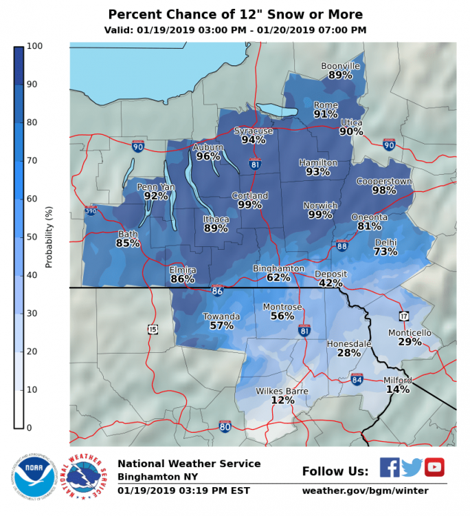
Guaranteed 14" + the 4 that fell so far = 17", I'll take it! -
Upstate/Eastern New York
CNY-WXFREAK replied to BuffaloWeather's topic in Upstate New York/Pennsylvania
That only goes out to 00Z Sunday, 2", lol! -
Upstate/Eastern New York
CNY-WXFREAK replied to BuffaloWeather's topic in Upstate New York/Pennsylvania
There's about 9/10's of an 1" left from the main event then another .5" of liq eq of lake effect! -
Upstate/Eastern New York
CNY-WXFREAK replied to BuffaloWeather's topic in Upstate New York/Pennsylvania
Lots more on the way, 18Z WRF nice!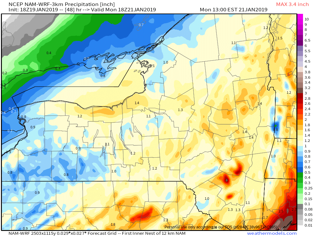
-
Upstate/Eastern New York
CNY-WXFREAK replied to BuffaloWeather's topic in Upstate New York/Pennsylvania
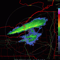
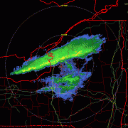
KBGM's radar is lighting up big time, nice! -
Upstate/Eastern New York
CNY-WXFREAK replied to BuffaloWeather's topic in Upstate New York/Pennsylvania
Still pretty light here but flake size has definitely changed so thats a good thing but definitely light and not even moderate yet so waiting. 2-3" so far but very grainy so thats about to change as temps rise as well -
Upstate/Eastern New York
CNY-WXFREAK replied to BuffaloWeather's topic in Upstate New York/Pennsylvania
I can't believe the difference in track, nuts! oRH goes over to plain rn, thats nuts! -
Upstate/Eastern New York
CNY-WXFREAK replied to BuffaloWeather's topic in Upstate New York/Pennsylvania
I don't trust this thing at all bro for sure!

