
CNY-WXFREAK
-
Posts
3,872 -
Joined
-
Last visited
Content Type
Profiles
Blogs
Forums
American Weather
Media Demo
Store
Gallery
Everything posted by CNY-WXFREAK
-
Upstate/Eastern New York
CNY-WXFREAK replied to BuffaloWeather's topic in Upstate New York/Pennsylvania
That Lake Erie band is absolutely incredible as it extends all the way to So Herkimer county, wow! -
Upstate/Eastern New York
CNY-WXFREAK replied to BuffaloWeather's topic in Upstate New York/Pennsylvania
Listen, we just went through a nice event with Harper so there should be no whining in this sub at all. We at least have a few events to watch and track but think about the MA and the NE folks as their hurting big time but they've been getting love from the snow Gods for a decade straight, or so it seems, with countless Blizzards. NWS in Tauton actually made it seem like blizzards are common place in New England, lol, yeah right! -
Upstate/Eastern New York
CNY-WXFREAK replied to BuffaloWeather's topic in Upstate New York/Pennsylvania
Wanna hear something really funny, not only am I missing the snow from LO to my North, but I'm missing the scraps from Lake Erie to my South, lol!! -
Upstate/Eastern New York
CNY-WXFREAK replied to BuffaloWeather's topic in Upstate New York/Pennsylvania
Has anyone looked at the GFS, lol, as I don't think it got the memo on the incoming cold, lol. It's downright balmy the last week of the run and the first 10 days aren't that exciting except for the Tug and the hills South of Kbuf so.......... I don't like Dry and cold and if that's the forecast, then it light as well be 50's and Sunny so I can get a bit of Vitamin D! -
Upstate/Eastern New York
CNY-WXFREAK replied to BuffaloWeather's topic in Upstate New York/Pennsylvania
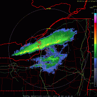
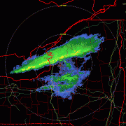
I know everyone is in LES track mode and I wish I was but this is a traditional LES event with a W to WSWerly wind flow, so congrats to all who get pegged in WNY and North of me. As you are tracking the LE I'm tracking a system for Mon-Tue of next week basically its on all guidance with basically a snowstorm on the Euro and a rain storm on some of the other guidance, so at this point its a toss-up but if it were to be snow, then you guys who get crushed today and tonight are going to begin building a glacier, lol! This is a definite chaser for sure and I wish I had a better vehicle or I would in a heart beat! Wolfie, I think your gonna get hit big time later this evening into tonight with easily 2-3'/hr rates embedded within an area of 2"/hr rates and around that a 1"/hr rates and so on so I predict this band will be a very wide, at least 20-30 miles wide as it has virtually the whole length of the lake then on top of this,. its gonna have Huron and Michigan to seed it big time !! What an event, as I don't see any real caveats at this point but as LES goes, that could change, but unlikely. I may have to ride up before hand, since its a Friday, chill at a bar in Pulaski and throw back a few at the Lake Effect Lounge and enjoy it as I think I'd be able to head South of there without any issues, if not I grab a room, lol! I feel sorry for whoever hits this band while driving home later today from work or even heading to work! First real big one of the season so enjoy guys as you've waited long enough, MATT!! Off of Lake Ontario, the cold front will move east of Lake Ontario through this morning and a similar wind field will move across the eastern lake producing lake effect snow across the northern portion of Jefferson and Lewis counties through the morning commute. The lake band will become better organized and drop south through the mid-afternoon and focus on the Tug Hill. Initially snowfall rates of up to 1 in/hr will be possible across the northern portion of Jefferson and Lewis counties, but as the band becomes better organized, rates will increase to 1-2 in/hr. Across the Tug Hill enhancement from terrain will help with increased snow rates of up to 2 in/hr, with some 3 in/hr rates possible at times. Some guidance is suggesting a three lake connection for a few hours late this afternoon into the evening between Lake Superior, Lake Huron and Lake Ontario, further aiding in heavy lake snows over the Tug Hill. Tonight, heavy lake effect snow from a well organized lake band will continue across the southern half of Jefferson, Northern Oswego and Central Lewis counties. During this time, snowfall rates of 1-2 in/hr will be common, with some areas under the heaviest part of the snow band receiving snowfall rates of up to 3 in/hr at times. Snow amounts will be greatest along the northern portion of the Tug Hill and the southern third of Jefferson County, where amounts approaching 2 feet is expected. Then we get this courtesy of the EURO as its the best looking representation of what I think will occur but all globals have it as well for the same time frame so.... And yes, I used the Kuchera clown maps, cause they definitely apply, RLMAO!! So all the locations that are getting the middle finger by the LES Gods, including me, need to start rooting for this next event cause it's seriously the only thing of not the next week or more..thumb.png.2bffbba694fdae6de73bd30d1d35ec1a.png)
.thumb.png.cc4d05aa621d978a453474f317808850.png)
.thumb.png.ff26b7929f6e1e42b22506919f0c7dd6.png)
-
Upstate/Eastern New York
CNY-WXFREAK replied to BuffaloWeather's topic in Upstate New York/Pennsylvania
RLMAO Matt can't catch a break, lol! -
Upstate/Eastern New York
CNY-WXFREAK replied to BuffaloWeather's topic in Upstate New York/Pennsylvania
That's not even close to the way this band is current;y orientated because that looks like its connected to GB while this current band is being aided by Huron and not GB so something completely different is transpiring so..... I still think this becomes chase worthy for sure tomorrow night into Saturday! -
Upstate/Eastern New York
CNY-WXFREAK replied to BuffaloWeather's topic in Upstate New York/Pennsylvania
Winds are beginning to veer more to the W and eventually WSW but its already beginning to move in response to the incoming SW! Of course this was too good to be true but if this band we're to stay steady for 10-12 hrs like most other bands do, we'd havv close to a foot easy but that'll never happen in our lifetimes! -
Upstate/Eastern New York
CNY-WXFREAK replied to BuffaloWeather's topic in Upstate New York/Pennsylvania
That's what I was thinking a well so we'll see. Did any of the models predict this band, if so, when does it break it up or shall I say move it to the North after the passage of the SW? -
Upstate/Eastern New York
CNY-WXFREAK replied to BuffaloWeather's topic in Upstate New York/Pennsylvania
Where did this band come from CNY, lol? -
Upstate/Eastern New York
CNY-WXFREAK replied to BuffaloWeather's topic in Upstate New York/Pennsylvania
66', 65, 94 wowzers! -
Upstate/Eastern New York
CNY-WXFREAK replied to BuffaloWeather's topic in Upstate New York/Pennsylvania
Straight stupid! -
Upstate/Eastern New York
CNY-WXFREAK replied to BuffaloWeather's topic in Upstate New York/Pennsylvania
Absolute joke, map went from 12+ and 12-18" to 2-4" and 3-6" if we're lucky, lol ! -
Upstate/Eastern New York
CNY-WXFREAK replied to BuffaloWeather's topic in Upstate New York/Pennsylvania
I'm in the same boat, lol, as this stupid county needs to be split in to 2, North and South, that simple but no! -
Upstate/Eastern New York
CNY-WXFREAK replied to BuffaloWeather's topic in Upstate New York/Pennsylvania
lots and lots of surprises are inbound! -
Upstate/Eastern New York
CNY-WXFREAK replied to BuffaloWeather's topic in Upstate New York/Pennsylvania
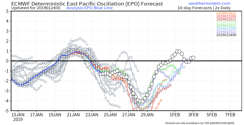
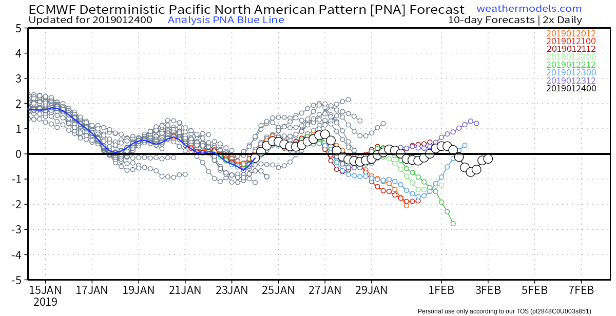
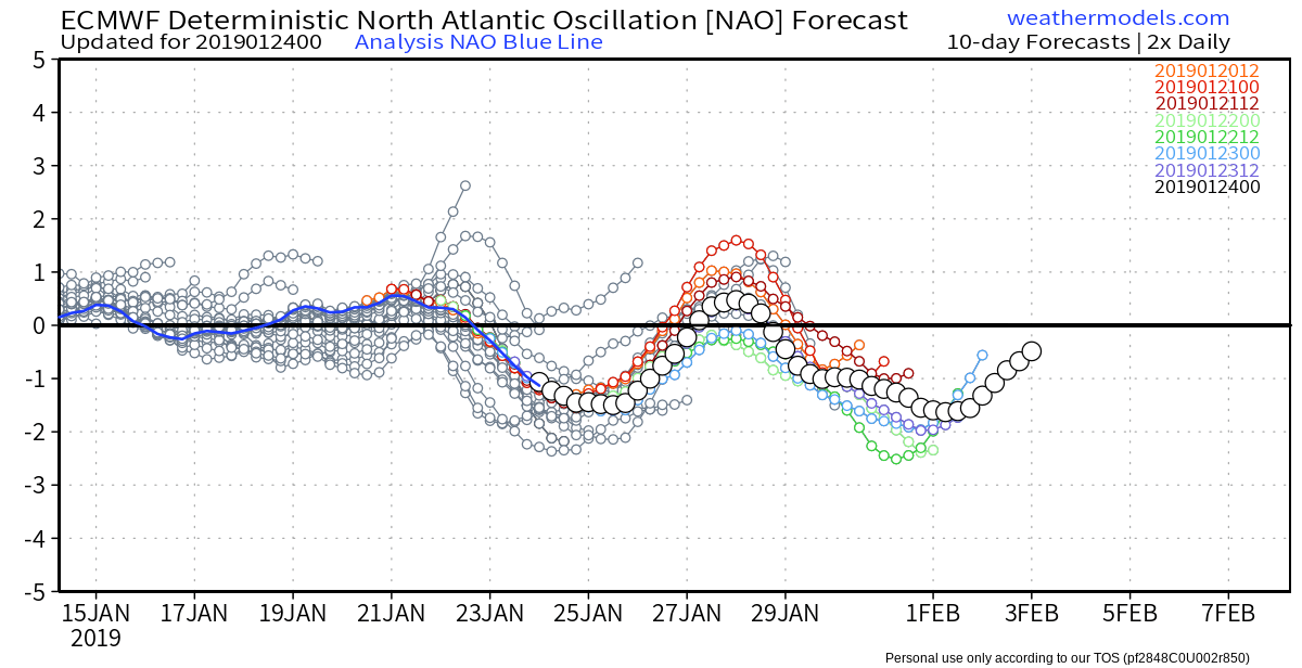
AO headed Pos EPO headed Pos PNA going Pos NAO stays primarilly Neg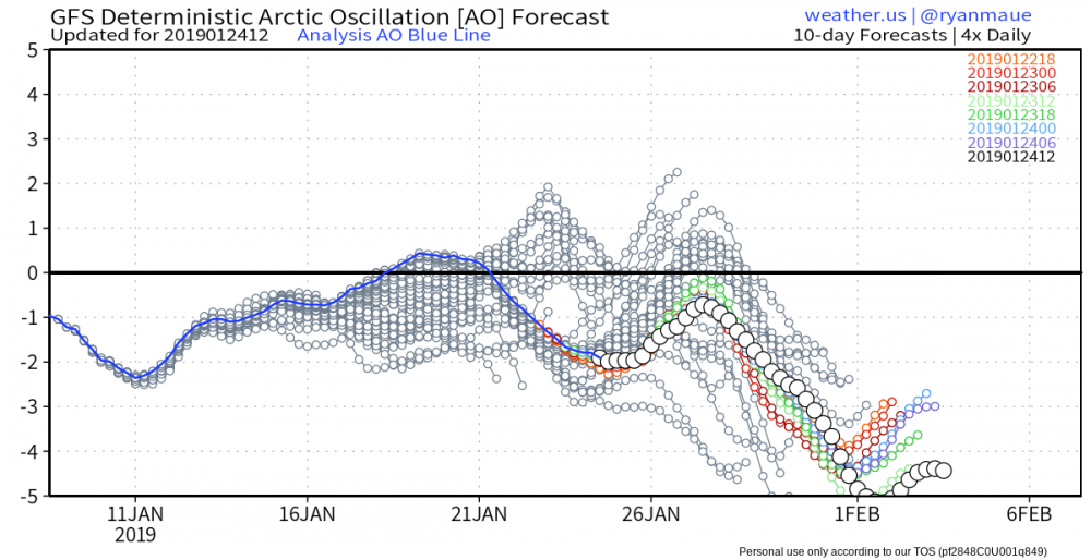


-
Upstate/Eastern New York
CNY-WXFREAK replied to BuffaloWeather's topic in Upstate New York/Pennsylvania
There's gonna be some surprises with this event for sure! -
Upstate/Eastern New York
CNY-WXFREAK replied to BuffaloWeather's topic in Upstate New York/Pennsylvania
126hr Euro much better SLP placement so I will side with the Euro for sure! I'll take the Euro for 1000 please!.thumb.png.f34230f934a36a0e6dc31f129d38083f.png)
.thumb.png.a07382ac801c603e00580d632b7e0f64.png)
-
Upstate/Eastern New York
CNY-WXFREAK replied to BuffaloWeather's topic in Upstate New York/Pennsylvania
I don't believe any of these models for this next little LE event so I wouldn't get your hopes up cause its a bad set-up and the reason being is the super transient nature of the bands as their super transient still and can't lock in for more than a few time! -
Upstate/Eastern New York
CNY-WXFREAK replied to BuffaloWeather's topic in Upstate New York/Pennsylvania
Euro's respectable event for Tues-Wed of next week can get a bit interesting, It's not a huge snow producer for the area, but its the only model that stays primarilly snow for the event. I'd be more inclined to believe the Euro over other guidance when we're within 4days so its a lock that we see something for tues-wed but we just need others to follow suit, Here's the Euro and it doesn't look bad at all and I think the Euro is Waaaayyyyy off with its band placement as these band are not going steady state for more than 6hrs in any one area, now I know totals have went down by half in some places! Bands are just too transient for blockbuster totals but we'll see:.thumb.png.4fc701743c571e429feed5b8335a385f.png)
.thumb.png.3f98b19ceca3168812c8642b053ff9f9.png)
.thumb.png.ac870eddcc534e7917a1422333e4db3b.png)
-
Upstate/Eastern New York
CNY-WXFREAK replied to BuffaloWeather's topic in Upstate New York/Pennsylvania
Their just covering their asses is all, as they haven't got a clue though, really! -
Upstate/Eastern New York
CNY-WXFREAK replied to BuffaloWeather's topic in Upstate New York/Pennsylvania
I think KBUF goes back to their original thoughts with excluding Wayne and Monroe Counties cause I cant see how, except for the AF with snow showers likely with passage, but other than that, I don't see it, that's just me! -
Upstate/Eastern New York
CNY-WXFREAK replied to BuffaloWeather's topic in Upstate New York/Pennsylvania
No one else knew about the 3" deluge we just received? Gotta love when they say rain, and it turns into a flooding rn, unreal, but when its supposed to snow heavy, we get pixie dust for flakes, lol! -
Upstate/Eastern New York
CNY-WXFREAK replied to BuffaloWeather's topic in Upstate New York/Pennsylvania
Check back tomorrow Matt as we'll have a better idea but I think Oswego is in a good, not great, spot for the event but tomorrow everything should be a lot clearer. -
Upstate/Eastern New York
CNY-WXFREAK replied to BuffaloWeather's topic in Upstate New York/Pennsylvania
I forgot its Wednesday, lol, thought it was Tuesday, forgot holiday!
.png.b27ac5b6659e20694230a9324046d763.png)
.png.f5ca87557480dc3e17bfb402bcae5714.png)
.png.0dfb309906d828a66907fe6f8c8c6a4f.png)


.png.712e95cf425e455ee9ffb54b5326ae36.png)
.png.bd43b19ec4b0b420fd1e8cbc17b1becd.png)
.png.37d82745b32b078e860ddfde5facf63a.png)
.png.6d2cfe191a3c234aadcda9566f6c106b.png)
.png.321160b52cdd41e216fae24585a08279.png)