TullyHeel
-
Posts
12,875 -
Joined
-
Last visited
Content Type
Profiles
Blogs
Forums
American Weather
Media Demo
Store
Gallery
Everything posted by TullyHeel
-
Looks like all the action in NC is north of 40 and moving NE.
-
Just saw I am under a severe storm warning until 4:15.
-
Severe Weather Statement National Weather Service Raleigh NC 349 PM EDT Thu Jun 20 2019 NCC037-202000- /O.CON.KRAH.SV.W.0096.000000T0000Z-190620T2000Z/ Chatham NC- 349 PM EDT Thu Jun 20 2019 ...A SEVERE THUNDERSTORM WARNING REMAINS IN EFFECT UNTIL 400 PM EDT FOR CHATHAM COUNTY... At 349 PM EDT, severe thunderstorms were located along a line extending from near Butner to 6 miles north of Pittsboro to 8 miles south of Siler City, moving east at 50 mph. HAZARD...70 mph wind gusts and quarter size hail. SOURCE...Emergency management reports numerous powerlines down across the City of Chapel Hill. IMPACT...Hail damage to vehicles is expected. Expect considerable tree damage. Wind damage is also likely to mobile homes, roofs, and outbuildings. Locations impacted include... Pittsboro, Siler City, Goldston, Crosswinds Boating Center, Crosswinds Campground, Harpers Crossroads, Jordan Lake State Rec Area, Bynum, Seaforth Boat Dock and Moncure.
-
Looking out the window here at work and the clouds look really ominous.
-
SEVERE WEATHER STATEMENT NATIONAL WEATHER SERVICE RALEIGH NC 309 PM EDT THU JUN 20 2019 NCC001-063-077-081-135-145-201930- /O.CON.KRAH.SV.W.0094.000000T0000Z-190620T1930Z/ ALAMANCE NC-PERSON NC-ORANGE NC-GRANVILLE NC-GUILFORD NC-DURHAM NC- 309 PM EDT THU JUN 20 2019 ...A SEVERE THUNDERSTORM WARNING REMAINS IN EFFECT UNTIL 330 PM EDT FOR ALAMANCE...EASTERN PERSON...ORANGE...GRANVILLE...SOUTHEASTERN GUILFORD AND DURHAM COUNTIES... AT 309 PM EDT, SEVERE THUNDERSTORMS WERE LOCATED ALONG A LINE EXTENDING FROM NEAR VIRGILINA TO 11 MILES NORTHEAST OF ROUGEMONT TO GRAHAM, MOVING EAST AT 50 MPH. HAZARD...70 MPH WIND GUSTS AND QUARTER SIZE HAIL. SOURCE...EMERGENCY MANAGEMENT REPORT NUMEROUS TREES AND POWERLINES DOWN ACROSS NORTH CENTRAL NORTH CAROLINA, ESPECIALLY PORTIONS OF PERSON COUNTY. IMPACT...HAIL DAMAGE TO VEHICLES IS EXPECTED. EXPECT CONSIDERABLE TREE DAMAGE. WIND DAMAGE IS ALSO LIKELY TO MOBILE HOMES, ROOFS, AND OUTBUILDINGS. LOCATIONS IMPACTED INCLUDE... DURHAM, CHAPEL HILL, BURLINGTON, GRAHAM, OXFORD, HILLSBOROUGH, CREEDMOOR, CARRBORO, MEBANE AND BUTNER. PRECAUTIONARY/PREPAREDNESS ACTIONS... STRAIGHT LINE WINDS CAN BLOW DOWN TREES, POWER LINES, AND DAMAGE MOBILE HOMES AND OTHER BUILDINGS. SEEK SHELTER IN A STURDY STRUCTURE UNTIL THE STORM HAS PASSED. STAY AWAY FROM WINDOWS AS FLYING DEBRIS GENERATED BY DAMAGING WINDS CAN BE DEADLY. TORRENTIAL RAINFALL IS OCCURRING WITH THESE STORMS, AND MAY LEAD TO FLASH FLOODING. DO NOT DRIVE YOUR VEHICLE THROUGH FLOODED ROADWAYS.
-
That is a huge area. Also saw the SPC was discussing a possible watch from VA to NY.
-
Well, that answers my question. GA up to VA under the gun.
-
Watch is out until 10:00 pm. Covers all of SC, most of GA, and some of NC. Weird border for NC. Wonder if we'll get another watch here.
-
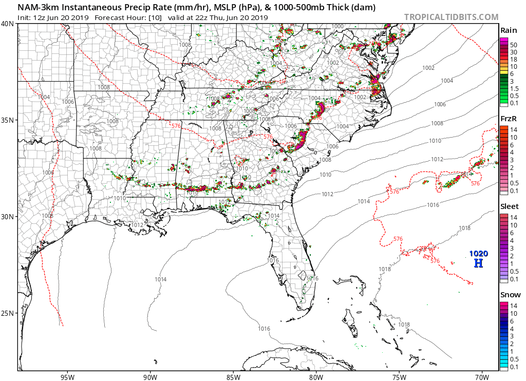
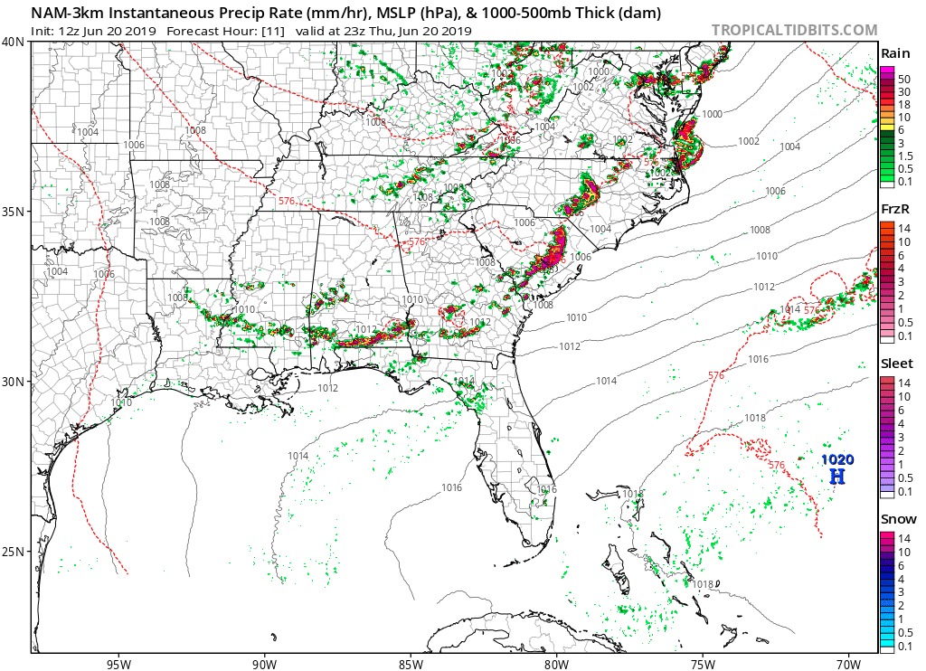
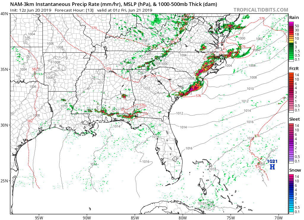
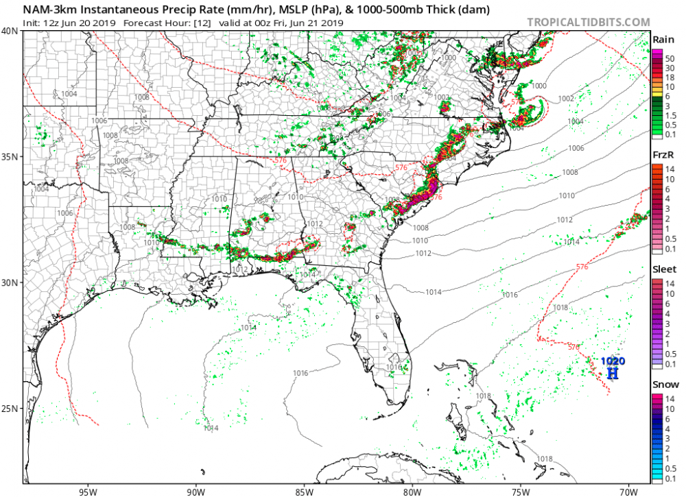
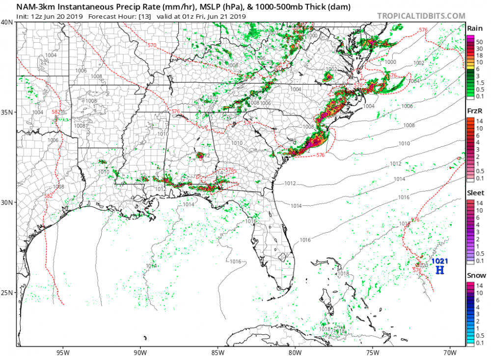
3K NAM looks scary for NC and SC.

-
Mesoscale Discussion 1160 NWS Storm Prediction Center Norman OK 1123 AM CDT Thu Jun 20 2019 Areas affected...North Carolina...Virginia...Maryland and Delaware Concerning...Severe potential...Watch likely Valid 201623Z - 201830Z Probability of Watch Issuance...80 percent SUMMARY...Thunderstorms are expected to develop during the early afternoon posing a risk for damaging wind and hail. A severe thunderstorm watch will probably be needed by 18-19Z. DISCUSSION...The warm sector continues to destabilize over a large part of the Mid Atlantic region from North Carolina through VA and MD. Surface dewpoints around 70F and temperatures warming through the mid to upper 80s have boosted MLCAPE to 1500-2000 J/kg. WV imagery shows the primary shortwave trough over the TN Valley, but with an MCV moving through the southern Appalachians. These features are progressive, and the accompanying forcing for ascent along with boundary layer destabilization should result in an increase in thunderstorm coverage and intensity this afternoon. Wind profiles are unidirectional west southwesterly with 30-40 kt deep-layer flow, but modest 0-6 km shear generally less than 35 kt. This environment will support mostly multicell modes, but mid-level updraft rotation will also be possible in some storms. Activity may evolve into clusters and line segments with time posing a risk for damaging wind and hail through the afternoon into early evening.
-
First watch coming soon. Mesoscale Discussion 1159 NWS Storm Prediction Center Norman OK 1102 AM CDT Thu Jun 20 2019 Areas affected...southeast Alabama...central and southern Georgia and South Carolina Concerning...Severe potential...Watch likely Valid 201602Z - 201800Z Probability of Watch Issuance...80 percent SUMMARY...Thunderstorms are expected to develop by 17-18Z over a large part of the Southeast U.S. and increase in coverage and intensity during the afternoon, posing a risk for damaging wind and hail. A WW will probably be needed for a portion of this region by 17Z. DISCUSSION...A moist warm sector resides over a large part of the southeast U.S. with dewpoints around 70F and temperatures climbing through the mid 80s F as of 16Z. Latest objective analysis indicate MLCAPE around 1500-2000 J/kg and further destabilization will occur as the surface layer continues to warm. Water vapor imagery shows a progressive shortwave trough moving through the TN Valley, with an MCV also indicated over southeast TN/northern GA. A low-level confluence zone is forecast to evolve well inland from the coast from southern AL through southern GA. The combination of forcing for ascent associated with the MCV and progressive shortwave trough, surface layer destabilization and subtle boundaries, should promote warm sector initiation by early afternoon. While deep-layer wind profiles are unidirectional west southwesterly with small 0-1 km hodographs, a belt of 50 kt mid-level winds within the base of the trough is resulting in 30-35 kt effective bulk shear. This environment should support both multicell and some supercell structures with discrete modes eventually evolving into lines and clusters capable of damaging wind and hail.
-
-
Possible tornado forming on this news feed. https://www.wwltv.com/live-video
-
Tornado warning for New Orleans now.
-
Louisiana is getting hit with tornadoes now. I guess it's not considered in the SE here, but I've been watching coverage from a station in New Orleans. They have a confirmed tornado with debris showing on radar. https://www.wwltv.com/live-video
-
Well, we had another severe thunderstorm watch last night, but nothing severe around me. Had heavy rain and some thunder. The biggest severe weather around here this year remains the tornadoes we had in May when we were not under any kind of watch.
-
I am talking specifically for Wake and what I have experienced. We have more severe storms when we are not under a watch than when we are the past few years for some reason. I am talking about comparing the severity of the storms, like when we had tornadoes earlier this month without any watch.
-
Still less severe compared to other storms we have had here the past few years when not under a watch.
-
And once again the storms are less severe here when we're under a watch versus when we aren't.
-
And so far everything is moving around Wake. Typical whenever we're under a watch.
-
Some warnings out now. https://forecast.weather.gov/wwamap/wwatxtget.php?cwa=rah&wwa=severe thunderstorm warning
-
Looks like a severe thunderstorm watch will be coming soon. Guess we'll have to see if we actually get anything severe with a watch this time, or if the streak of having more severe weather around here without a watch continues. Mesoscale Discussion 0909 NWS Storm Prediction Center Norman OK 1107 AM CDT Fri May 31 2019 Areas affected...western portions of VA/NC and the VA/NC Piedmont Concerning...Severe potential...Severe Thunderstorm Watch likely Valid 311607Z - 311800Z Probability of Watch Issuance...80 percent SUMMARY...Isolated to widely scattered thunderstorm development is forecast over the next 1-2 hours (12pm-2pm EDT) near the higher terrain over western NC and western/southwestern VA. Isolated storms may also develop over the Piedmont by 2pm EDT. DISCUSSION...Late morning water vapor imagery loop shows a mid-level shortwave trough over KY/TN and this feature is forecast to reach the southern Appalachians by mid afternoon. Visible satellite imagery shows a swelling cumulus field over the southern Appalachians immediately east of the eastward-migrating disturbance. Surface observations indicate temperatures have warmed to near 80 degrees F near the mountains and into the middle 80s over the NC Piedmont. Low-level moisture increases from west to east across NC with surface dewpoints near 60 degrees F in the west, low-middle 60s over the Piedmont, and upper 60s to near 70 in the coastal plain. Reflective of the low-level moisture field, buoyancy is forecast to be highest near and east of I-95 with 2000-2500 J/kg MLCAPE expected by late afternoon with steep 0-3km lapse rates. Strong heating will contribute to 1500-2000 J/kg MLCAPE farther west near the I-77 corridor by early afternoon. A belt of 30-35kt westerly 500mb flow will act to organize updrafts this afternoon beneath 60-80kt upper-level westerly flow. Despite weak low-level flow, elongated hodographs will favor the potential for splitting supercells and severe multicells capable of large hail and severe gusts (60mph). The propensity for wind damage will likely increase coincident with richer low-level moisture as storms move/grow upscale from west-central into east-central portions of NC later this afternoon into the early evening.
-
I liked the version before the current one a lot better.
-
I would love to see Matthew East at WRAL. As far as Fishel resigning, it really is bizarre. He was gone for about a month this same time last year, and they said it was a medical leave. This sounds really bad, and whatever is going on interfered with his job. I wonder if it is alcohol or drug related. Whatever it is, I hope he gets the help he needs and gets better. This is just a tremendous loss for WRAL and weather geeks in the Triangle area. I grew up watching Fishel, and he was a big reason why I became so interested in the weather.
-
Where's the storm thresd for this weekend? The FV3 is where it's at!