Brick Tamland
-
Posts
12,210 -
Joined
-
Last visited
Content Type
Profiles
Blogs
Forums
American Weather
Media Demo
Store
Gallery
Everything posted by Brick Tamland
-

Mid to Late May 2019 Severe Threats
Brick Tamland replied to Quincy's topic in Central/Western States
News 9 said it was on the ground for 15 to 18 miles and a half mile wide. -
Mid to Late May 2019 Severe Threats
Brick Tamland replied to Quincy's topic in Central/Western States
Coming into Laverne, OK -
Mid to Late May 2019 Severe Threats
Brick Tamland replied to Quincy's topic in Central/Western States
Live feed from News 9 in OKC. https://kwtv-lh.akamaihd.net/i/KWTV_1256@91154/master.m3u8 -
Mid to Late May 2019 Severe Threats
Brick Tamland replied to Quincy's topic in Central/Western States
Got it. Here's the link. https://www.severestudios.com/storm-chasers/corey.inmon.html -
Mid to Late May 2019 Severe Threats
Brick Tamland replied to Quincy's topic in Central/Western States
How are you watching it? -
Mid to Late May 2019 Severe Threats
Brick Tamland replied to Quincy's topic in Central/Western States
-
Mid to Late May 2019 Severe Threats
Brick Tamland replied to Quincy's topic in Central/Western States
Another one for northern OK and southern KS. Mesoscale Discussion 0752 NWS Storm Prediction Center Norman OK 0142 PM CDT Thu May 23 2019 Areas affected...Southern Kansas and Northern Oklahoma Concerning...Severe potential...Watch likely Valid 231842Z - 231945Z Probability of Watch Issuance...80 percent SUMMARY...Convective initiation occurring along/south of a warm front. Large hail is the primary threat, and a few tornadoes are possible south/near the front. Watch likely, though timing uncertain. DISCUSSION...Regional surface observations and objective mesoanalysis shows an east/west oriented warm front over the northern tier of counties in Oklahoma, moving quickly northward, on the precipice of entering southern Kansas. Regional satellite shows boundary-layer cumulus developing along the front and steadily obtaining greater vertical depth. Regional radar shows weak echoes with this activity. It appears this will be a mechanism for convective development over the next few hours. Storms that develop along the front should become quickly elevated, although any storms that linger or are able to ride along the boundary could pose a tornado threat. However, the thermodynamic/kinematic environment north of the boundary is quite support of large hail (MUCAPE 2000-2500 J/kg and effective shear 50-55 kt). South of the warm front, additional convective development is possible in the warm sector. Here, temperatures are in the low 80s F with dew points in the low 70s F. Any storms that develop here will also pose a large hail threat. A tornado threat will also exist with this activity that resides in the warm sector or as it crosses the warm front. A watch is being considered for this region, however the timing of watch issuance remains uncertain. -
Mid to Late May 2019 Severe Threats
Brick Tamland replied to Quincy's topic in Central/Western States
Mesoscale Discussion 0753 NWS Storm Prediction Center Norman OK 0147 PM CDT Thu May 23 2019 Areas affected...TX Panhandle...Far Western OK Concerning...Severe potential...Watch likely Valid 231847Z - 232045Z Probability of Watch Issuance...95 percent SUMMARY...Supercell thunderstorms capable of all severe hazards, including very large hail and tornadoes, are expected to develop across the TX Panhandle this afternoon. DISCUSSION...Based on the wind fields in the 18Z observations a triple point/surface low exists just west of AMA with the thermal fields indicating a dryline extends southwestward to HOB. Another low appears to exist northeast of AMA (near BGD), with a warm front extending northeastward to the central KS/OK border. Strong moisture convergence continues in the vicinity of AMA as the composite outflow/cold front continues to sag slowly southeastward while strong southeasterly surface winds and moisture advection continues south of it. The air mass along and south/east of these boundaries continues to destabilize. Cumulus field across east-central NM/western TX Panhandle continues to deepen and the 18Z AMA sounding shows very little convective inhibition remaining. Overall expectation is for convective initiation to occur around 20Z. An initially discrete mode is anticipated, with supercells capable of all severe hazards likely. Tornadoes and very large hail (i.e. greater than 2" in diameter) may occur, particularly as storms move east/northeastward into the central and eastern TX Panhandle where surface winds are more southeasterly. Given the strength of the low-level shear, a strong, long-track tornado may occur if storms are able to remain discrete enough and do not grow upscale.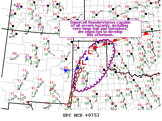
-
Mid to Late May 2019 Severe Threats
Brick Tamland replied to Quincy's topic in Central/Western States
-
Mid to Late May 2019 Severe Threats
Brick Tamland replied to Quincy's topic in Central/Western States
The size of the tornado that went through Jefferson City was amazing. Crazy how yesterday was worse than Monday when Monday's threat received all the hype beforehand. Yesterday went from a 0 to a 10 in just a couple of hours. -
Mid to Late May 2019 Severe Threats
Brick Tamland replied to Quincy's topic in Central/Western States
Just heard a Skywarn spotter say large tornado on the ground. -
Mid to Late May 2019 Severe Threats
Brick Tamland replied to Quincy's topic in Central/Western States
-
Mid to Late May 2019 Severe Threats
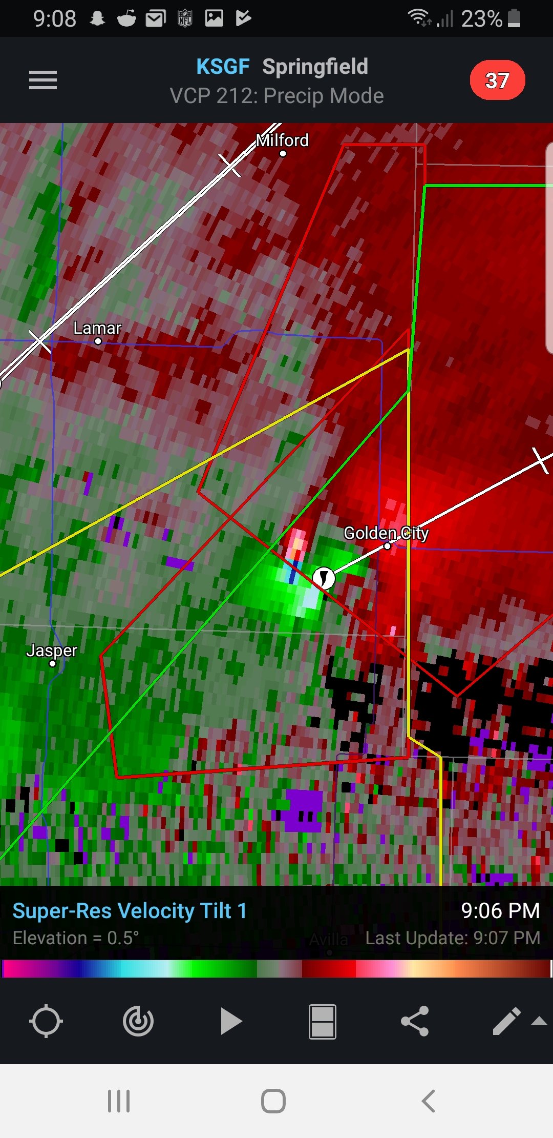
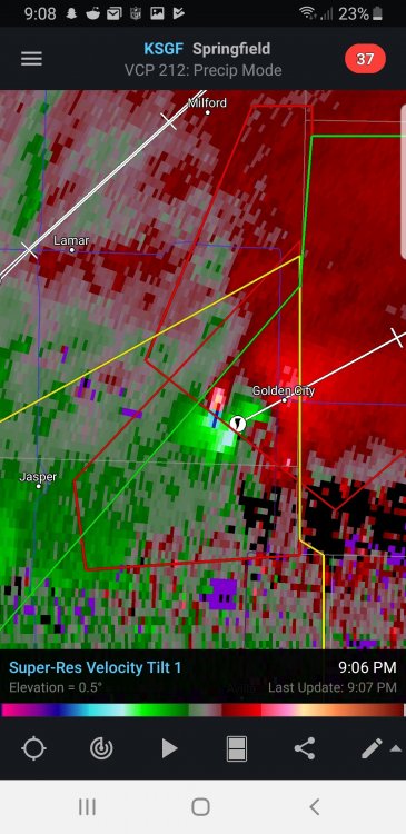
Brick Tamland replied to Quincy's topic in Central/Western States
Looks like Golden City is going to get a direct hit. -
Mid to Late May 2019 Severe Threats
Brick Tamland replied to Quincy's topic in Central/Western States
Brett Adair has a tornado in OK. Brett Adair is currently chasing a storm on Live Storm Chasing! https://livestormchasing.com/stream/7ltMkVSU9UtN61jdA52L -
Mid to Late May 2019 Severe Threats
Brick Tamland replied to Quincy's topic in Central/Western States
Heard on the scanner feed there is damage in Vernon County, MO. -
Mid to Late May 2019 Severe Threats
Brick Tamland replied to Quincy's topic in Central/Western States
The feed for Jeff Piotrowski looks very ominous. https://www.pscp.tv/w/b7Xu8TFNV0V3TXpHYldrS2J8MU1ueG52em5uUm14TyToRGMkjgw0aarVrSn85KBoiyjifWi67kz4XcNHeo9h -
Mid to Late May 2019 Severe Threats
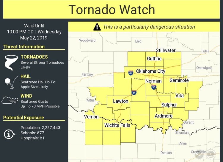
Brick Tamland replied to Quincy's topic in Central/Western States
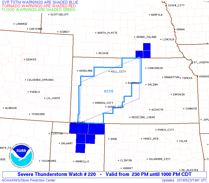
URGENT - IMMEDIATE BROADCAST REQUESTED Tornado Watch Number 212 NWS Storm Prediction Center Norman OK 330 PM CDT Wed May 22 2019 The NWS Storm Prediction Center has issued a * Tornado Watch for portions of Southeast Kansas Central and Southwest Missouri Northeast Oklahoma * Effective this Wednesday afternoon and evening from 330 PM until 1100 PM CDT. ...THIS IS A PARTICULARLY DANGEROUS SITUATION... * Primary threats include... Several tornadoes and a few intense tornadoes likely Widespread large hail and scattered very large hail events to 3 inches in diameter likely Scattered damaging wind gusts to 70 mph likely SUMMARY...Thunderstorms are expected to develop across the watch area this afternoon and spread northeastward through the evening. Supercells capable of very large hail, damaging winds, and strong tornadoes are possible. The tornado watch area is approximately along and 80 statute miles north and south of a line from 60 miles west southwest of Tulsa OK to 60 miles east northeast of Knob Noster MO. For a complete depiction of the watch see the associated watch outline update (WOUS64 KWNS WOU2). -
Mid to Late May 2019 Severe Threats
Brick Tamland replied to Quincy's topic in Central/Western States
Mesoscale Discussion 0734 NWS Storm Prediction Center Norman OK 0306 PM CDT Wed May 22 2019 Areas affected...Northeast Oklahoma...Southeast Kansas...Southwest Missouri...and Northwest Arkansas Concerning...Severe potential...Watch likely Valid 222006Z - 222200Z Probability of Watch Issuance...95 percent SUMMARY...Supercells capable of large hail, damaging winds, and tornadoes -- a few of which may be strong -- are expected. A tornado watch is likely. DISCUSSION...Visible satellite shows boundary layer cumulus developing over portions of northeast Oklahoma, southeast Kansas, northwest Arkansas, and southwest Missouri, as low-level moisture advects northward across the region. Surface dew points in the low 70s F are overspreading the region, ahead of a stalled cold front. Along the front, elevated convection has developed and is moving parallel to the boundary. With continued diabatic heating and low-level moisture advection, further destabilization can be expected, with MLCAPE values of 3000-4000 J/kg developing by late afternoon. Given these thermodynamic conditions, convective initiation is expected within the next 1-2 hours. Convection along the front may eventually root into the boundary layer, and additional storms may develop in the warm sector, particularly in southern parts of the MCD area. As storms develop, effective bulk shear of 50-55 kt will help organize the convection into supercell structures. With effective SRH exceeding 200 m^2/s^2, tornadoes -- a few of which could be strong -- are possible, along with the threat for large hail and damaging winds. A tornado watch will likely be issued within the next hour. ..Karstens/Hart.. 05/22/2019 -
Mid to Late May 2019 Severe Threats
Brick Tamland replied to Quincy's topic in Central/Western States
-
Mid to Late May 2019 Severe Threats
Brick Tamland replied to Quincy's topic in Central/Western States
URGENT - IMMEDIATE BROADCAST REQUESTED Tornado Watch Number 211 NWS Storm Prediction Center Norman OK 230 PM CDT Wed May 22 2019 The NWS Storm Prediction Center has issued a * Tornado Watch for portions of Southwest and Central Oklahoma Western North Texas * Effective this Wednesday afternoon and evening from 230 PM until 1000 PM CDT. ...THIS IS A PARTICULARLY DANGEROUS SITUATION... * Primary threats include... Several tornadoes and a few intense tornadoes likely Scattered large hail likely with isolated very large hail events to 3 inches in diameter possible Scattered damaging wind gusts to 70 mph possible SUMMARY...Isolated intense thunderstorms are expected to affect the watch area this afternoon and early evening. Any storm that persists will pose a risk of strong tornadoes, very large hail, and damaging winds. The tornado watch area is approximately along and 60 statute miles north and south of a line from 25 miles south of Altus OK to 45 miles south southeast of Chandler OK. For a complete depiction of the watch see the associated watch outline update (WOUS64 KWNS WOU1).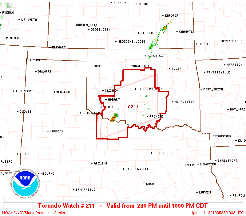
-
Mid to Long Term Discussion 2019
Brick Tamland replied to Upstate Tiger's topic in Southeastern States
Well, guess we are in the boring part of the year with regards to weather here. Looking forward to going to the beach, lake, and amusement parks this summer. But have to hang out at the midwest forum to get my severe weather fix. -
Mid to Long Term Discussion 2019
Brick Tamland replied to Upstate Tiger's topic in Southeastern States
Summer officially started Monday. That's when I saw the first lightning bug of the year. -
Mid to Late May 2019 Severe Threats
Brick Tamland replied to Quincy's topic in Central/Western States
I agree with all of this. All it takes is one big one to do damage, and it seems more often than not that happens lately when it's not super hyped like Monday was. -
This could be said for just about any kind of storm potential the last few years, whether it be a severe potential or a possible winter storm, at least for my area. The models can't seem to handle anything but mundane weather, and the weather just doesn't do the same things it used to do when it comes to big storms. I know that's been the case for winter weather here in my area, and ever since the April 2011 tornado outbreak we end up getting more numerous and severe storms when we're not under a watch versus when we are.
-
Mid to Late May 2019 Severe Threats
Brick Tamland replied to Quincy's topic in Central/Western States
There's the watch.