Brick Tamland
-
Posts
12,210 -
Joined
-
Last visited
Content Type
Profiles
Blogs
Forums
American Weather
Media Demo
Store
Gallery
Everything posted by Brick Tamland
-
I am talking specifically for Wake and what I have experienced. We have more severe storms when we are not under a watch than when we are the past few years for some reason. I am talking about comparing the severity of the storms, like when we had tornadoes earlier this month without any watch.
-
Still less severe compared to other storms we have had here the past few years when not under a watch.
-
And once again the storms are less severe here when we're under a watch versus when we aren't.
-
And so far everything is moving around Wake. Typical whenever we're under a watch.
-
Some warnings out now. https://forecast.weather.gov/wwamap/wwatxtget.php?cwa=rah&wwa=severe thunderstorm warning
-
Looks like a severe thunderstorm watch will be coming soon. Guess we'll have to see if we actually get anything severe with a watch this time, or if the streak of having more severe weather around here without a watch continues. Mesoscale Discussion 0909 NWS Storm Prediction Center Norman OK 1107 AM CDT Fri May 31 2019 Areas affected...western portions of VA/NC and the VA/NC Piedmont Concerning...Severe potential...Severe Thunderstorm Watch likely Valid 311607Z - 311800Z Probability of Watch Issuance...80 percent SUMMARY...Isolated to widely scattered thunderstorm development is forecast over the next 1-2 hours (12pm-2pm EDT) near the higher terrain over western NC and western/southwestern VA. Isolated storms may also develop over the Piedmont by 2pm EDT. DISCUSSION...Late morning water vapor imagery loop shows a mid-level shortwave trough over KY/TN and this feature is forecast to reach the southern Appalachians by mid afternoon. Visible satellite imagery shows a swelling cumulus field over the southern Appalachians immediately east of the eastward-migrating disturbance. Surface observations indicate temperatures have warmed to near 80 degrees F near the mountains and into the middle 80s over the NC Piedmont. Low-level moisture increases from west to east across NC with surface dewpoints near 60 degrees F in the west, low-middle 60s over the Piedmont, and upper 60s to near 70 in the coastal plain. Reflective of the low-level moisture field, buoyancy is forecast to be highest near and east of I-95 with 2000-2500 J/kg MLCAPE expected by late afternoon with steep 0-3km lapse rates. Strong heating will contribute to 1500-2000 J/kg MLCAPE farther west near the I-77 corridor by early afternoon. A belt of 30-35kt westerly 500mb flow will act to organize updrafts this afternoon beneath 60-80kt upper-level westerly flow. Despite weak low-level flow, elongated hodographs will favor the potential for splitting supercells and severe multicells capable of large hail and severe gusts (60mph). The propensity for wind damage will likely increase coincident with richer low-level moisture as storms move/grow upscale from west-central into east-central portions of NC later this afternoon into the early evening.
-

Mid to Late May 2019 Severe Threats
Brick Tamland replied to Quincy's topic in Central/Western States
Rope tornado according to law enforcement in Canton, TX. -
Mid to Late May 2019 Severe Threats
Brick Tamland replied to Quincy's topic in Central/Western States
Crazy the way the last two weeks how fast the storms blow up and produce tornadoes. -
Mid to Late May 2019 Severe Threats
Brick Tamland replied to Quincy's topic in Central/Western States
Law enforcement confirmed tornado on the ground. -
Mid to Late May 2019 Severe Threats
Brick Tamland replied to Quincy's topic in Central/Western States
Van Zandt County, TX scanner feed. https://scannerradio.app/?l=NjAyOTI -
Mid to Late May 2019 Severe Threats
Brick Tamland replied to Quincy's topic in Central/Western States
I wonder if the SPC will upgrade anywhere to a moderate risk today. -
Mid to Late May 2019 Severe Threats
Brick Tamland replied to Quincy's topic in Central/Western States
Where exactly did the tornado hit that was in the video showing damage? The tornado looked massive. -
Pittsburgh PA Area Spring and Summer 2019
Brick Tamland replied to CranberryWX's topic in Upstate New York/Pennsylvania
Pretty good rotation showing up near Pikes Peak, PA. -
Pittsburgh PA Area Spring and Summer 2019
Brick Tamland replied to CranberryWX's topic in Upstate New York/Pennsylvania
WTAE reporting circulation going right over Indiana, PA. -
Well, we have seen the last few weeks that you don't need a moderate or high risk to get a bunch of tornadoes.
-
Tornado watch up covering the moderate risk area. URGENT - IMMEDIATE BROADCAST REQUESTED Tornado Watch Number 275 NWS Storm Prediction Center Norman OK 155 PM CDT Tue May 28 2019 The NWS Storm Prediction Center has issued a * Tornado Watch for portions of Northeastern Kansas Northwestern Missouri * Effective this Tuesday afternoon and evening from 155 PM until 1000 PM CDT. * Primary threats include... A few tornadoes likely with a couple intense tornadoes possible Widespread large hail and scattered very large hail events to 3 inches in diameter likely Widespread damaging winds and isolated significant gusts to 80 mph likely SUMMARY...Initially elevated storms could become rooted near the surface along a slow-moving front from northeastern Kansas into northern Missouri this afternoon. Additional storms are expected to form and spread northeastward into the watch area from the southwest by mid-late afternoon. Supercells are expected with very large hail and potentially a few tornadoes, especially with storms able move along the front. Upscale growth into a cluster is also possible late this afternoon/evening, with an increasing threat for damaging winds. The tornado watch area is approximately along and 50 statute miles north and south of a line from 35 miles south southeast of Kirksville MO to 25 miles south southwest of Manhattan KS. For a complete depiction of the watch see the associated watch outline update (WOUS64 KWNS WOU5).
-
Mid to Late May 2019 Severe Threats
Brick Tamland replied to Quincy's topic in Central/Western States
That's not even in the moderate risk area. -
Listening to the Dayton scanner feed. They are still going door to door to see if people were hurt. Heard some say structures were completely flattened.
-
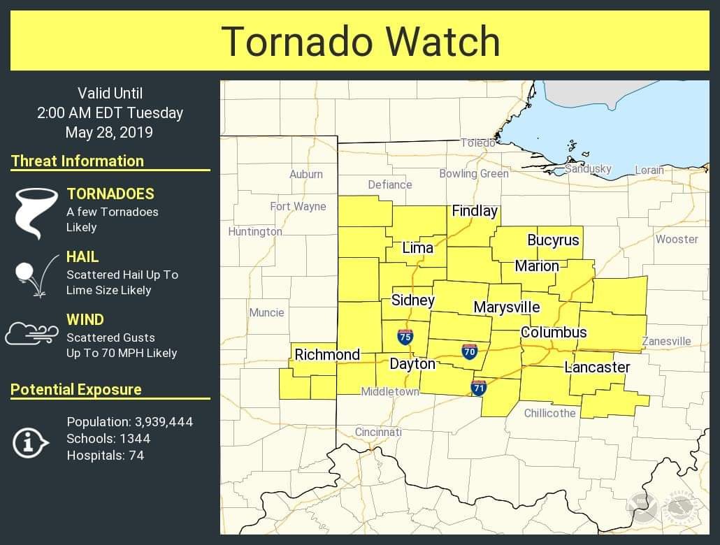
What a crazy night for Ohio, and for the last two weeks overall in regards to tornadoes. I don't recall the last time a large tornado hit Ohio. Don't think of them as a typical area to get tornadoes. Last week it was the midwest, typical tornado alley spots that got hit. Before that it was the SE. This has been a bad month for tornadoes.
-

-
Listening to the scanner feed for Madison County, IN. Sounds like they got hit hard.
-
Mid to Late May 2019 Severe Threats
Brick Tamland replied to Quincy's topic in Central/Western States
Also feels like it is getting harder to predict the actual level of threat for tornadoes. -
Mid to Late May 2019 Severe Threats
Brick Tamland replied to Quincy's topic in Central/Western States
OK, TX, and MO were really lucky this week that these tornadoes didn't do more damage and hit more populated areas. Been a while since we've had a week like this with all the tornado threats. -
Mid to Late May 2019 Severe Threats
Brick Tamland replied to Quincy's topic in Central/Western States
-
Mid to Late May 2019 Severe Threats
Brick Tamland replied to Quincy's topic in Central/Western States
KFOR said it lifted before Laverne.