

Brick Tamland
-
Posts
12,210 -
Joined
-
Last visited
Content Type
Profiles
Blogs
Forums
American Weather
Media Demo
Store
Gallery
Posts posted by Brick Tamland
-
-
Just now, greendave said:
I'll leave this here....posted at 11am.

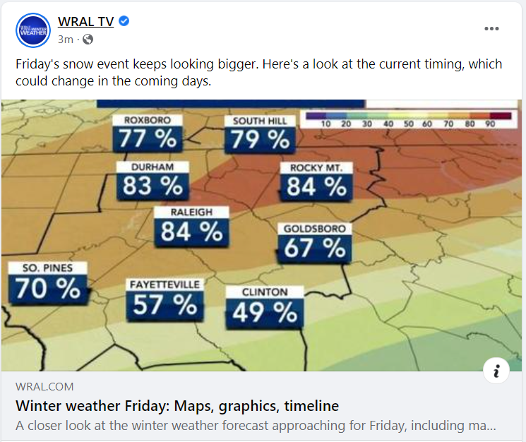
That map is stupid.
-
 2
2
-
-
4 minutes ago, olafminesaw said:
.thumb.png.9d6e5a124bb32c2b8ae8e93eecc06fd9.png)
Looks good, just smaller totals than the Euro had.
-
Hope Goofus can move us back from the edge of the cliff.
-
15 minutes ago one of the WRAL mets said the NAM was an awful model but still agreeing with the globals.

-
1 minute ago, mclean02 said:
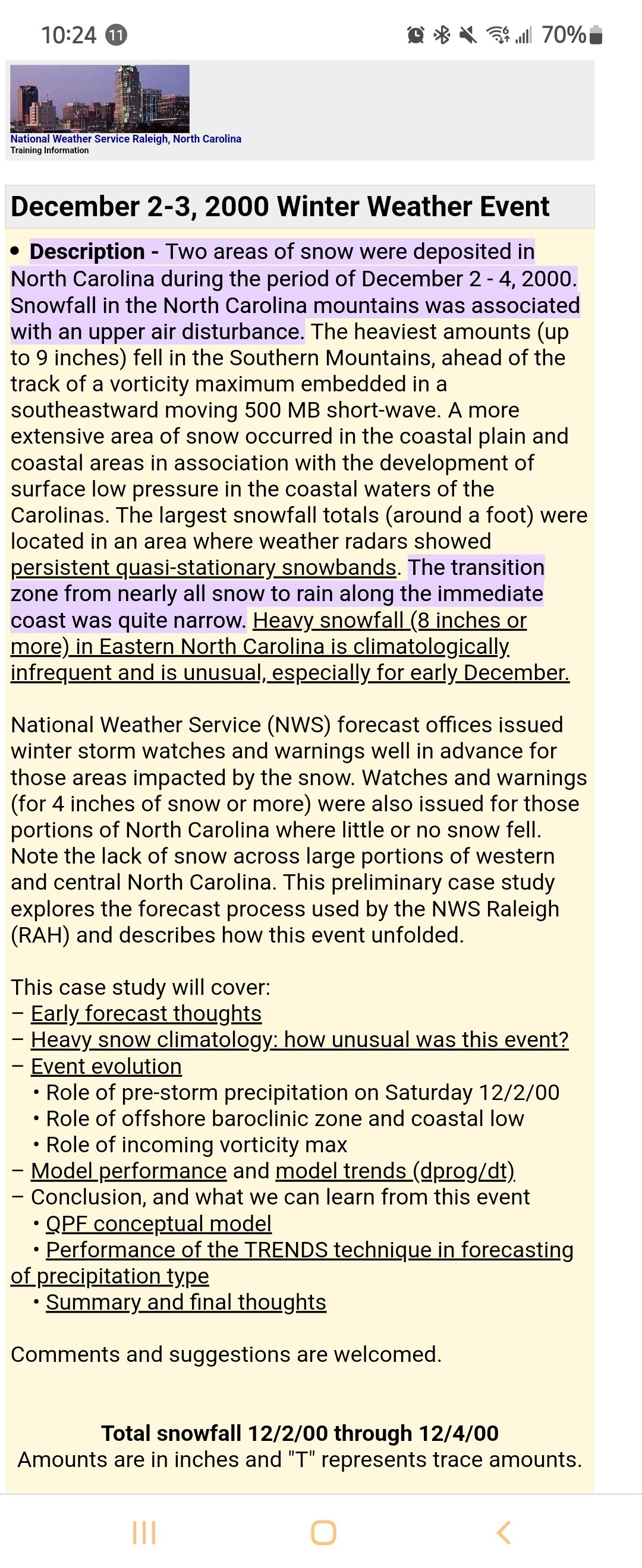
I can't help but keep thinking about what happened in December 2000 in Triad. Not treading well for this area.
You would think the globals would be better 22 years later.
-
Man, even the Triangle has to worry about it going too far east if we want some decent snow amounts. Last weekend it was too far west for us, and now this just 48 hours out.
-
 2
2
-
-
-
3 minutes ago, wxdawg10 said:
Dude..you sing this same song everytime. Models are tools. experienced Mets who are paid for this look at science not just models. stop living and dying by models and their effectiveness.
Just saying when all the globals line up 48 hours out and if it doesn't happen that's not a good look.
-
1
-
-
If this falls apart 48 hours out the globals will never be trusted again for winter storms around here.
-
1
-
 1
1
-
-
Still looks okay for the eastern part of NC.
-
1
-
 1
1
-
-
NAM looks to be coming in good.
-
6 minutes ago, msuwx said:
The Charlotte metro and surrounding area is an incredibly difficult call as it all hinges on a very subtle (in the overall scheme of the atmosphere) NW expansion of the back edge of the snow shield. I mean these are very small differences when looking at the atmosphere as a whole, but the result has been very wild swings in possible snow totals in that part of the region, even just over the course of the 0z and 6z runs.
6z vs. 0z Euro:
.thumb.png.82193007c48d05120838625b8d61a769.png)
Do you still think your overall thoughts from yesterday with the map are the same?
-
Wow, Euro still looks great, especially the Kuchera map.
-
1
-
-
Euro was magnificent last night.
-
2
-
-
Greg Fishel's thoughts.
OK, NOW THAT I'VE RETURNED TO HOME BASE, LET'S TALK ABOUT THIS NEXT STORM!
One thing that is clearly different about this one is that the cold air is going to blast in, and this time it's gonna stick around for the duration of the storm. At this point in time, I honestly believe that everything the Triangle area receives from Thursday night through Friday night will be in the frozen form. And yes it is possible it will be all snow, but I'm not ready to make a commitment on that just yet. Whereas the last system was rapidly intensifying and cutting inland across the southeastern states, this storm will be offshore and weaker, allowing the cold air to make it all the way to the coast. We could even see freezing rain here in Myrtle Beach!
Another thing that's tricky about this one is that instead of a precipitaton shield moving in from another location, in this case it will be developing almost right over us. It's much easier to watch a ball rolling toward you at a certain speed, and estimate when the ball will get to you. It's an entirely different matter when the ball suddenly appears in front of you, and you have to react quickly! Will this storm be a series of weak waves of low pressure, or will there be a consolidation of atmospheric efforts leading to one main surface low pressure area? These are the issues for this particular event, and it will probably be another 24 hours before I feel some degree of confidence as to how weather conditions will evolve late in the week.
One thing for sure, I won't have to travel 300 miles to see winter weather this time. Mother nature is going to save me a ton of gas money!
-
2
-
1
-
-
2 minutes ago, Berlin1926 said:
I hope i'm wrong but everyone may get a whole lot of nuttin'. 2 days out and models still all over the place. I see a lot of wishcasting. Again, I hope I'M WRONG but there's a tiny window for Southern snow/ice etc., and this isn't it.
Not sure how they are all over the place. They have all showed today the highest accumulations between Charlotte northeast through the Triangle and into SE VA.
-
4
-
-
Can we take a blend of all the models and call it a day?
-
3
-
1
-
-
2 minutes ago, CaryWx said:
Not crazy about these northwest jumps and 850 lines creeping back
I think we're good.
-
Just now, Sandstorm94 said:
 everybody in the forum sayyyy
HERE COMES THE BOOM
Sent from my SM-S115DL using Tapatalk

-
3
-
1
-
-
Models really look good for Charlotte northeast through the Triangle and up to SE VA. They are showing a definite consensus with the heaviest totals in that area. So, either the models are going to be totally off or they start falling apart 48 hours out if this doesn't happen.
-
I think we're seeing a consensus with the models.

-
1
-
 2
2
-
-
Someone tell WRAL to not jump on the snow bandwagon and ruin it again.
-
6
-
-
1 minute ago, CaryWx said:
ugh, that Wake county gradient
You should move to Wake Forest. Everyone else is.
-
NAM looks amazing
-
3
-
.png.2ac309fe8be0308af26695974f43d2b9.png)

.png.d144092c116918385d343abeecaec46e.png)
January 20-22 “bring the mojo” winter storm threat
in Southeastern States
Posted
He might end up being right, but nothing on the models suggested anything he has been saying the last few days until this morning. Up until now all the globals were pretty much the same with the storm the last couple of days. If he's right it'll be based on "Oh, it always shifts NW" more than anything else. I think he's been doing some bittercasting during this one for some reason.