

Brick Tamland
-
Posts
12,210 -
Joined
-
Last visited
Content Type
Profiles
Blogs
Forums
American Weather
Media Demo
Store
Gallery
Posts posted by Brick Tamland
-
-
The snow train is coming.

-
 2
2
-
-
Wow, all three showing almost the exact same setup and totals.
-
Can we really get 3 models showing the same storm this far out?
-
5 minutes ago, NorthHillsWx said:
We’ll forget this map in 4 days when we’re staring down another 34 degree rain
Please take that negative energy to the sanatorium.
-
 4
4
-
 1
1
-
-
12 minutes ago, snowinnc said:
Why do I feel like being in the bullseye this far out is a bad thing? It’s pretty to look at but there is no way central NC ends up with that much.
Why not?
-
Tomorrow is just setting the stage for the real good stuff.
-
3
-
-
-
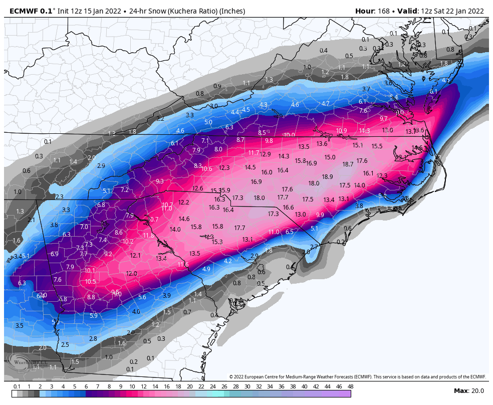
21 minutes ago, Sandstorm94 said:
Here is the 24 hour Kuchera for that storm

Sent from my SM-S115DL using Tapatalk

-
3
-
-
Hope this one is for real. Looks like what the models were showing for tomorrow's storm a week out, and we know how that turned out.
But I am going to stay positive. Let's get this!
-
2
-
-
Anyone got a pic of the CMC?
Hope next weekend is a legit shot at snow here and not this mix to rain crap. We usually get 3 shots at snow at the most for my area. I think anything 3 inches or more would be considered a good storm since we only average about 6 inches of snow here for winter.
-
1 minute ago, lilj4425 said:
I Hope you get soo much snow that you’re trapped in your house for a month.

With a 14 year old son, a 12 year old daughter, and a wife that are all redheads, three dogs, and a cat.

-
1
-
-
So, the January 2000 Carolina Crusher happened because the models showed the track of the system was too far off the coast, meaning no precip. This one the models say will be too far inland, causing the air to warm too much for snow.
-
4 minutes ago, lilj4425 said:
In the storm thread: Raleigh this, Raleigh that. Raleigh, Raleigh, Raleigh.

-
1
-
-
8 minutes ago, StantonParkHoya said:
Patterns are only good if they deliver. If it's not going to snow, I would prefer 60s and 70s.
AMEN!
-
1
-
1
-
-
2 minutes ago, TARHEELPROGRAMMER88 said:
Great, more cold rain. NW trends commence.
This thread is your friend.
-
2
-
1
-
1
-
-
8 minutes ago, franklin NCwx said:
Most of NC= Raleigh
No, besides the mountains, most of NC is not getting pure snow. Most of NC will get sleet, freezing rain, and rain if the forecast is right. I usually do better than Raleigh with snow because I am further north.
-
 2
2
-
-
6 minutes ago, msuwx said:
It’s weird to me how this board can be lit up like a Christmas tree analyzing the Day 8 NAVGEM, but now that a major storm is about to hit many, many people in the region, the post frequency tails off.
Is it because the storm isn’t producing pure snow for many? Eastern NC getting the short end of the stick?
To me, this is pretty easily the most significant winter storm, per capita, in a few years.
I think it's simply because most of NC isn't getting pure snow, and half the posters are from here. They checked out and are looking for the next storm.
-
6
-
-
11 minutes ago, NorthHillsWx said:
This one interests me a lot. For one, it’s a southern stream system. We are not relying on the northern stream to dump it far enough south. Also, it has ample cold air to work with. And for now, there appears to be blocking showing up north of it. As good a long range look as you can ask for at this point. Hopefully we start to see some agreement in the coming days
Yeah, hopefully it doesn't go to crap like tomorrow's storm. That one looked good just 6 days out, too.
-
1
-
1
-
-
Only a week away. Maybe this is the one for central NC.

-
2
-
1
-
1
-
-
I would love to see in the past 12 years how often areas in other states further south than the Triangle have gotten more snow than here.
-
1
-
-
18 minutes ago, snowmaker13 said:
Let's just be grateful that many are getting winter precip they havent gotten in many years. Let's turn negative vibes into positive ones!


-
5 minutes ago, Upstate Tiger said:
From GSP AFD
"In classic Carolina winter storm fashion, cold air will be
reinforced, if not enhanced Sunday morning by developing classical
(or at least strong hybrid) cold air damming, as 1030-ish mb surface
high pressure moves into New England beneath confluent upper flow."
I know some are disappointed but for the older ones on the board, this is a classic SE winter storm that we experienced so often in the 60's, 70's, and 80's. Unless you were in the mountain, you got a few inches of snow, followed by sleet, and then freezing rain. You wake up the next day to a winter wonderland with the pines all encrusted in snow and ice.
I remember those storms well growing up in Durham in the 80s. But today those storms usually end here as more rain than anything else.
-
7 hours ago, lilj4425 said:
I hope Brick gets three feet of snow.


-
1
-
-
It's crazy how hard it is too get snow here in the Triangle. Not enough precip, temps at 33 and rain, temps in the 20s but the track is too far inland and causes the temos to rise, warm nose, etc, etc.
-
1
-
January 20-22 “bring the mojo” winter storm threat
in Southeastern States
Posted
This needs to be in the banter and whining thread.