

TPAwx
-
Posts
447 -
Joined
-
Last visited
Content Type
Profiles
Blogs
Forums
American Weather
Media Demo
Store
Gallery
Posts posted by TPAwx
-
-
7 minutes ago, Hotair said:
Crap! Euro really wants to end Tampa’s streak of cane free seasons.
my South Tampa home will be under water if Ian does anything remotely like this model insists on.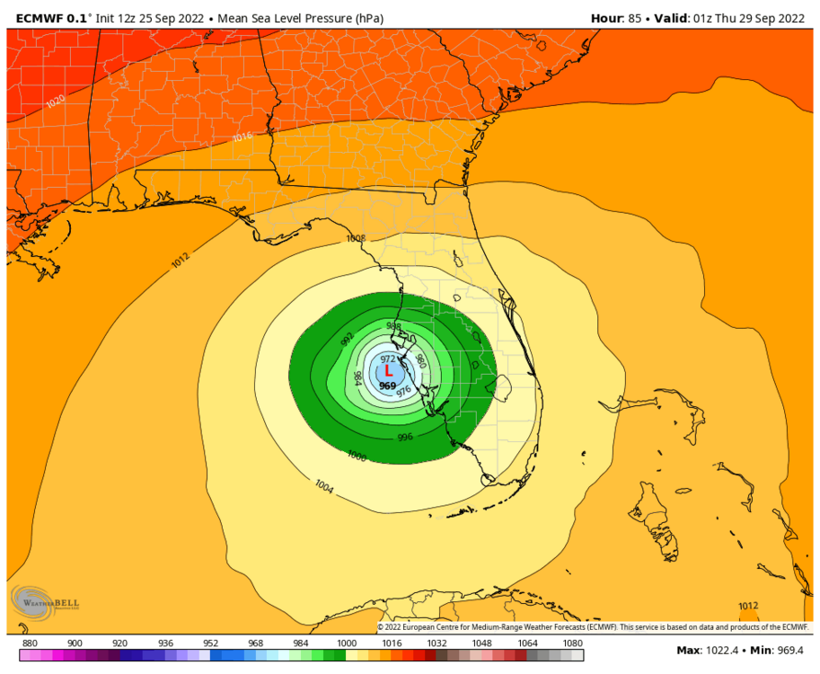
Yeah we are at risk of property loss except what fits in the cars.
Still high uncertainty with the track and intensity at this stage, could easily miss to the south.
-
1 hour ago, Dbullsfan22 said:
Maybe I’m just a super weenie nobody experienced wants to respond to but I was hoping for some responses from the Ian to Tampa crowd from my post in the banter thread, I posted it over there to not clutter over here, but it seems a lot of calling for a hurricane to a place that hasn’t been hit with one in 100 years. The odds just don’t seem likely
If you are referring to landfalling Majors, sure. But you know by now from following the thread that a TS or Cat 1 on certain trajectories can inflict extreme impact and damage around TB.
You should be just fine up there in Wesley Chapel, Florida.
-
While waiting for the 12z suite, here’s a good review of TB risk factors and scenarios
-
4 hours ago, StantonParkHoya said:
0z Euro straight into Tampa; crawling up Florida, only makes it to Gainesville in 24 hours. Looks like it’s heading to Atlanta.
overall pretty similar to 12z
4 hours ago, StantonParkHoya said:Honestly between 0z run yesterday of the Euro and 0z today, it’s maybe a 40 mile difference in track. Noise.
Split the difference with GFS is right where NHC has it. Big bend to central GA.
Yeah it’s noise but for an actual outcome a huge variable.
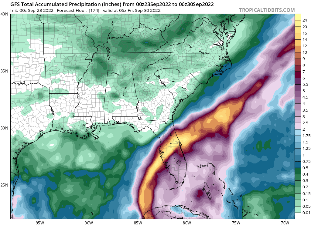
Surge much more amplified with 12z, while 0z lingers and dumps 20+ inches. Local flooding is common with summer downpours of 1-2 inches, can’t imagine what this would do.
-
Sandbags would be a nice aquarium feature for my yard with the Euro//UK solutions.
-
 3
3
-
-
Nightmare fuel, tho thankfully can’t treat with any confidence this far out.
-
Great to see west and weaker trending, relative to previous solutions.
-
 1
1
-
-
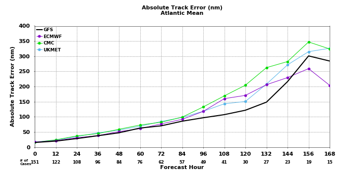
The NHC track forecast during this period has been
adjusted slightly south and west of the previous one, in line with
the track consensus aids. Beyond 72 h, there is still a large amount
of cross-track spread in the guidance as Ian emerges into the
eastern Gulf of Mexico and approaches Florida. Hopefully, data
collected from special radiosonde releases beginning later today and
a scheduled NOAA G-IV flight will help resolve the steering flow
around Ian and deep-layer trough that is forecast to be over the
eastern U.S. early next week. The guidance envelope has once again
shifted westward this cycle, and the official NHC track forecast has
been adjusted in this direction as well, though it still lies
slightly to the east of the TVCA and HCCA aids. Further adjustments
to the track forecast may be needed given the increased uncertainty
in the day 3-5 period.
-
7 minutes ago, Hotair said:
Cuba is not expecting it until Tuesday so we still have 4-5 days of tracking in front of us. Even a TS headed directly into Tampa Bay would cause considerable flooding damage to the area. Timing of LF and tide will be crucial here. I guess my concern here in Tampa is not so much the winds (building codes here are good through CAT 2 ) but the flooding potential especially if it stalls in the vicinity.
edit: just to vent, ridiculous that Hillsborough county in Tampa has no plans to provide sandbags to residents. Prior storms where we were well outside the cone, sand was made available. Pretty disappointing.
Always lots of focus on winds but yeah it’s mostly about the water here. I had a 4ft surge IMBY from eroding TS Eta and the center was 45 miles offshore. Of course with the heavy tree cover and vegetation here winds at TS or higher will leave a huge mess and power outages region-wide.
-
2
-
-
Region wide run on water and basics started yesterday. Many Target and Publix locations out of water already.
Most here take hurricane hype in stride given the rarity of actual impacts, but feels like more are in tune with scarcity after the 2020 pandemic driven issues with staples and necessities. You snooze you lose.
-
Late in the period, the
guidance indicates the storm will begin to recurve toward Florida.
As mentioned before, the track models are in general agreement with
this scenario, however there is a large amount of cross-track
spread at 72 hours and beyond.  In fact, the east-west spread in
the guidance at 96 hours is about 180 n mi, with the CTCI and ECMWF
along the eastern side of the envelope, and the GFS, HWRF, and GFS
ensemble mean along the western side.  The overall guidance
envelope has shifted slightly westward this cycle, and the NHC
track has been nudged in that direction and lies just east of the
various consensus aids.  Given the spread in the guidance, and
the still shifting dynamical models, additional adjustments to the
track forecast may be needed in subsequent advisories.  Users are
reminded that the long-term average NHC 4- and 5-day track errors
are around 150 and 200 n mi, respectively.
-
7 minutes ago, CamSE-Wx said:
I wouldn’t necessarily say further east, it’s actually more west but a much more drastic turn into north Tampa than elongated into the big bend area
Didn’t realize Tampa city limits are 100 miles north of town
-
11 minutes ago, MattPetrulli said:
New cone is slightly west

Along with an acknowledgement of increased track uncertainty late in the forecast period.
-
1
-
-
That GFS solution lays an atypically long duration S to SW fetch on TB and the coast. Lots of water to deal with even tho it stays offshore.
-
5 minutes ago, Prospero said:
I imagine toilet paper will disappear from the shelves by tomorrow night around here...
")
Always wise to get a jump on prep. I’ve seen enough from the 12z GFS to book a hotel in GA for next week as a contingency. Will most likely not be needed.
-
28 minutes ago, Windspeed said:


37 events over 175 years, 11 in the last 50 years.
Reckon we all have subjective views on the meaning of frequency and rarity.
-
1
-
-
3 minutes ago, GaWx said:
From the 11 AM EDT NHC discussion:
The latest NHC track forecast lies near the
center of the guidance envelope and closely follows the IVCN and
HCCA aids. This prediction is very similar to the previous one,
with only slight westward adjustments at days 3-5 to reflect the
latest model consensus trends.

The moderate to strong deep-layer northeasterly shear over the
cyclone is expected to persist through tonight, so only slight
strengthening is forecast through early Saturday. But once the shear
decreases to less than 10 kt this weekend, more significant
intensification is forecast as the cyclone moves over SSTs in excess
of 30 deg C. The latest NHC intensity forecast has been increased
from the previous one and explicitly calls for rapid intensification
as the cyclone crosses the northwestern Caribbean Sea. The system
is forecast to approach the Cayman Islands and Cuba as a
strengthening hurricane, with additional intensification likely once
it emerges over the warm waters of the southeastern Gulf of Mexico.
In fact, this forecast calls for the system to approach the Florida
peninsula as a major hurricane by day 5, which is supported by the
latest IVCN and HCCA aids.
Interesting for sure. We’ve beaten the Tampa thing to death, but it’s pretty rare for a major to landfall anywhere in Florida.
-
 1
1
-
-
1 hour ago, cptcatz said:
06z GFS with worst case scenario for Tampa. Good thing that won't happen since based on what I read here Tampa can't get hit?
It’s not the worst case scenario based on that track. Yes it would be a significant impact and highly disruptive. Trajectory needs to be mid to north Pinellas Country to maximize surge potential.
And correct, Tampa will not be hit directly by a major hurricane next week.
-
1
-
 1
1
-
4
-
-
-
Yeah it’s not going to take 30 hours to cross the peninsula.
-
56 minutes ago, Hoosier said:
I'm pretty sure at least 90% of the board wants a big hit on the Tampa area.
Unfortunately for those that marinate in such scenarios, the odds are near zero that it happens, ever.
Of course a Cat 1 on the Hurricane Phoenix trajectory would cause billions in damage here, so a big hit doesn’t need to be a high end storm.
-
1
-
-
Wanting a TC or post tropical system with massive accumulated energy to visit YBY is a bit like the dog catching the car, FAFO, etc.
-
2
-
1
-
-
-
17 minutes ago, Weather Mike said:
Possible but Euro still says no I am coming on shore just north of Tampa.
Will have to see what unfolds
More like 100 miles N around Cedar Key but it’s just one of many TBD op run track simulations
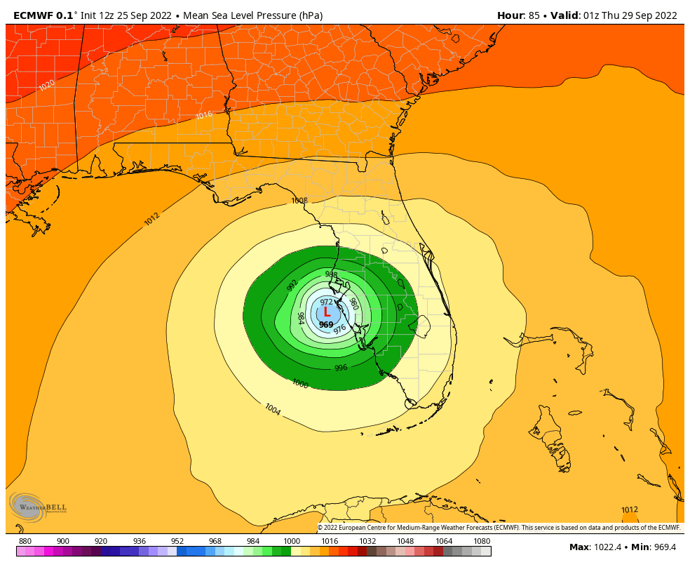
Hurricane Ian
in Tropical Headquarters
Posted
Feeling good that I booked our hotel options Friday.
Was just out to get groceries and gas, both a breeze because there’s a home football game in progress. Priorities and such.