

TPAwx
-
Posts
447 -
Joined
-
Last visited
Content Type
Profiles
Blogs
Forums
American Weather
Media Demo
Store
Gallery
Posts posted by TPAwx
-
-
10 minutes ago, Hoosier said:
Serious question since you're from there. Let's say the worst surge scenario is avoided in the event of a landfall farther south. What would 2 feet+ of rain do to the Tampa area?
it would be devastating. To preface, much of the area has minor but disruptive flooding with heavy summer t-storms. That much rain has no place to go. The city/metro has extremely dense vegetation and tree cover (one research outfit rated Tampa the #1 city in the world for tree cover). We obviously have tall palm trees but we have a lot of huge oaks. Massive amounts of trees and branches would come down on properties and streets, power outages would be extensive. All that falling and standing water would do a number on structures. With that stall easterly fetch would also push a ton of water around and carve up east facing shoreline. I'm not a hydrologist so I'm sure there's plenty of other impacts on infrastructure and public health.
Overall, a sub-optimal amount of rain and scenario.
-
 1
1
-
-
14 minutes ago, Amped said:
GFS keeps Tampa out of the storm surge but dumps 35" of rain.

Hard pass.
-
-
15 minutes ago, WxSynopsisDavid said:
The issue here is that coastline has tripled in population from 2004 and its way more populous now. There's no easy way about it, all these scenarios we are looking at are equally devastating. The original west track taking Ian north into the panhandle being ripped to shreds by shear/dry air before landfall might of been the best case scenario presented to us yet.
The scenarios are not equally devastating. TB/Hillsborough/Pinelllas County have a much higher degree of population/property/economic exposure and risk than Sarasota or Fort Myers. It’s easily accessible data and research.
-
GFS coming in tight to coast earlier, would drive higher surge across TB
-
2 minutes ago, Hotair said:
It’s bad enough that latest model runs took a further jog East. NHC incoming 5 pm will likely put TB dead center on their cone
Perhaps the UK hooked onto the late stage evolution from early stages and this goes inland south of TB.
-
7 minutes ago, eyewall said:
I think what is most notable about the GFS/Euro runs is the stall/crawl off Tampa before resuming the trip north.
Local surge watch was initialized at 5-8 and then updated to 7-10. With the GFS and Euro scenarios it would be higher in some locations.
-
Just now, LeesburgWx said:
GFS is
 worthy for Tampa
Reminds me of the NAM runs when I lived in NOVA that would spit out 50 inches of snow.
Thankfully this one won’t verify either

-
 2
2
-
 2
2
-
-
1 minute ago, beanskip said:
GFS very "pre Oz Euro"-looking.
Pretty much a nightmare run for Tampa Bay area.
It’s a crusher. Watching the loop, it literally crawls up to the bay and sits over us. Getting ready to eat a wrap and some onion rings from my freezer (use it or lose it), just lost my appetite.
-
2
-
-
GFS as depicted is really bad for TB
-
12z is coming in east of 6z
edit - material shift thru 63
-
ICON is a terrible solution for TB
-
1
-
-
Mandatory evac Zone A for Tampa peeps starting 2pm today.
-
Not a lot of analogues, but for reference Eta was in the low 990s at 50 miles off Clearwater Beach and produced a 4 ft surge in Old Port Tampa Bay. At peak Eta was 922/130 kts
-
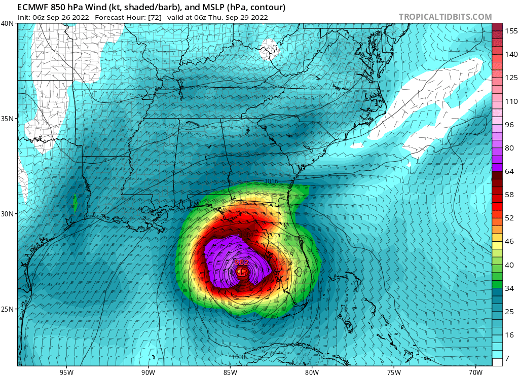
The full 6z Euro run has the crawl/stall WSW/W of Tampa Bay, and it’s pushing a ton of energy up the coast and in the bays. Not certain how this equates to total surge potential, but it remains an impactful solution and we still have margin of error with the track at this stage.
-
10 minutes ago, SnoSki14 said:
Thats a big shift west. Would spare Florida.
And then it slowly dies out on its way to the panhandle. Best case for Florida
Yeah the winds should be less of an issue whilst we launch the kayaks from our roof.
-
1
-
1
-
3
-
-
-
6z Euro appears to shift west
-
Opening bid is 5-8 for surge. Had 4 here with a weakening TS Eta 50 miles offshore, so….
STORM SURGE WATCH
NWS TAMPA BAY RUSKIN FL
512 AM EDT MON SEP 26 2022

FLZ151-261715-
/O.EXA.KTBW.SS.A.1009.000000T0000Z-000000T0000Z/
512 AM EDT MON SEP 26 2022
Coastal Hillsborough-

...HURRICANE WATCH IN EFFECT...
...STORM SURGE WATCH IN EFFECT...

A Hurricane Watch means hurricane-force winds are possible somewhere
within this area within the next 48 hours

A Storm Surge Watch means life-threatening inundation, from rising
water moving inland from the coastline, is possible somewhere within
this area within the next 48 hours

* LOCATIONS AFFECTED
- Tampa
- Apollo Beach
- Westchase

* WIND
- LATEST LOCAL FORECAST: Equivalent Tropical Storm force wind
- Peak Wind Forecast: 45-55 mph with gusts to 75 mph
- Window for Tropical Storm force winds: Wednesday morning
until Friday morning

- THREAT TO LIFE AND PROPERTY THAT INCLUDES TYPICAL FORECAST
UNCERTAINTY IN TRACK, SIZE AND INTENSITY: Potential for wind
greater than 110 mph
- The wind threat has remained nearly steady from the
previous assessment.
- PLAN: Plan for extreme wind of equivalent CAT 3 hurricane
force or higher.
- PREPARE: Efforts to protect life and property should now be
underway. Prepare for catastrophic wind damage.
- ACT: Act now to complete preparations before the wind
becomes hazardous.

- POTENTIAL IMPACTS: Devastating to Catastrophic
- Structural damage to sturdy buildings, some with complete
roof and wall failures. Complete destruction of mobile
homes. Damage greatly accentuated by large airborne
projectiles. Locations may be uninhabitable for weeks or
months.
- Numerous large trees snapped or uprooted along with fences
and roadway signs blown over.
- Many roads impassable from large debris, and more within
urban or heavily wooded places. Many bridges, causeways,
and access routes impassable.
- Widespread power and communications outages.

* STORM SURGE
- LATEST LOCAL FORECAST: Life-threatening storm surge possible
- Peak Storm Surge Inundation: The potential for 5-8 feet
above ground somewhere within surge prone areas
- Window of concern: early Wednesday morning until Thursday
afternoon

- THREAT TO LIFE AND PROPERTY THAT INCLUDES TYPICAL FORECAST
UNCERTAINTY IN TRACK, SIZE AND INTENSITY: Potential for storm
surge flooding greater than 6 feet above ground
- The storm surge threat has increased from the previous
assessment.
- PLAN: Plan for life-threatening storm surge flooding of
greater than 6 feet above ground.
- PREPARE: Evacuation preparations should be underway.
Assemble disaster supplies and know your evacuation route.
- ACT: Leave if evacuation orders are given for your area.
Failure to heed evacuation orders may result in the loss of
your life.

- POTENTIAL IMPACTS: Extensive
- Large areas of deep inundation with storm surge flooding
accentuated by battering waves. Structural damage to
buildings, with several washing away. Damage compounded by
floating debris. Locations may be uninhabitable for an
extended period.
- Large sections of near-shore escape routes and secondary
roads washed out or severely flooded. Flood control systems
and barriers may become stressed.
- Severe beach erosion with significant dune loss.
- Major damage to marinas, docks, boardwalks, and piers. Many
small craft broken away from moorings, especially in
unprotected anchorages with some lifted onshore and
stranded.
-
50 minutes ago, Prospero said:
Not looking good for Tampa Bay. Our home is five blocks from Boca Ciega Bay at about 15ft elevation. We are not considered in a flood zone, but a 15 foot storm surge is not impossible.
47 minutes ago, Weather Mike said:Yea woke up to a hurricane watch and I’m sure evacuations will be next for some of us. 06Z ICON still has it coming into the greater Tampa area.
18 minutes ago, Hotair said:Yep. My worst nightmare is unfolding. Had neighbor helping us with some sandbags. Will be leaving after rush hour to son’s house in Lakeland Everything wife and I could move is off the floor just in case we get lucky last minute and flooding is not what is expected. Frankly can’t see how we don’t get 2 to 4+ feet or more into the house as we have 10 ft elevation from SL -older house. Newer houses are all elevated in my area and have living areas about 10 or 12 feet above ground
once I saw Jim Cantore land in Clearwater yesterday I knew the jig was up.
Good luck fellas and be safe. On Bayshore a few feet above sea level fronting Hillsborough Bay, nowhere to hide here.
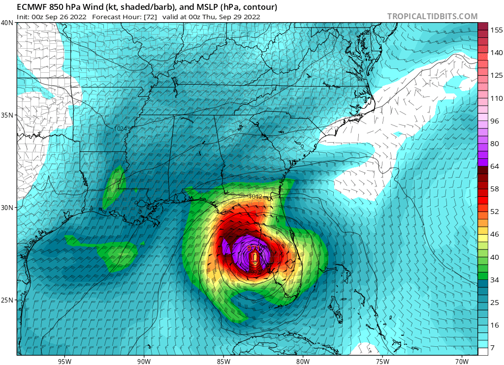
Will take the 0z UK. 0z Euro is sickening. 06z ICON actually landfalls slightly south, it would not be fun but the track avoids the worst for many.
-
So far it’s been “we need to get ready but it’s probably not going to be a direct or bad hit,” now it’s sinking in that it actually could be significant or worse.
And in Evac Zone A here it’s literally a “sinking” feeling
-
Tropical Storm Ian Discussion Number  12
NWS National Hurricane Center Miami FL       AL092022
1100 PM EDT Sun Sep 25 2022

The storm has become better organized-looking on satellite imagery,
with strengthening central convection and developing banding
features.  Upper-level anticyclonic outflow also appears to be
increasing over the system.  Flight-level winds, Doppler radar
velocities, and dropsonde data from a NOAA Hurricane Hunter aircraft
indicate that Ian's intensity is now near 55 kt.

Ian has turned toward the northwest and the initial motion estimate
is now 315/11 kt.  During the next 48 hours, the tropical cyclone
is expected to turn toward the north as it moves along the western
side of a mid-level high pressure area.  Later in the forecast
period, a broad mid-tropospheric trough over the eastern United
States is likely to induce a slightly east of northward motion.
However, around 4 days, the steering currents are forecast to
weaken as the trough moves to the east of Ian's longitude.  Some
of the guidance model tracks such as that from the GFS have, again,
shifted to the east, mainly after 48 hours.  The official track
forecast has been shifted somewhat to the east of the previous one
and is mainly a blend of the latest ECMWF and GFS predictions.  It
should again be stressed that there is still significant
uncertainty in the track of Ian, especially in the 3-5 day time
frame.  Users should not focus on the details of the track forecast
at longer time ranges.

Observations from the aircraft indicate that the tropical cyclone
is developing an inner core, so significant intensification is
likely to occur during the next couple of days.  The SHIPS Rapid
Intensification Index indicate a fairly high chance for rapid
strengthening during the next 24 to 36 hours, and the official
forecast reflects this likelihood, calling for Ian to become a
major hurricane over the southeastern Gulf of Mexico
-
24 minutes ago, MattPetrulli said:
It was pretty shocking to experience as most here had their guard down after escaping the worst of Irma. Also a good reminder that a lower end TC with lots of stacked energy can be extremely impactful here.
-
1
-
-
1 minute ago, Hotair said:
2 and a half to be safe. Probably don’t want to evacuate under major lightning storms. At least hillsborough schools have been cancelled now in preparation of storm shelters.
Once this gets to a Major and if the track still is close to TB, 75N and I4 will be a parking lot by late afternoon Tuesday.
Hurricane Ian
in Tropical Headquarters
Posted
Euro has landfall near
SarasotaSiesta Key/Venice late Wednesday