

TPAwx
-
Posts
447 -
Joined
-
Last visited
Content Type
Profiles
Blogs
Forums
American Weather
Media Demo
Store
Gallery
Posts posted by TPAwx
-
-
GEFS taking this just south of TB on 18z run.
Power outages and downed trees/vegetation likely the primary impacts here. Debris cleanup is mostly but not completely done from Ian.
Suppose the solutions that take it offshore would bring fetch up the bays and could present some flooding issues for parts of the area.
-
GEFS has the system slightly southwest of the op run thus far.
-
-
2 hours ago, turtlehurricane said:
The weather here has shifted drastically throughout the past 24 hours. Heavy rain showers coming off the ocean are becoming increasingly frequent, plus it is quite breezy.
This whole week is basically gonna be a hurricane situation, and the weather is already setting the mood.
Im quite excited to see how this pans out on satellite, it seems to be a hybrid super-storm situation.
Please maintain vigilance as the outer bands approach.
-
 1
1
-
-
Gonna need to turn the TB force field back on, had put it on sleep for the season.
-
1
-
-
No threat to the US as this eventually goes into Central America, if it develops.
-
 1
1
-
-
Dry and sunny conditions here in the aftermath of Ian.
Avg high around 85 for the next week with low humidity.
-
WRT to the next significant TC threat to Tampa Bay metro, sure there is a "cry wolf" variable but most people are able to understand imminent threats to life and property and will act accordingly, especially those most exposed or vulnerable.
There is always a slice of the populace, in TB and everywhere, that is skeptical or jaded towards threats from natural forces and will consider it a badge of pride to resist calls to evacuate or even prepare. And there may be more people not in direct peril that reconsider leaving the next time.
But there won't be a massive contingent of people refusing to evacuate the next time TB is in the cone a few days out from a significant TC.
-
1
-
-
Watching idiots on the seawall in St Augustine on TWC as waves and spray crash over them. JFC.
-
2
-
-
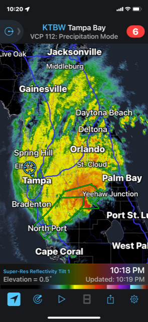
On the "fringe" of Ian has meant TS+ winds since afternoon and sideways rain for 4 hours and much more to come. No power at home in Tampa, so going to hold off on returning.
-
1.8 million in Florida have power out
-
 1
1
-
 1
1
-
-
1 hour ago, jbenedet said:
Really curious to know what’s going on in Tampa Bay Area right now. Have to imagine some severe coastal flooding all along the e south sections of the bay with the persistent northerly fetch.
1 hour ago, jbenedet said:I believe the biggest story will be rainfall. But the Tampa Bay Area is going to be right on the cut off for the heaviest. South/east sections get hit hard, north/west not bad at all.
Primary impacts will likely be downed trees and power outages. 50K offline so far in city of Tampa, more across Hillsborough.
37 minutes ago, Hotair said:I left my home in South Tampa and evacuated to Lakeland. The cam videos of my home do not show more than gusty wind and light rain all afternoon. no flooding.
Good decision to get out. Our webcams went off line and power is out in our South Tampa home.
-
1
-
-
Good local option for those interested
-
1
-
1
-
-
13 minutes ago, f2tornado said:
Potential record negative surge in the Tampa area. That's not good for what's on the other side.
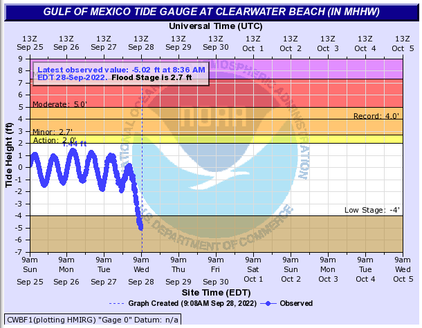
Better to utilize Old Port Tampa Bay gauge for "Tampa area"
https://water.weather.gov/ahps2/hydrograph.php?wfo=tbw&gage=optf1
-
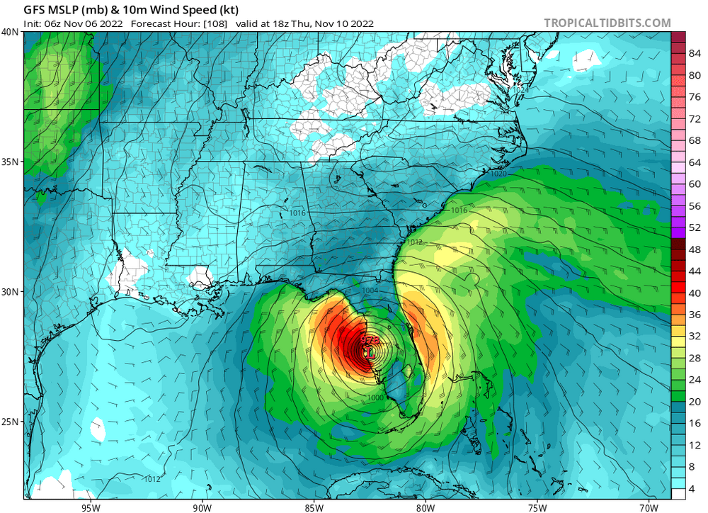
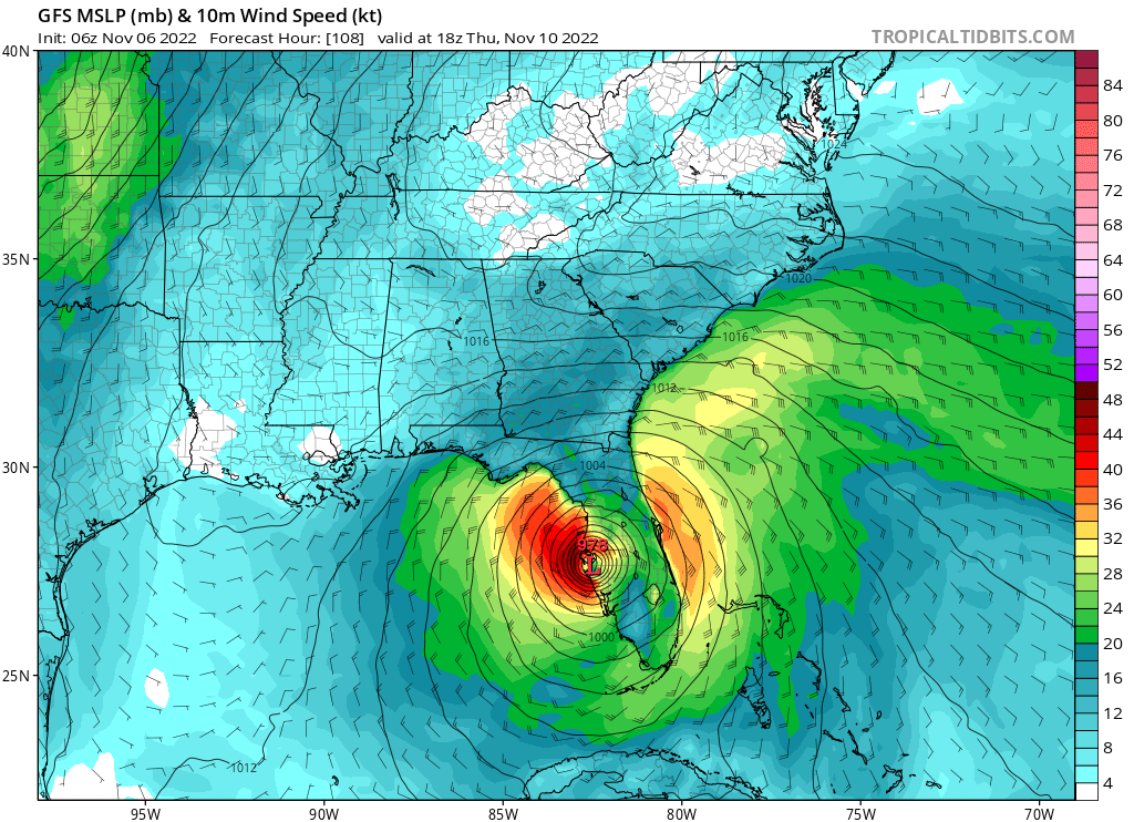
6z GFS has landfall between Englewood and Venice around 5PM.
Surprised to see the slight north jog overnight, impressive intensification to Cat 5.
Got the family 20 miles north of Tampa yesterday. Light to mod rain here and breeze is picking up.
.PNG.1a24cc2ae9eb2879f07323b9bafbd3cf.PNG)
-
GFS has landfall slightly north of Englewood Wednesday evening
-
18z GFS just a tick east at 15
-
3 minutes ago, DeltaT13 said:
Why does this worry people? Aren't we all here because we love big storms? There wouldn't be 165 members on this thread if we wanted storms to weaken. If people want to live in dangerous places that's there prerogative, I'm not going to stop being a weather enthusiast because people choose to live in high risk areas..
* their
-
Hillsborough County moved to mandatory evac for zone B, another 100k people. Lots will stay but the roads are gonna be dicey.
-
6z Euro has landfall right at Sarasota around 11pm Wednesday. That's a jump north from 0z
-
4 minutes ago, SnowGoose69 said:
Someone from Tampa would know this but wouldn't a landfall just south be a problem for places like eastern coastal St Pete and Pinellas point be vulnerable as a E-NE fetch of 50 plus knots pushes water across the bay...obviously you would not be piling water in advance from the Gulf but I imagine a nasty 3-4 foot surge could still happen
Yes indeed. You've got that sustained fetch for 24+ hours, layered with 20+ inches of rain that has nowhere to go. The main rivers are dumping all that into the bays. I'm on an east facing shoreline of Hillsborough Bay so I'm going to have an n=1 scenario play out.
-
Assuming track is south of TB headlines for this area will likely be extensive rain driven flooding and downed trees into structures. Some of the QPF outputs on the overnight model runs are ridiculous. Looks like 20+ is possible if the track and slowdown verifies.
-
Just now, shaggy said:
Would be better for Tampa with that south landfall for storm surge but still a brutal hit.
Yeah for sure, plenty of wind and 15+ inches of rain on this run.
-
Edit, Euro landfall between Siesta Key and Venice verbatim Wed 5pm
Hurricane Nicole
in Tropical Headquarters
Posted
992mb @ 7am EST
Good to see the updated track staying well north of Ft Myers area and TB