

TPAwx
-
Posts
446 -
Joined
-
Last visited
Content Type
Profiles
Blogs
Forums
American Weather
Media Demo
Store
Gallery
Posts posted by TPAwx
-
-
Appears y’all have moved on to crabbing season.
Last measurable snow here 47 years ago next Friday.
Glass half full and such.
-
 1
1
-
 3
3
-
-
-
Got a JD, passed the bar, and became partner since this system emerged off Africa.
-
 2
2
-
4
-
-
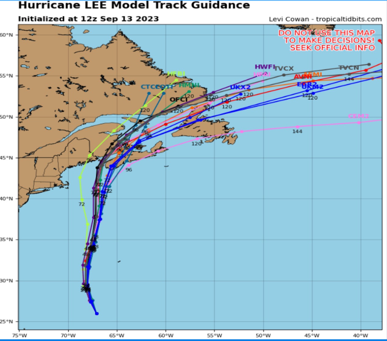
~175 mile average track error at 120h
-
Fantastic synoptic set-up to keep this monster away from a direct US impact.
Love it!!
-
1
-
 3
3
-
-
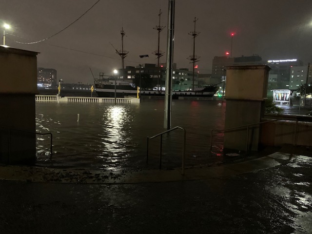
Lots of beautiful spots up the Nature Coast in serious trouble today.
-
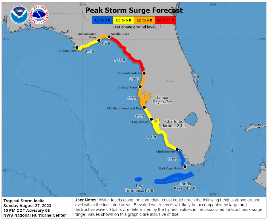
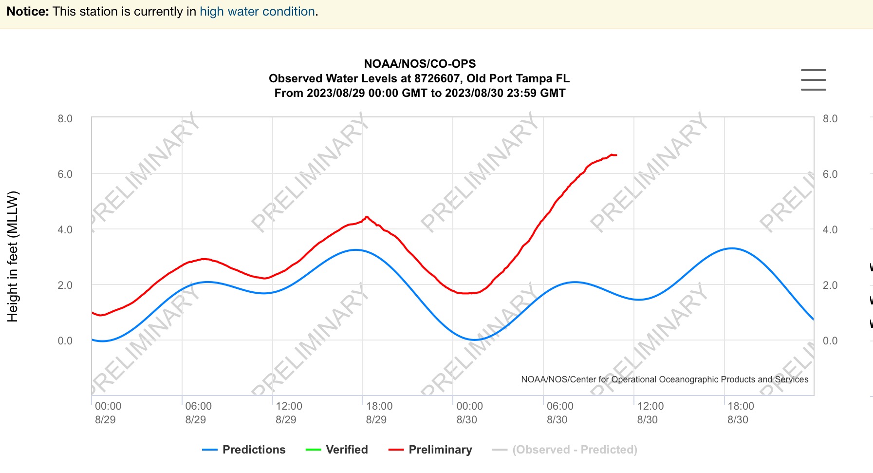
So the 4-7 for TB includes +1-2 from king tide
-
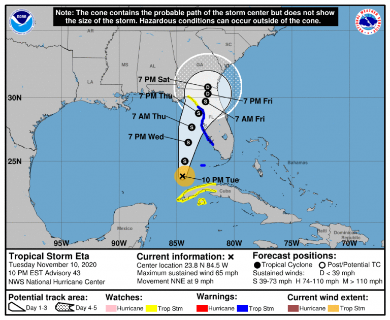
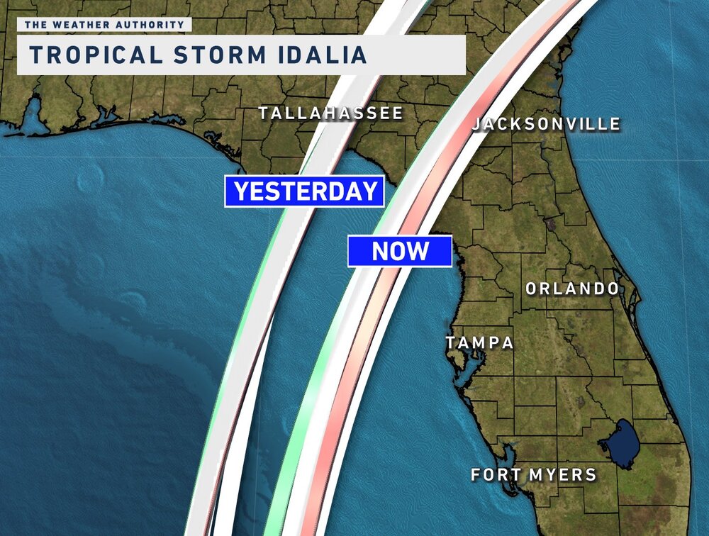
GFS has landfall near Dog Island Wednesday morning
-
10 minutes ago, KPITSnow said:
I just reread it. You’re right. I thought he meant it would be on the lower range of 4-7 feet
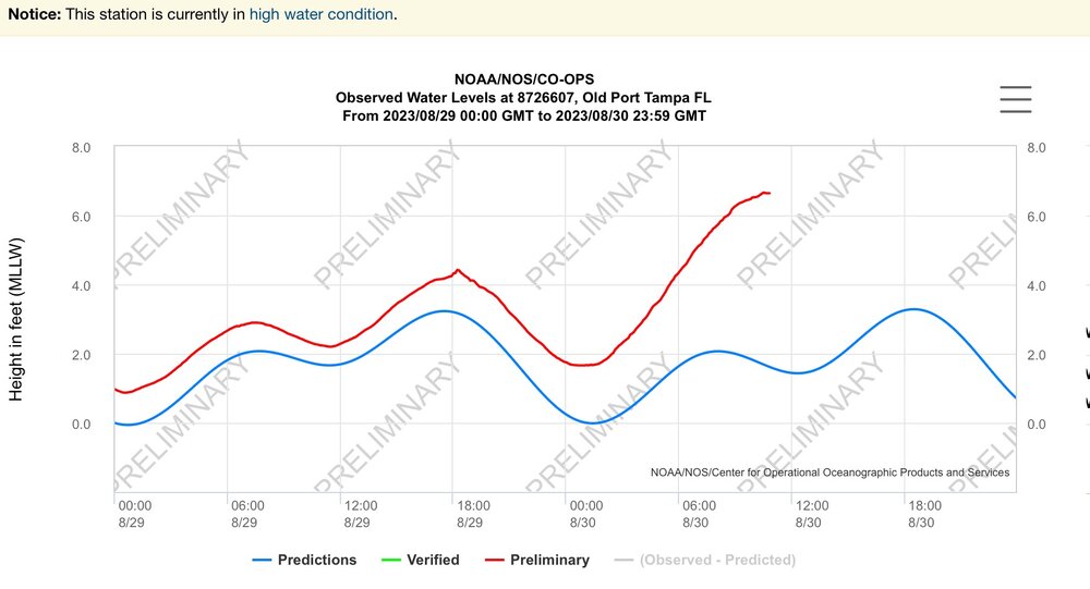
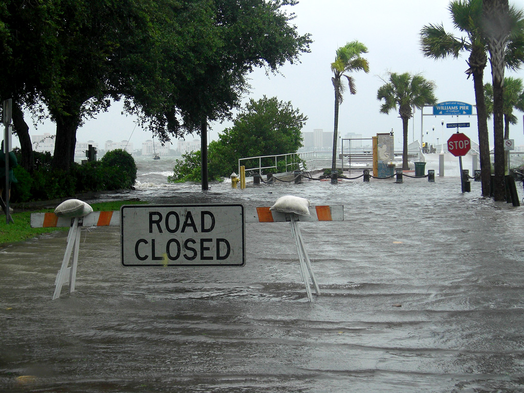
TS Eta gave us 4ft, the steps go down to a sidewalk and four traffic lanes and another sidewalk before the white barrier.
Idalia will be on top of an enhanced full moon high tide at a likely Cat 3 intensity. The 4-7 surge forecast could end up a bit higher.
-
1
-
-
18 minutes ago, Kevin Reilly said:
I think a lot of people are focusing on where landfall of Idalia will take place. Here is the bottom line If Idalia is say 60 miles west of the West Coast of Florida moving North or NNE or NE the entire coast will experience significant storm surge and anywhere just E or SE of where the Center comes ashore will be experience very severe to life threatening if a CAT 3 or 4 storm surge problems.
Had 4ft IMFY from TS Eta, on a not dissimilar track maybe a degree to the right of Idi’s current track. Of course Eta had a lot of energy built up. The 4-7 forecast for TB may end up on the lower range of possibilities.
-
3 minutes ago, Jersey Andrew said:
After the debacle in Fort Myers last year surrounding late ordered evacuations, Tampa metro has to be very concerned about storm track and surge threat. Weren’t Zone A and B evacuated last year before Ian took a more southerly track? Tough decisions ahead.
Yes Ian evacs were issued for most TB coastal counties on 9/26.
Really surprised Pinellas County hasn’t pulled the trigger yet, lots of folks at high risk even with current track. MacDill AFB just went mandatory so would expect Hills and Pinellas to follow soon for Zone A.
-
Euro remains to be seen, even with some westward movement on other guidance no reason for local TB region media mets and municipal officials to let up on messaging and urgency, esp for Zone A and B residents,
-
As 12z suite comes in, thinking about the ~50 n mi average track error at 48h
-
Up from last advisory
-
8 minutes ago, Prospero said:
This was a 3ft storm surge in Gulfport, FL during TS Debbie:

TS Eta's endgame track across Cedar Key in Nov 2020 gave us 4 ft along Bayshore.
-
1
-
-
21 minutes ago, Hotair said:
I’m very concerned over a potential Tampa LF. This storm is not on many folks radar and given it’s already late Sunday and folks go to school and work tomorrow means there’s less free time for any proper preparation
Ready to roll out of Zone A but yeah this is going to surprise a lot of folks.
We’ll see if the Tampa Bay No Majors in 102 years streak holds.
-
2
-
-
Interesting set up for TB region.
Most likely a miss but if steering supports East and it picks up more heat could be problematic.
-
Hefty band passing thru. Max gust so far 53 mph
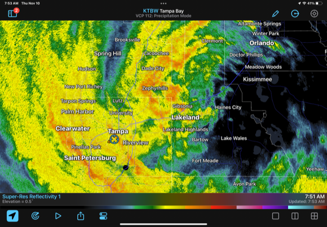
-
976mb reading on current pass
-
That’s a 5 mb drop. What the reasonable lid on deepening prior to FL landfall?
-
5 minutes ago, Hoosier said:
The past is not predictive, but I recall him doing quite well with projecting Ian's intensity.
There's an overall hyperbolic flair with him, but there's probably some potential upside on intensity compared to the official forecast.
He’s also the resident SME on outer band forecasting and dynamics.
-
5 minutes ago, TheGhostOfJohnBolaris said:
Gives Tampa the northern part of the storm..
That track is just far enough offshore to throw some fetch up the bays. Could be some flooding on top of the full moon tides that catch people off guard here.
-
18z GFS a bit SW of 12z as the system heads across the peninsula.
-
992mb @ 7am EST
Good to see the updated track staying well north of Ft Myers area and TB
-
3
-

March 2024 obs
in Southeastern States
Posted
Super intense line passed thru. Summer-like downpour.