

SENC
-
Posts
892 -
Joined
-
Last visited
Content Type
Profiles
Blogs
Forums
American Weather
Media Demo
Store
Gallery
Posts posted by SENC
-
-
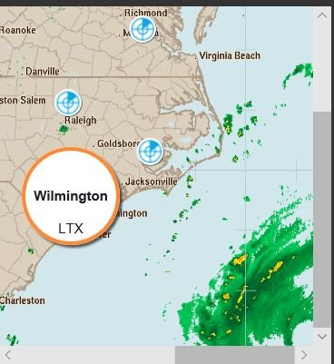
just starting to come with-in range.. of KLTX.. (KILM)?
-
Observation, just came off the Beach, (Carolina Beach),, High tide @ 11:45 pm,, Strong steady ESE~SE Winds STEADY @ 20mph..
Beach is already beginning to experience some , (Higher than Normal High tide, pushed by Winds) overwash
-
2 hours ago, Subtropics said:
@SENC Are you staying put in Wrightsville?
yes, but you mean Carolina Beach..
-
 1
1
-
-
9 minutes ago, forecasterjack said:
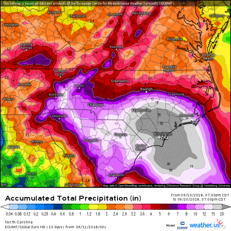
Another pretty crazy Euro run with the center meandering 5-10 miles offshore, while the NE quad scours the coast from Jacksonville to Wilmington and then beyond. Storm a little weaker on its SW drift compared to yesterday, probably reasonable given upwelling. Free/sharable ECMWF via https://weather.us/model-charts/euro/785-w-343-n/gusts-3h-mph/20180914-2100z.html
.thumb.png.d5bc0aedfa3bb0bce2daf7c0bb8f9da3.png)
That is one Crazy run Rakes NC all around.. but then the 46" Total QPF Map on the Earlier page matches up with it..
I'm just shaking my head..
-
50 minutes ago, mackerel_sky said:
High Risk excessive flash flood risk , issued by WPC! It’s only the 2nd time it’s ever issued one of those!! The 1st one was issued for Harvey!!
I just that "alert" too on My phone.. (I'm in Wilmington)
-
19 minutes ago, wncsnow said:
It wont intensify much if any due to upwelling and it is still the best run I have seen for NC coasts compared to EURO and other solutions.
11 inches of rain compared to 35 on the EURO.
Not really more like a "steady-State" IMOP.. Will be Fed from South to North By 86F Warm Gulf Stream Water(s)
WHILE it sliding south-South West,
In effect being "spoon fed", with Steady fresh Fuel... Say combined southward/SW motion and the 8-10 MPH Hot gulf stream waters, comin Northward.. Well Not much "upwelling" What-so-ever..
-
1
-
-
5 minutes ago, Orangeburgwx said:
So...
Floyd, Fran, Hugo, and Harvey all tied into one?
Yes I said this Late Last Week
All Wrapped in a nice Box with a red Bow...
The Box's name & contents were SHTF…
I'm still bullish on a Wilmington/Cape Fear Landfall as I was last week...
Though I wasn't expecting Flo to Stall and SET on top of Us though..
I wanted too "Share the Love" with Our inland Folks..
")
I had a few friends Leave Wilm today for Down south below Dirty Myrtle &Savannah GA , & Atlanta,Ga , I can only Imagine their Dismay to "bug out" only to be "followed", (if that comes to pass)..
With that said...
DT has some great commentary..
-
1
-
 1
1
-
-
49 minutes ago, ander420 said:
Look I am sensitive to all of this and not trying to be a dick about anything. I have just never seen such buy in and worry about the fall out. We cancelled 2 days of classes, basically a third and told parents and students to get the kids the heck out. Flying your kid to California or Boston or Philly or Florida or Oregon is a big expense for a lot of people and not just an inconvenience. The level of certainty in all this and how it was pitched (if it turns out wrong) is going to cause some significant problems that will eventually come back to bite people really hard. That is all I am saying. Personally, I have never seen folks in the Triangle take a storm more seriously in my years here. The threat was clear, it was communicated clearly, understood, and acted upon. The lack of doubts or possibilities along the way is going to leave a lot of folks angry and a lot of folks just not trusting this kind of stuff in the future. My two cents.
Ander420, Is in fact Quite Right If you seriously think about this. In todays Political Climate...
With ALL the Major media News organization(s) HYPING up this Storm, OMG End of the World is coming… After being called out & caught-up in many________, ending up with Egg in their faces for the Past Two years... Time after time..
Screaming, now, LISTEN to US! We are "thinking for you, AND then Tell you WHAT to think & Do" (It's for the Children you know)..
Gosh dern right the General Public at Large Will in fact Ignore ANY future Warnings.. Until it's to late...
Look at Memes All over the net concerning, & making fun of Jim Cantore, when He shows up before & during a Major Weather event..
Then there WILL be the reasoning that yes, in fact, MSN & Media are "earning" the Moniker of Fake News..
With that said...
Floyd dumped 19.50 +/- inches of Rain here in Wilm.. Ya'll remember what happened then..
I cannot Fathom 25~45 inches of rain with all the Development in the past 3~5 years in SENC..
Destruction would be on the Biblical Type scale.. Floyd AND Fran, times TWO...
-
 1
1
-
-
1 hour ago, NCSNOW said:
The timing and strength of the OV ridge is gonna decide who and where the hammer is gonna drop. Some folks gonna need that hammer to help construct an Ark.
Please FedEx Lumber to ME ASAP...
-
1
-
-
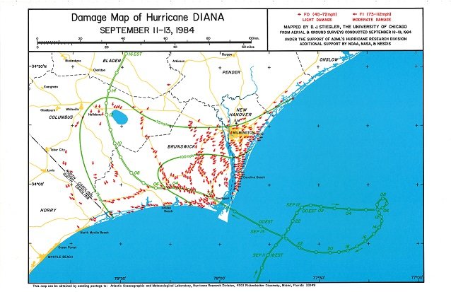
I know theres not a lot of "comparison" but...
-
next..
-
best I could finding" Diana" 1984
-
1
-
-
5 minutes ago, downeastnc said:
The GFS wants to be like the other models but it just cant figure it out.....it still ends up inland but only after doing the ridiculous dumb crap to get there.....I mean i guess that could happen but its really the only one showing that loop really at this point....even the ICON came west like all the other models.....
@DownEastnc you shooting doves yet? , get me a few crows while you're at it..
I think we'll all needa few
-
I said,, Cape fear Lock Since last week,, If not,, please bring My crow, I've got Wells BBQ
-
Never mind that 100 miles spread of cane force winds, It's going to be UGLY for ALL of us!
-
 1
1
-
-
10 minutes ago, downeastnc said:
GFS now south of ILM
how can I say.. Ohh oo.
Caving to the earlier Euro Tracks?
break out the beer?
Fire up the grille?
Break out the CROW?
-
7 minutes ago, downeastnc said:
Of course my first real hurricane Diana popped my tropical cherry.....I was 12 and she was the first real threat i remember.....
It appears our two eastern outliers the GFS and ICON have shifted west a bit.....ICON also no biting on the stall and west drift all the others have maybe that is a real trend \...its a ****ty one though lol
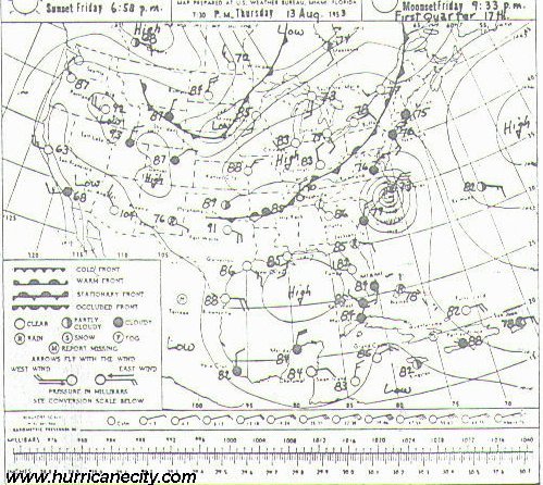
best I could find ATM..
https://journals.ametsoc.org/doi/10.1175/1520-0493(2001)129<1859%3ANSOTGO>2.0.CO%3B2
Looking for the atmospheric maps I'm coming up empty ATM..
Edit too add ALOT of Folks have even forgetting this one..
-
Just now, WidreMann said:
Which storm was that?
Dianne , 1984, If I recall
-
1 hour ago, downeastnc said:
Plenty of canes have stalled on or just off the coast.....usually though the models wouldn't be this clustered. The 00Z guidance is scary tight and the timing is getting well inside 72 hrs so just how much movement can there be in this range.....ultimately though if this thing stalls and loops offshore and misses altogether will anyone be that shocked......there just isn't much support for that at this time that all might change here in a few hrs with the 00Z's.
@Downeastnc remember this?
-
1
-
-
SST's from Frying Pan Tower are at.. 87F to 86 on the beach.. that is all..
Gasoline
-
With-in 24 hours, We'll know about, 24 hours into landfall I'll try to get 'safely" as close as I can, record video.. (with-in reason & police)..
I don't have a Wind aeromonitor , or barometric pressure gauge..
but I'll try to get good obs..
Are there "apps" for a smart phone,, android?
-
1
-
-
4 minutes ago, Wow said:
Not being political here.. just a friendly mockery of his tweeting skills.
Take care down there.
Thank you Sir, hope too post Obs & video..
-
Just now, stormtracker said:
Sure. Just be "carefull"
I am, "respectful" as I live on the coast, If I post Obs/video is it ok? Let's keep "politics" outta this seriously..
I really respect you despite being banned on the other side..
This is about WEATHER..
Peace, (lets make a truce)..
-
1
-
-
1 hour ago, WeatherNC said:
I’ll be honest, at this point I am more stressed and concerned than excited. Don’t get me wrong, I like a good sustained wind about as much as anyone, just as long as it’s not on my house. The real worry and I think at this point my house is ok, is the potential stall and biblical amounts of rain. That’s a worst case scenario for emergency management, two disasters to deal with as opposed to one. It would take 3-7 days for rain to empty into the sound, its not a fast process by any stretch and will greatly hamper reocervey efforts from the immediate storm.
Great too see some Long time posters show up..
.png.530e798b965dc79d515efdbb429f1baf.png)
Major Hurricane Florence: STORM MODE THREAD
in Tropical Headquarters
Posted
that little piece is almost here, been tracking it on radar..