

bubba hotep
-
Posts
2,665 -
Joined
-
Last visited
Content Type
Profiles
Blogs
Forums
American Weather
Media Demo
Store
Gallery
Posts posted by bubba hotep
-
-
6 minutes ago, 1900hurricane said:
The storms in North Texas still look like they're struggling with the capping for the moment.

Looks like 1st couple of attempts failed. You can see the orphaned anvils racing off to the SE on the newest sat images.
-
1 hour ago, Roy said:
It sure has. I think most are posting on the actual events pages now. But, I pretty much just lurk anyway. Hopefully tonight will be interesting. Just no huge hail IMBY please.
I tried to keep it going through the lame excuse for a winter that we had
 I've mostly been posting elsewhere lately or just randomly on Twitter.
With that said, the cap is still in place but things do look a bit concerning, esp for hail. I hate hail! The CAMs started giving hints yesterday that the main threat might shift south towards DFW today. Then the overnight run of the NCAR ensembles seemed to confirm that. Now to see what happens.
-
 1
1
-
-
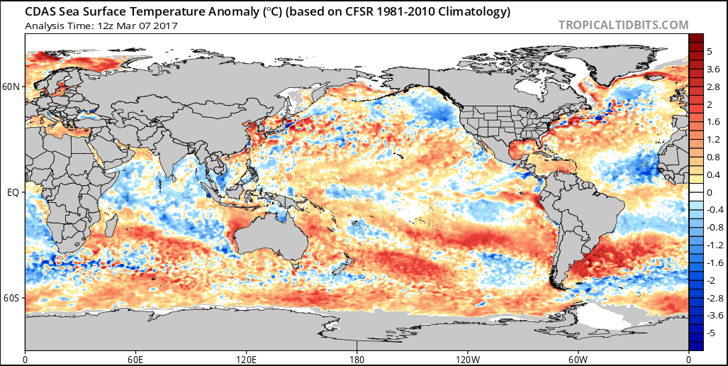
On 3/7/2017 at 4:52 PM, raindancewx said:
Fun pictures. Snow in Texas in March have been quite the shock for some people. We had 9.6" Feb 26-28 that winter, biggest non-Dec snowstorm in Albuquerque in 30 years.
One of the features of the 2014-15 Winter / Spring was the Atlantic actually got to the cold side of "average" in Feb-Apr. AMO ended up at 0.005 or something for Nov-Apr in 2014-15.
It's interesting to see it radically cooling off again in the East again.

That Atlantic sst configuration should result in another season of the MDR being a dead zone, if things don't flip back warm. I'll take +PDO/-AMO with ENSO transitioning to positive any summer!
-
22 hours ago, Quixotic1 said:
Well, that truthfully makes me feel better. Not enough to get a Davis weather station, but hopeful.
incidentally, you in the STAT department at TAMU? I'm working my masters.
What are you getting a masters in? I've been kicking around the thought of going back to finish my PhD.
-
5 hours ago, Chargers09 said:
South Central and SE Texas just got bumped from a marginal risk to an enhanced risk for tomorrow; all in one outlook.
Wonder if the front being further north than modeled today has influenced that.
These events have been popping up a lot so far in '17. Next Sunday to Tuesday could be another multi day event covering portions of this sub forum.
-
On 2/5/2017 at 3:51 PM, Quixotic1 said:
Yep! Actually a small system and then two storms where we got 6" in each of em. You were so upbeat and I had already buried the winter.
Ha! I do remember telling you in a site mail that we were going to score.
I'm trying to make the best of this trip to New Mexico. There were some snow showers today but I had to climb up above 8k ft to find them but the views are always worth it.

Even though the snow showers weren't much there was snow on the ground up higher
-
21 minutes ago, Quixotic1 said:
09-10 was awesome. I'd take it. Low solar too. I expect blocking to improve next year.
as for this year, killdeer are here in force. That is pretty much a tombstone for us.
I'm still holding out hope for the last week of Feb into 1st of March. Was it two years ago that our whole winter was basically two weeks at the end of Feb? One small system then a nice winter storm. I'll have to go back and look.
-
8 hours ago, raindancewx said:
I put out a Spring outlook if anyone is curious. In terms of oceanic conditions and the observed weather here in Nov-Jan, Spring 1997 did pretty well (borderline La Nina '96-97, wet in the SW, warm AMO, positive PDO, likely heading into an El Nino, nearing solar minimum, and so on). If you all like the cold weather in the Northwest...it's not going anywhere. Anyway, link is below.
Be curious to see if anyone has thoughts...it's going to live/die with the MJO.
Cool, I'll take a look tonight. I've kind of been kicking around '09 as an analog for the upcoming summer and then on into fall, esp. if the QBO switches. Winter '09/10 was Nino, weak +PDO, with a QBO switch during the summer. I'll have to do some more digging but Nino with -QBO has historically been a pretty good combo for Texas.
-
5 hours ago, Quixotic1 said:
Looks like a fast mover. What I wouldn't give for some blocking.
Maybe the PV will breakdown and help out? But my understanding, that probably won't contribute to blocking until later on in Feb or March? The MJO progression certainly supports a glancing blow of cold, if you buy that the atmospheric response to Nina is rapidly fading.
-
8 hours ago, Quixotic1 said:
I saw that. HM was tweeting about it. There was another met (I think Sam Lillo but get me to lying) that had done some work on it. Seems the theory was that the forcing from last year's El Niño was so strong it disrupted the QBO. One of the most regular oscillations in weather went AWOL.
I also remember seeing some stuff posted showing SSW were less likely during +QBO or they occurred much later in the winter.
-
Euro weeklies continue the theme of basically saying winter is over. At least if looks active moving towards March, maybe an early and active svr wx season.
-
On 1/26/2017 at 2:12 PM, bubba hotep said:
Yea, I basically never look at the QBO but it does seem to fit in with the overall pattern so far this winter. It looks like Nov & Dec were both the most positive readings for those months ever in the data that I can find.
The more I look at the QBO the more it appears to be playing a major role in the pattern. The wet California look is very +ENSO like but is also common during +PDO/+QBO winters. However, most +PDO/+QBO winters are also +ENSO, so the -ENSO is a bit of an oddity. I'm thinking that the +PDO/+QBO helps accelerate the atmospheric response to warming ENSO? The current run of +PNA looks a lot more like last winter than this winter and it looks to relax but then come back strong.

-
On 1/24/2017 at 10:39 PM, bubba hotep said:
Here is the D10 12z Euro EPS:
 th
th
That is basically a textbook example of the -5 day big -PNA loading pattern (basically the look 5 days before PNA would bottom out). This is Feb '89 3 days before a massive la nina cold snap in Texas (I don't remember why I didn't do -5 days but oh well, this looks a lot like the 12z Euro EPS at D12)

And then the Pacific jet retraction associated with that period:

Once again, this matches up pretty well with the 12z Euro EPS from today.
Here is the constructed MJO analog:
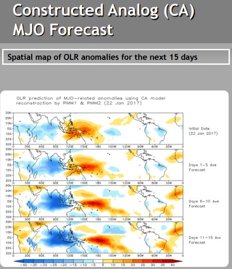
The thing to notice is the suppressed convection out near the Dateline in the D6-15 period and the Indian Ocean convection. How that convection progresses through the IO makes or breaks the upcoming period. MJO or faster progression and winter is over, slower progression and that teleconnects to big -EPO. Basically, everything is coming together for a big cold dump b/w Feb 7 - 10th +/-, if the MJO plays nice.
The MJO is quickly propagating and the torch is on for Texas. Maybe it will swing all the way round back to Phase 1 - 3 and we see some cooler weather by the end of Feb or March but climo starts working against us fast by then.
-
Snow reaching the ground in San Angelo
-
Man desperate for winter sees 18z GFS and then books a cabian at Beavers Bend State Park in Oklahoma lol
-
Wow, model trends are ugly as it gets right now. Winter seriously might be over with for N. Texas.
-
14 hours ago, Quixotic1 said:
Yeah. It's a bust so far. Maybe we can pull a 2008 type week out of there. That was another weak Nina after a Nino. It was really warm. Had one storm come through at night and gave us a few inches of paste after a 60 degree day and it was gone by noon as temps rebounded into the 50s. Had a bigger thundersnow event the same week where tarrant and Denton had up to 9" and Dallas got 1". Here in Collin we got about 3" but if it had been colder we could have been like Tarrant. Then it was gone. Severe season was good though.
honestly the QBO should have been taken in as a greater factor. It's strange behavior maybe should have indicated how things were more zonal rather than meridonal. Showed just how strong the Nino was last year.
I haven't heard of them but it looks reasonable. It has to be better than last year because we torched. Hope you make out well though!
Yea, I basically never look at the QBO but it does seem to fit in with the overall pattern so far this winter. It looks like Nov & Dec were both the most positive readings for those months ever in the data that I can find.
-
3 hours ago, Quixotic1 said:
Reports of IP in N.Texas.
It was warm and sunny in DC today... what a wasted winter. I was really pulling for a big EC winter storm this week but instead it was cold rain and now beautiful weather. What a waste
-
Here is the D10 12z Euro EPS:
th
That is basically a textbook example of the -5 day big -PNA loading pattern (basically the look 5 days before PNA would bottom out). This is Feb '89 3 days before a massive la nina cold snap in Texas (I don't remember why I didn't do -5 days but oh well, this looks a lot like the 12z Euro EPS at D12)
And then the Pacific jet retraction associated with that period:
Once again, this matches up pretty well with the 12z Euro EPS from today.
Here is the constructed MJO analog:
The thing to notice is the suppressed convection out near the Dateline in the D6-15 period and the Indian Ocean convection. How that convection progresses through the IO makes or breaks the upcoming period. MJO or faster progression and winter is over, slower progression and that teleconnects to big -EPO. Basically, everything is coming together for a big cold dump b/w Feb 7 - 10th +/-, if the MJO plays nice.
-
3 minutes ago, raindancewx said:
My original idea for February, the first image was for it to be cold in the middle of the country. Still like that, but it's probably centered further north than I had it.
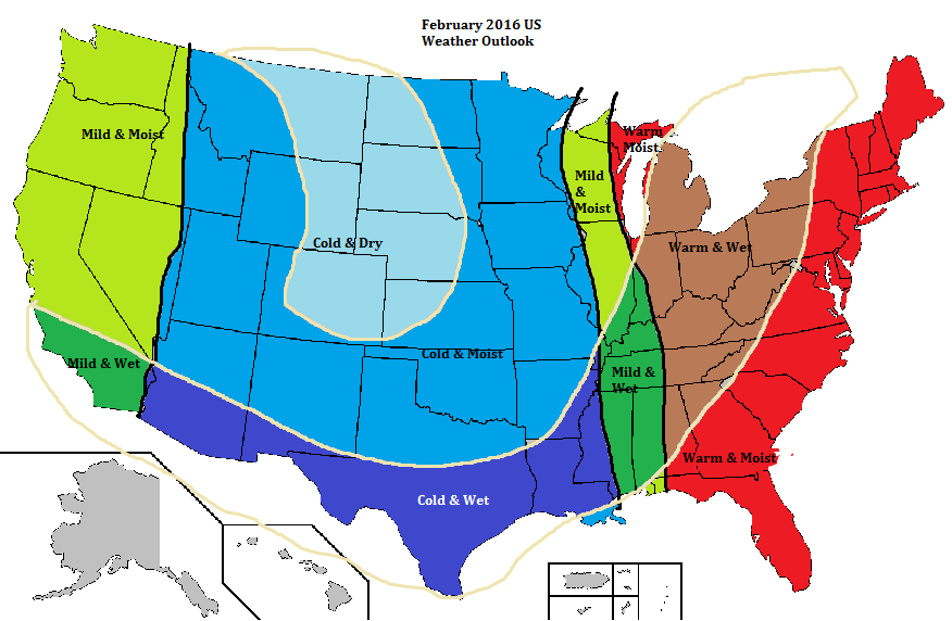
That is probably a safe bet with SSW being the wild card. I think we see another big -EPO nina like cold shot around Feb 7 - 10th but how fast we warm up depends on the AO/NAO. If we can get some blocking, then maybe the first map holds but, if not, then the 2nd map is a good bet.
-
It doesn't get much uglier in the long range than the 12z GEFS...

-
1 hour ago, raindancewx said:
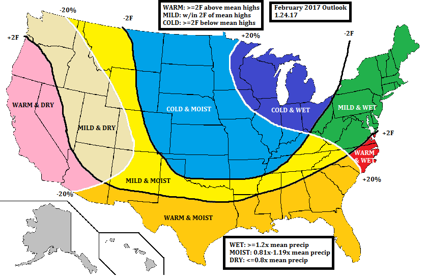
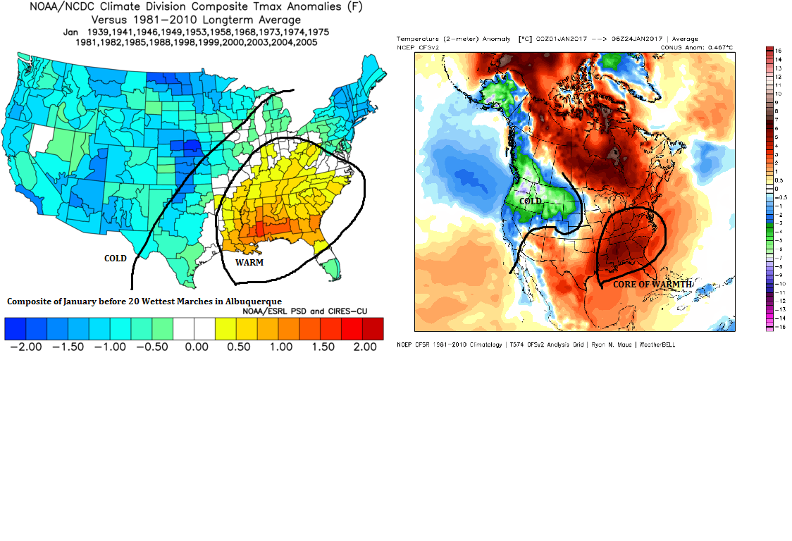
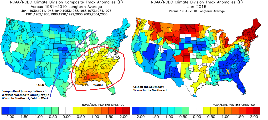
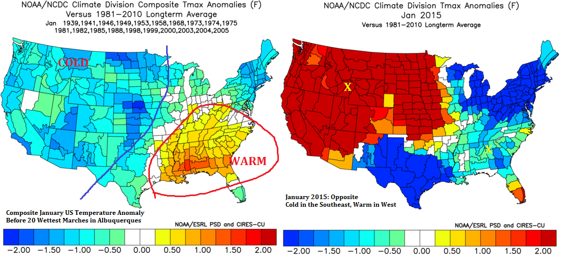
I think this might be the first wet March in New Mexico/Arizona since 2007. Look at January temperature anomalies ahead of the 20 wettest Marches v. the last two years (El Ninos) and then this year. The composite "super warm SE, coolish West" signal is readily apparent in 2017, and that is the signal for a wet March here.


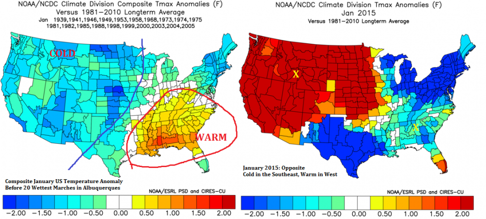
That is interesting, I would guess that a lot rides on how fast the low frequency nina background state breaks down heading into the spring.
-
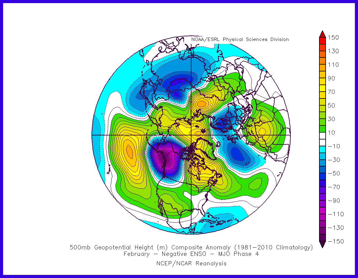
Not surprising, given the MJO looks phase 4ish for early Feb:
-
The models are building cold in Western Canada in the longer range but they are all showing a stubborn SW ridge and that look makes it hard to get cold down to Texas. If that ridge is persistent, then we might see all the cold slide off to the NE. Our chances of any type of winter weather look bleak through the 1st week of February.
Texas/New Mexico/Louisiana/Mexico Obs And Discussion Thread Part 8
in Central/Western States
Posted
What an epic bust for DFW... Looks like no rain at all.