Chicago Storm
-
Posts
19,232 -
Joined
-
Last visited
Content Type
Profiles
Blogs
Forums
American Weather
Media Demo
Store
Gallery
Everything posted by Chicago Storm
-

November 2024 General Discussion
Chicago Storm replied to SchaumburgStormer's topic in Lakes/Ohio Valley
ORD has had three SNINCR OBS this morning. Two OBS with +SN as well. -
November 2024 General Discussion
Chicago Storm replied to SchaumburgStormer's topic in Lakes/Ohio Valley
Lake and Cook Counties will definitely be the winner with this, where that better banding has been in place for longer. May be able to add DuPage County into that as well. A bit further west, a little over 1” here so far in North Aurora (I moved from Naperville in September). -
November 2024 General Discussion
Chicago Storm replied to SchaumburgStormer's topic in Lakes/Ohio Valley
Chicago/ORD on the board today with the first T of snow on the new season. -
November 2024 General Discussion
Chicago Storm replied to SchaumburgStormer's topic in Lakes/Ohio Valley
and for that matter, you don’t live in any of those listed cities. -
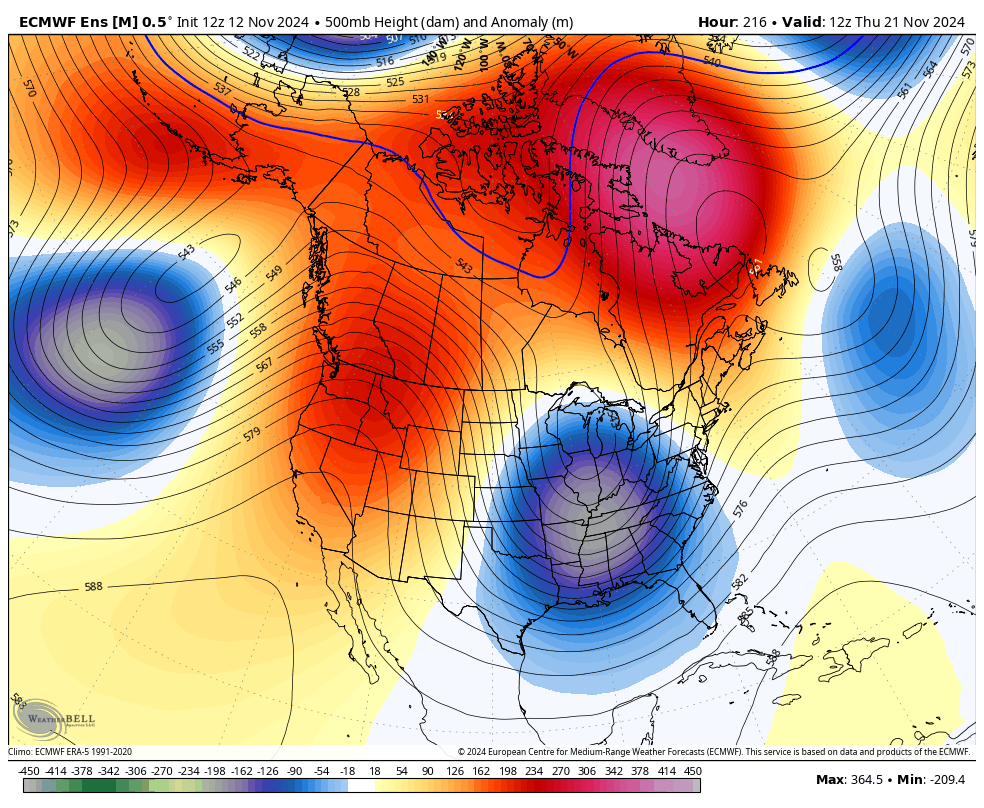
That's a significant and block-y pattern change showing up for next week.
-
Fall/Winter '24 Banter and Complaints Go Here
Chicago Storm replied to IWXwx's topic in Lakes/Ohio Valley
Slightly. The Euro is also now available out to 360hrs on WxBell. -
November 2024 General Discussion
Chicago Storm replied to SchaumburgStormer's topic in Lakes/Ohio Valley
ORD had a low temp of 63° on Nov 4th, which broke the record high min temp for the date of 61° (2022). The low temp of 63° on Nov 4th also tied the all-time November record high min temp of 63°, set 11/9/2020, 11/7/1975, and 11/6/1924. -
Chicago Weather Records Tracking
Chicago Storm replied to Chicago Storm's topic in Lakes/Ohio Valley
Chicago/O'Hare had a low temperature of 63° on November 4th, which broke the record high minimum temperature for the date of 61° (2022). The low temperature of 63° on November 4th also tied the all-time November record high minimum temperature of 63°, set 11/9/2020, 11/7/1975, and 11/6/1924. -
Chicago Weather Records Tracking
Chicago Storm replied to Chicago Storm's topic in Lakes/Ohio Valley
i have no clue why i had september in there. oops. -
Chicago Weather Records Tracking
Chicago Storm replied to Chicago Storm's topic in Lakes/Ohio Valley
9/24/1931. Currently we are ranked 27th latest. -
November 2024 General Discussion
Chicago Storm replied to SchaumburgStormer's topic in Lakes/Ohio Valley
No chance. Two day observed and radar rainfall totals are 1-1.50" across the entirety of DeKalb Co, with ~1" the past 24 hours alone (As of this morning). -
October 2024 finished tied as the 9th warmest October on record for Chicago. Record Warmest October's 1. 64.3° - 1963 2. 62.2° - 1971 3. 62.1° - 1947 4. 61.9° - 1920 5. 61.4° - 1900 6. 60.8° - 1956 6. 60.8° - 1879 8. 59.8° - 1924 9. 59.7° - 2024 9. 59.7° - 2021 9. 59.7° - 1953
-
Chicago Weather Records Tracking
Chicago Storm replied to Chicago Storm's topic in Lakes/Ohio Valley
October 2024 finished tied as the 9th warmest October on record for Chicago. Record Warmest October's 1. 64.3° - 1963 2. 62.2° - 1971 3. 62.1° - 1947 4. 61.9° - 1920 5. 61.4° - 1900 6. 60.8° - 1956 6. 60.8° - 1879 8. 59.8° - 1924 9. 59.7° - 2024 9. 59.7° - 2021 9. 59.7° - 1953 -
ORD had a low temperature of 68° on Wednesday, which broke the record high min temp for the date of 62° (1974).
-
Chicago Weather Records Tracking
Chicago Storm replied to Chicago Storm's topic in Lakes/Ohio Valley
Chicago/O'Hare had a low temperature of 68° on October 30th, which broke the record high minimum temperature for the date of 62° (1974). -
ORD had a low temperature of 67° yesterday, which broke the record high min temp for the date of 65° (1946).
-
Chicago Weather Records Tracking
Chicago Storm replied to Chicago Storm's topic in Lakes/Ohio Valley
Chicago/O'Hare had a low temperature of 67° on October 29th, which broke the record high minimum temperature for the date of 65° (1946). -
Fall/Winter '24 Banter and Complaints Go Here
Chicago Storm replied to IWXwx's topic in Lakes/Ohio Valley
idiotic. they should focus more on consistently having good forecasts first. -
ORD had a high temperature of 82° today, which broke the record high max temp for the date of 78° (1999/1901).
-
Chicago Weather Records Tracking
Chicago Storm replied to Chicago Storm's topic in Lakes/Ohio Valley
Chicago/O'Hare had a high temperature of 82° on October 29th, which broke the record high maximum temperature for the date of 78° (1999/1901). -
Today is what all deep fall days should be like.
-
Right at peak fall foliage color across the area right now. If not for the drought, it's quite possible that peak conditions may have not been until early November. The consistently mild temps did a great job at offsetting drought effects, allowing the peak as late as we're seeing now.
-
If it's coded as hail, it will not count towards being the 2nd earliest snowfall on record.
-
Fall/Winter '24 Banter and Complaints Go Here
Chicago Storm replied to IWXwx's topic in Lakes/Ohio Valley
For those that are bored and want to watch random hurricane clips, video is up... -
CPC outlooks are useless. They're always "forecasting" what a certain ENSO pattern should look like. Long range forecasts months in advance are useless in general.