Chicago Storm
-
Posts
19,232 -
Joined
-
Last visited
Content Type
Profiles
Blogs
Forums
American Weather
Media Demo
Store
Gallery
Everything posted by Chicago Storm
-

1/24-1/25 Major Winter Storm - S. IL, IN, and OH
Chicago Storm replied to A-L-E-K's topic in Lakes/Ohio Valley
hoosier was kicked from the board, think it was last winter (?). -
1/30-1/31 Lake Effect Snow Threat - SE WI, NE IL, and NW IN
Chicago Storm replied to A-L-E-K's topic in Lakes/Ohio Valley
congrats southern cook and nw indiana? -
I’m talking more-so through current time, that it has not been an East Coast pattern thus far. I probably should have been more clear with that. With the pattern expected to relax a bit coming up to end the month and begin February, during that timeframe the East Coast definitely holds the best chance for a bigger event. The pattern looks to shift and re-load deeper into February, bringing more widespread chances of something better. Until then, we’ll probably be in clipper mode, unless a surprise hybrid pops up.
-
ORD has picked up 8.7" of snow over the past two weeks, thanks to several clippers + LE. It may not seem like a lot, but we are now sitting at average snowfall for the month of January. Other areas in NE IL and the metro have received even more than that (Up by the border & along the lake). Did the East Coast rack up a big snowfall this weekend? Sure, but so did a majority of the subforum. A foot of snow fell 4 hours from here. If it were an East Coast pattern, none of the above would be reality.
-
1/24-1/25 Major Winter Storm - S. IL, IN, and OH
Chicago Storm replied to A-L-E-K's topic in Lakes/Ohio Valley
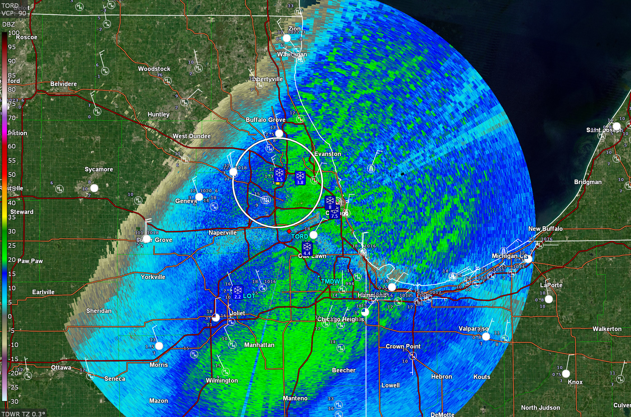
Lake effect saved the day... Also, an honorable mention of 5.9" at MDW CO-OP. Final snowfall totals 4.4" - ORD T - RFD …2025/26 Season Snowfall... 28.6" - ORD 23.9" - RFD -
1/24-1/25 Major Winter Storm - S. IL, IN, and OH
Chicago Storm replied to A-L-E-K's topic in Lakes/Ohio Valley
ORD snowfall total was 3.5" at noon, but more was added. -
1/24-1/25 Major Winter Storm - S. IL, IN, and OH
Chicago Storm replied to A-L-E-K's topic in Lakes/Ohio Valley
the game likely would have been moved, unfortunately. -
1/24-1/25 Major Winter Storm - S. IL, IN, and OH
Chicago Storm replied to A-L-E-K's topic in Lakes/Ohio Valley
pats/seahawks. -
1/24-1/25 Major Winter Storm - S. IL, IN, and OH
Chicago Storm replied to A-L-E-K's topic in Lakes/Ohio Valley
Some synoptic enhancement right now, but that aside, that's a quality shredded multi-band look that we just don't see on this side of the lake very often.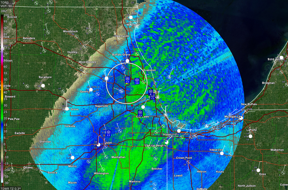
-
1/24-1/25 Major Winter Storm - S. IL, IN, and OH
Chicago Storm replied to A-L-E-K's topic in Lakes/Ohio Valley
METAR KORD 251651Z 34012KT 3/4SM R10L/5000VP6000FT -SN VV015 M11/M13 A3010 RMK AO2 SLP208 SNINCR 1/3 P0000 T11061133 $ -
1/24-1/25 Major Winter Storm - S. IL, IN, and OH
Chicago Storm replied to A-L-E-K's topic in Lakes/Ohio Valley
This could end up being the most widespread-significant nearly pure multi-band LES events that I can remember on this side of the lake...
- 935 replies
-
- 13
-

-

-
1/24-1/25 Major Winter Storm - S. IL, IN, and OH
Chicago Storm replied to A-L-E-K's topic in Lakes/Ohio Valley
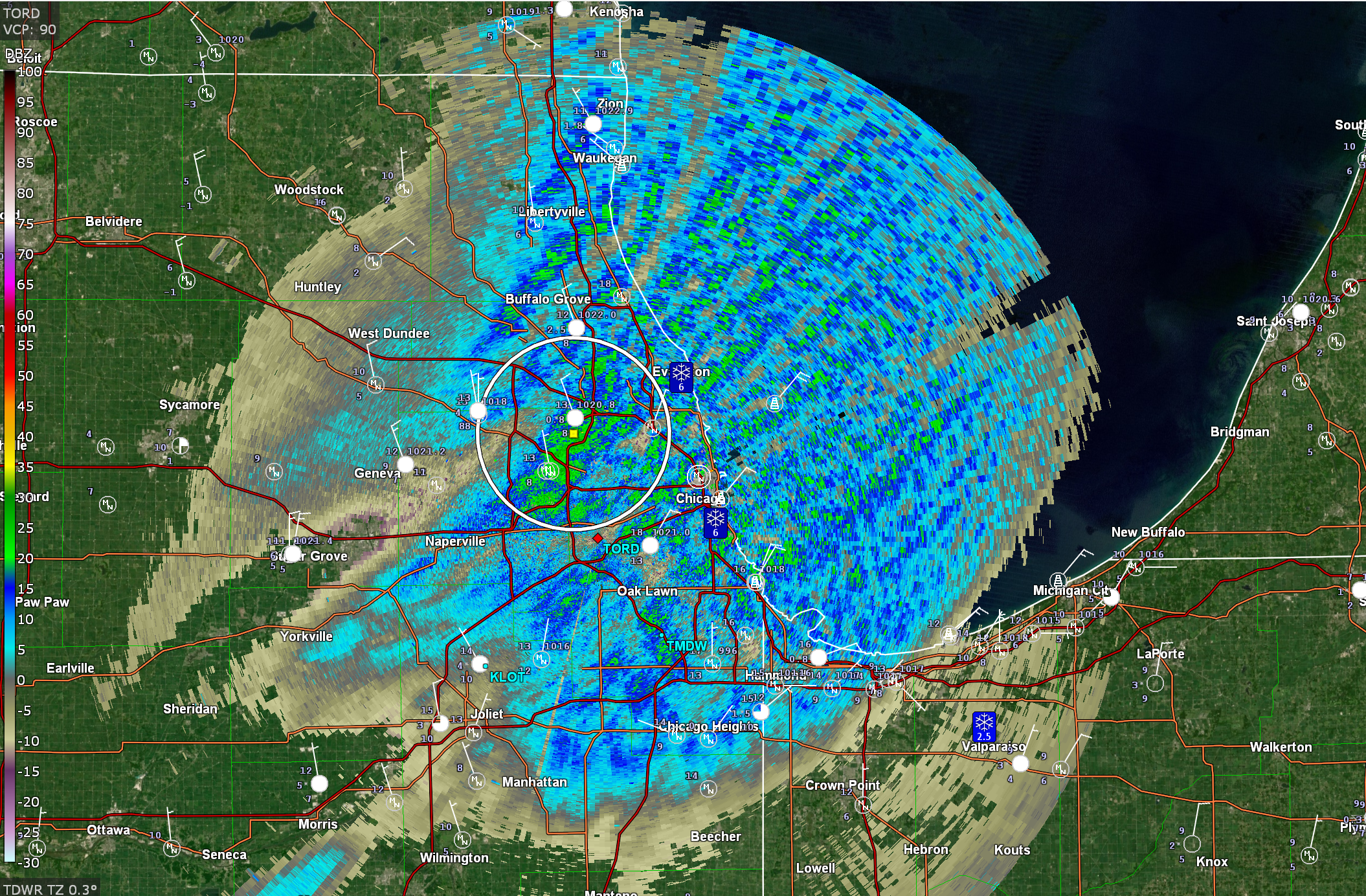
The multiple meso-lows of earlier tonight have sort of morphed into a main one now, which is attempting to back towards MKE.
-
1/24-1/25 Major Winter Storm - S. IL, IN, and OH
Chicago Storm replied to A-L-E-K's topic in Lakes/Ohio Valley
Looks like mixing has gotten further north than anticipated down-state, just south of Carbondale-Harrisburg. -
Low temp of -10 at ORD this morning.
-
1/24-1/25 Major Winter Storm - S. IL, IN, and OH
Chicago Storm replied to A-L-E-K's topic in Lakes/Ohio Valley
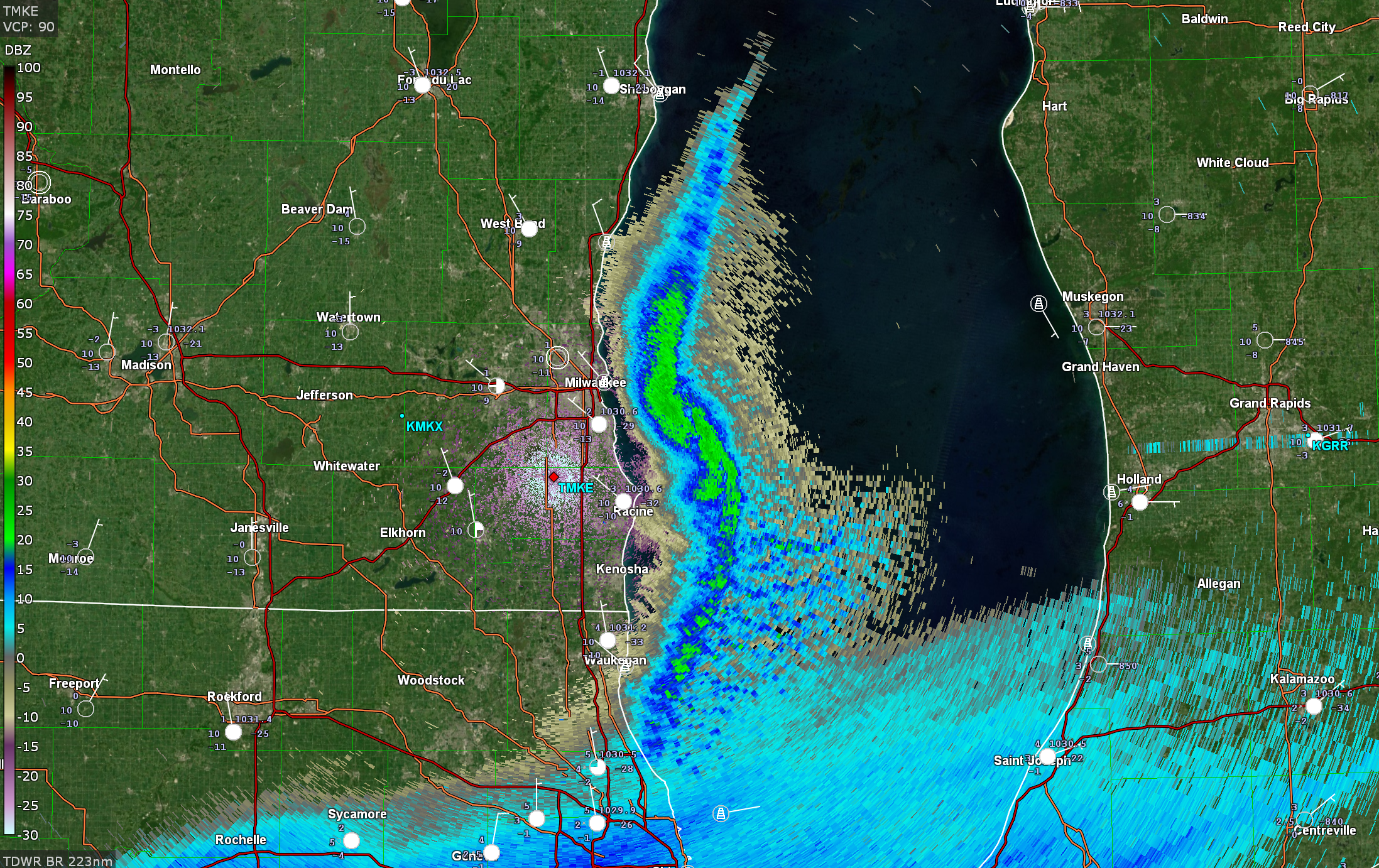
Lake enhancement is doing work downtown. Looks like about SN 1/2SM on the EarthCam. -
1/24-1/25 Major Winter Storm - S. IL, IN, and OH
Chicago Storm replied to A-L-E-K's topic in Lakes/Ohio Valley
I do think that it'll move further onshore. The main question more-so is how far onshore it'll move and how long it will take up residence in a particular area. -
1/24-1/25 Major Winter Storm - S. IL, IN, and OH
Chicago Storm replied to A-L-E-K's topic in Lakes/Ohio Valley
Multiple meso-lows out over the over the lake. That southern one is potent.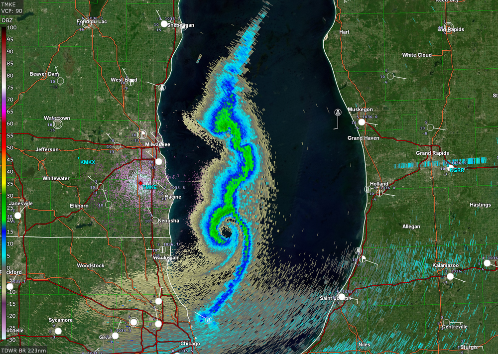
- 935 replies
-
- 12
-

-
-
1/24-1/25 Major Winter Storm - S. IL, IN, and OH
Chicago Storm replied to A-L-E-K's topic in Lakes/Ohio Valley
Lake enhancement is coming onshore in the immediate downtown area currently. -
1/24-1/25 Major Winter Storm - S. IL, IN, and OH
Chicago Storm replied to A-L-E-K's topic in Lakes/Ohio Valley
he is not. -
1/24-1/25 Major Winter Storm - S. IL, IN, and OH
Chicago Storm replied to A-L-E-K's topic in Lakes/Ohio Valley
the hrrr also says no snow till midnight or so. in reality, it's already about to start snowing, albeit light. it's struggling with the saturation progress. -
1/24-1/25 Major Winter Storm - S. IL, IN, and OH
Chicago Storm replied to A-L-E-K's topic in Lakes/Ohio Valley
i'd prefer 97/75 and an evening bow echo, thanks. -
Low temp of -11 at ORD this morning. The daytime high temp was limited to -4, but the actual high for the day was 5 at midnight. The peak wind chill was -36.
-
1/24-1/25 Major Winter Storm - S. IL, IN, and OH
Chicago Storm replied to A-L-E-K's topic in Lakes/Ohio Valley
The whole thing is a shit show, quite honestly. I get what they are doing and why they are doing it. However, your new model system (RRFS/REFS) really should be much better than your old model system (NAM/SREF), which hasn't had an upgrade in many years. -
1/24-1/25 Major Winter Storm - S. IL, IN, and OH
Chicago Storm replied to A-L-E-K's topic in Lakes/Ohio Valley
solid assessment, as always. are you still at cle? -
1/24-1/25 Major Winter Storm - S. IL, IN, and OH
Chicago Storm replied to A-L-E-K's topic in Lakes/Ohio Valley
the run-to-run changes 'under the hood' aloft are fun to watch on any given model. see the nam 12z vs 18z, just as a recent example. really struggling to resolve things.