-
Posts
42,229 -
Joined
Content Type
Profiles
Blogs
Forums
American Weather
Media Demo
Store
Gallery
Posts posted by LibertyBell
-
-
The 1944 hurricane was extremely underrated, it was a Great Hurricane that came after a Historic Summer.
Great Atlantic Hurricane (Sept. 1944)
There's a good reason why New Jersey State Climatologist David Robinson calls the Great Atlantic Hurricane "the worst hurricane ever to hit New Jersey in the 20th century." The damage unleashed by this storm was devastating along the entire coastline, with hundreds of homes on Long Beach Island washed out to sea and huge piers in Atlantic City split up into pieces.
A resident who witnessed the 1944 destruction in Atlantic City told The Star-Ledger decades later: "It picked up the boardwalk like toothpicks and threw it.” (Photos by New Jersey State Police | NJ State Library)
Len Melisurgo | NJ Advance Media for NJ.com
Great Atlantic Hurricane (Sept. 1944)
This hurricane was so powerful that it swept large boats and barges onto land in Atlantic Highlands, grounded a large passenger boat in Keyport, crushed roads and sections of the boardwalk in Long Branch and destroyed the boardwalk and sea wall in Margate. (Photos by New Jersey State Police and U.S. Navy | NJ State Library)
More rare photos of the Great Atlantic Hurricane of 1944
Len Melisurgo | NJ Advance Media for NJ.com
Great Atlantic Hurricane (Sept. 1944)
The 1944 storm was ferocious, blasting the Jersey Shore with winds as strong as 96 mph and waves reported to be as high as 25 to 30 feet. Hundreds of homes were destroyed on Long Beach Island and hundreds more on the Barnegat Peninsula.
On LBI, the hurricane’s storm surge pushed vacation cottages off their foundations and deposited them blocks away. In Manasquan, the storm left 6-foot sand dunes along First Avenue, looking like snowdrifts. In Cape May, the grand piano in Convention Hall was reportedly washed out to sea. (YouTube video by wetwatervideo)
Len Melisurgo | NJ Advance Media for NJ.com
Great Atlantic Hurricane (Sept. 1944)
This video recounts the widespread destruction in Atlantic City. One witness says parts of the city were under 5 feet of water and he watched the ocean surge rip apart large sections of the Atlantic City boardwalk. (YouTube video by pcctv1)
-
3 minutes ago, LibertyBell said:
Wow the 1821 storm makes the much publicized 1938 storm sound like a small gale.
Norfolk - Long Island Hurricane (Sept. 1821)
This massive storm, known as the Norfolk and Long Island Hurricane of 1821, churned its way up the Atlantic coast from Virginia and slammed into Cape May in southern New Jersey as a fierce Category 3 hurricane before speeding up along the Jersey coast and pounding New York City and Long Island. Damage was reported to be heavy in Cape May, where a 5-foot storm surge flooded the small resort city and sustained winds were believed to be as high as 110 mph. This map, produced by the Swiss Re global reinsurance company, shows the storm's likely path. (Swiss Re)
Len Melisurgo | NJ Advance Media for NJ.com
Norfolk - Long Island Hurricane (Sept. 1821)
This graphic shows the intense winds generated by the Norfolk and Long Island Hurricane of 1821, which flooded Cape May and pounded the Jersey Shore, New York City and Long Island. (Swiss Re)
1903 also had a very strong hurricane that took a path close to the city, what category was this storm?
Great Hurricane (Sept. 1903)
The Great Hurricane of 1903 made a direct hit on New Jersey, causing heavy flooding and structural damage up and down the Shore and as far inland as Trenton (pictured here in a major flood that followed the storm).
Among the damage reported by Shore News Today: “Hurricane-force winds downed telephone and telegraph wires across the coast, ripped the roofs off of 60 cottages and destroyed the railroad bridge to Brigantine. Most Jersey Shore fishing piers were severely damaged or destroyed.” (Photo credit: Trentoniana collection | Trenton Public Library)

Len Melisurgo | NJ Advance Media for NJ.com
Great Hurricane (Sept. 1903)
The Great Hurricane of 1903 made a direct hit on New Jersey, causing substantial damage to houses and barns, many of which had their roofs blown off, according to a report by NorthShoreWX.com. The storm’s ferocious winds reportedly uprooted scores of shade trees and fruit trees across the Garden State.
In Sea Bright, some houses were completely destroyed by this hurricane, the New York Daily News reported. Pictured is an old map showing the storm's path. (Photo credit: NOAA)
-
3 minutes ago, WestBabylonWeather said:
Just before 9
How bright was it? Like a regular star or brighter like a planet?
-
12 minutes ago, SACRUS said:
Wow the 1821 storm makes the much publicized 1938 storm sound like a small gale.
Norfolk - Long Island Hurricane (Sept. 1821)
This massive storm, known as the Norfolk and Long Island Hurricane of 1821, churned its way up the Atlantic coast from Virginia and slammed into Cape May in southern New Jersey as a fierce Category 3 hurricane before speeding up along the Jersey coast and pounding New York City and Long Island. Damage was reported to be heavy in Cape May, where a 5-foot storm surge flooded the small resort city and sustained winds were believed to be as high as 110 mph. This map, produced by the Swiss Re global reinsurance company, shows the storm's likely path. (Swiss Re)

Len Melisurgo | NJ Advance Media for NJ.com
Norfolk - Long Island Hurricane (Sept. 1821)
This graphic shows the intense winds generated by the Norfolk and Long Island Hurricane of 1821, which flooded Cape May and pounded the Jersey Shore, New York City and Long Island. (Swiss Re)

-
2 minutes ago, WestBabylonWeather said:
Saw a crazy shooting star on the way home on the southern state. Was green.
are you serious-- at what time? it has to be really bright to see one on a highway in all this light pollution!!
-
Just now, WestBabylonWeather said:
Atlantic beach was nice. We know someone that lives there now so we had parking and access. Did not like the drive from Babylon but it was great otherwise.
it's like a one hour drive or an hour and a half by LIRR (I used to work near the Babylon LIRR station.)
-
 1
1
-
-
46 minutes ago, WestBabylonWeather said:
Hey you were in my neck of the beach lol, how do you like the beaches here?
-
2 hours ago, donsutherland1 said:
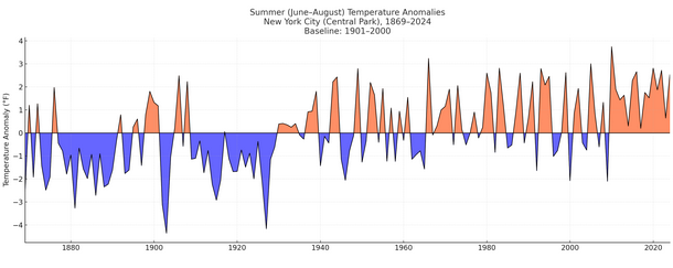
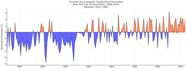
NOAA uses a 20th century (1901-2000) baseline for assessing anomalies for purposes of climate analysis. This is how NYC's summers look using the 20th century baseline:
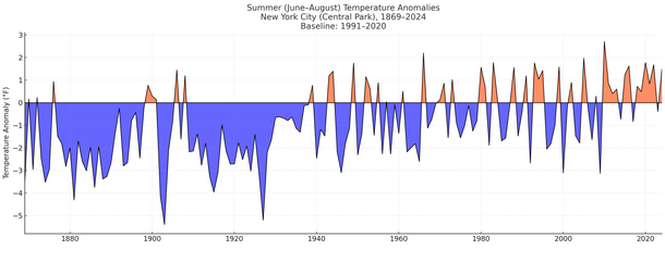
For purposes of "normals," the latest baseline period is 1991-2020. Here's how NYC's summers look using that baseline:
The last summer cooler than the NOAA's long-term 20th century baseline was summer 2009. The last summer cooler than the 1991-2020 baseline was summer 2023. Summer 2025 will wind up warmer than both baselines.
Using the 1991-2020 baseline the huge changed happened around 1940, but I like the other two baselines more, which shows that our summers changed a lot starting in 1930.
-
18 minutes ago, donsutherland1 said:
Don there are some extremely cold summers prior to 1930, something we have not seen since.
There's a huge change pre 1930 to post 1930, what flipped in 1930 to do this?
-
7 hours ago, WE GOT HIM said:
I'm gonna do some painting upstate.
it's perfect weather for that and also to do some power washing!!!!
-
 1
1
-
-
7 hours ago, anthonymm said:
This. I think we're cooked until the western pac stops boiling. Has there been a single extreme -pdo type winter that ended up good for us??
Maybe 1966-67?
That was the last time I can think of there was a historic winter in the Pac NW and on the east coast in the same season.
It was the best winter of the 1960s (although 1960-61 also makes a very strong case.)
-
 1
1
-
-
8 hours ago, gallopinggertie said:
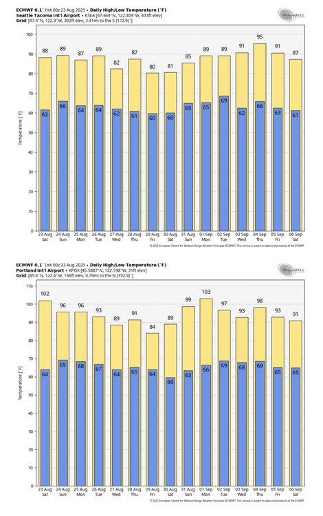
It’s looking like this might only be the beginning of this particular hot period - here’s the new ECMWF forecast for Seattle and Portland, showing a two-week stretch that would average 10-15 degrees above normal for the region. Pretty wild.
I’ve lived in western Washington and Oregon my whole life, and the summer climate has really changed over just the past couple decades. Like you posted about, heat waves used to last maybe two or three days - now they stretch on for a week, or longer. Here in Portland our climate averages have historically fallen in the Csb (warm-summer Mediterranean) range, but are on track to push into Csa territory (hot-summer Mediterranean) before too long, perhaps when the new 2000-2030-year averages become the new baseline. Seattle probably will follow a few decades later.
wow you're very lucky, our longest heatwaves were in the 1950s and the 1990s.
-
32 minutes ago, donsutherland1 said:
For those tracking the heat in the Pacific Northwest, Portland has now reached 100° or above for the second consecutive day. August 22-23, 2025 is the latest two-day or longer streak on record. The prior latest two-day streak of 100° or above occurred during August 19-20, 2016.
Don is that more rare or is the back to back 102 at JFK in late June more rare?
-
On 8/22/2025 at 7:39 PM, donsutherland1 said:
Yes, that's correct. So far, at least seven sites in Oregon or Washington have reached 100 or above. Daily records have fallen at locations including Corvallis, Portland, and Vancouver (WA). Portland finished with a high of 102.
It's interesting, while that happens the number of 100+ highs around here in August and September has dropped markedly since the 1950s.
-
5 hours ago, bluewave said:
That’s why so many people are moving out to the Desert Southwest. Many people are OK with the extreme summer heat and drought. Then they can take weekend ski trips during the winter to get their fill of snow and cold.
To be fair, thats a little too extreme lol.
2010 was my ideal winter/summer/winter I don't think it can get any better than that around here.
-
 1
1
-
-
1 hour ago, donsutherland1 said:
NOAA uses a 20th century (1901-2000) baseline for assessing anomalies for purposes of climate analysis. This is how NYC's summers look using the 20th century baseline:
For purposes of "normals," the latest baseline period is 1991-2020. Here's how NYC's summers look using that baseline:
The last summer cooler than the NOAA's long-term 20th century baseline was summer 2009. The last summer cooler than the 1991-2020 baseline was summer 2023. Summer 2025 will wind up warmer than both baselines.
How about if we use the 1951-1980 baseline we all want to use Don?
-
13 hours ago, bluewave said:
Really comfortable pattern here the rest of the month as the next heatwave will miss well to out north with record mid 90s staying up near the tundra. This should be one of the more extreme late season over the top warm ups we have seen. Unfortunately, it will promote more drought and wildfire activity up in Canada.
I hope that smoke stuff doesn't make it down here, I'm getting used to these deep blue skies
-
 2
2
-
-
24 minutes ago, steve392 said:
Continued on the say of my sister-in-law's wedding up here. Cool breeze made it a perfect day.
Yes really great late summer / early fall weather
-
10 hours ago, SACRUS said:
Records:
Highs:
EWR: 93 (1989)
NYC: 92 (1916)
LGA: 92 (1996)
JFK: 91 (1978)
Lows:
EWR: 55 (1982)
NYC: 51 (1923)
LGA: 56 (1952)
JFK: 57 (1994)
Historical:1683: A hurricane which made landfall in Virginia and moved from Virginia to Massachusetts. Extensive damage was done in Rhode Island, and the torrential rains from the hurricane caused the Connecticut River to rise 26 feet above its usual level causing a tremendous flood in the Connecticut Valley.(Ref. Hurricane of 1683)
1724 - An event is known as the "Great Gust of 1724" occurred on this day. Almost all tobacco and much of the corn crops were destroyed by this violent tropical storm, which struck the Chesapeake Bay. Intense floods of rain and a huge gust of wind were seen on the James River. Some homes were wrecked, and several vessels were driven ashore. The storm was likely followed by a second hurricane just five days later causing rain for many straight days that caused the Virginia floods of 1724.
1806: A hurricane of great size and destructive power raged along the Atlantic coast from the 21st to the 24th. As the slow moving storm gained forward speed, shipping suffered severely. The coastal ship "Rose in Bloom" capsized during the morning off Barnegat Inlet, NJ, with the loss of 21 of the 49 persons on board. This disaster received wide national publicity. Further north, Cape Cod, MA received 18 inches of rain, which ruined crops. The storm also caused major shipping losses. (Ref. Wilson Wx. History)
1851: The Great Middle Florida Hurricane of 1851 struck the area near Apalachicola and St. Marks. (Ref. AccWeather Weather History)1906 - Thunderstorms deluged Kansas City, MO, with six inches of rain during the early morning, including nearly three inches in thirty minutes. (The Kansas City Weather Almanac)
1921 - Denver, CO, was drenched with 2.20 inches of rain in one hour, a record for that location. (The Weather Channel)
1933: A hurricane made landfall near Nags Head, North Carolina and tracked up the Chesapeake Bay. The Chesapeake-Potomac hurricane moved over Norfolk, Virginia, and Washington, DC. A seven-foot tide flooded businesses in Norfolk, Virginia. Described in the American Meteorological Society's August 1933 weather review as "one of the most severe storms that have ever visited the Middle Atlantic Coast."
1933 - The Chesapeake-Potomac hurricane moved over Norfolk VA and Washington D.C. A tide seven feet above normal flooded businesses in Norfolk, and damage in Maryland was estimated at seventeen million dollars. (David Ludlum)
1939: A long dry spell began in central Illinois. This was the first of 37 consecutive days where no measurable rain fell at Springfield, a record dry spell for the city. (Ref. Wilson Wx. History)
1955: Hail in Houston County, with piles to a foot deep at Rushmore, SD. (Ref. AccWeather Weather History)
1963: Project Stormfury was armed and ready as Hurricane Beulah moved across the Atlantic Ocean north of Puerto Rico. An armada of planes carried out the seeding and monitored the results of the experiment. On the 23rd, Beulah did not really meet the criteria for seeding. On the following day, the storm met the criteria of having a well-formed eyewall and the seeding appeared to be successful as the eyewall disintegrated. No other hurricanes would be seeded until 1969 because of a lack of good targets. (Ref. Wilson Wx. History)
1966: A bolt of lightning struck and killed a surfer who had just come out of the water while surfing at Surf City, NJ. The surfer was standing at the ocean's edge when lightning struck. (Ref. Wilson Wx. History)1970 - Dry thunderstorms ignited more than one hundred fires in the Wenatchee and Okanogan National Forests of Washington State. Hot, dry, and windy weather spread the fires, a few of which burned out of control through the end of the month. More than 100,000 acres burned. (The Weather Channel)
1974: Brown's Summit, NC -- a 9-year-old girl was killed by lightning. Wawarsing, NY-- A 15-year-old girl was killed by lightning and five others were injured while camping during a thunderstorm. (Ref. Lightning-The Underrated Killer.pdf)
1987 - A cold front brought autumn-like weather to the Northern and Central Plains Region. Afternoon highs were in the 50s and 60s across parts of Colorado, Kansas and Nebraska that just two days earlier were in the 90s or above 100 degrees. Thunderstorms produced locally heavy rain in New Mexico, Texas, Oklahoma and Arkansas. (The National Weather Summary)
1988 - Thunderstorms produced hail an inch in diameter, wind gusts to 64 mph, and 2.62 inches of rain at Tucson AZ resulting in three million dollars damage. Cool weather prevailed in the northeastern U.S. Hartford CT reported a record low of 42 degrees. (The National Weather Summary) (Storm Data)
1989 - Thunderstorms produced heavy rain with flash flooding in West Virginia. Pickens, WV, reported 4.80 inches of rain in 24 hours. Evening thunderstorms in Mississippi deluged Alta Woods with 4.25 inches of rain in less than an hour. Thunderstorms also produced heavy rain in southeastern Kentucky, and flooding was reported along Big Creek and along Stinking Creek. The Stinking Creek volunteer fire department reported water levels 12 to 14 feet above bankfull. Fort Worth TX hit the 100 degree mark for the first time all year. Strong winds ushering cool air into northwest Utah gusted to 70 mph, raising clouds of dust in the salt flats. (The National Weather Summary) (Storm Data)
1992 - While South Florida residents were preparing for Hurricane Andrew, folks in western Montana were dealing with early season snowfall. Some snowfall amounts include 8.3� in Great Falls, 6.2 in Helena, and 5.1 in Cut Bank. This snowfall is the first significant snowfall on record in western Montana in August.
1998: Massive flooding caused by heavy rains from the remnants of dying Tropical Storm Charley struck the town of Del Rio, TX. 18 inches of rain fell from Sunday night through Monday morning. At least 13 people died in the flooding in Texas and Mexico. The town of Del Rio had been parched by seemingly endless drought before the rains started had had less than 3 inches of rainfall for the first seven months of the year. (Ref. AccWeather Weather History)
1999: In Sanford, ME, a man playing a video game in the American Legion building was injured when a lightning strike arced through all the video machines. He suffered chest pains/hearing problems. (Weather Guide Calendar with Phenomenal Weather Events 2011 Accord Pub. 2010, USA)
2001: Scattered strong thunderstorms developed during the evening hours of the 22nd in west central Illinois, continuing into the early morning hours of the 23rd. Excessive rain fell during this period, and produced widespread urban and street flooding. Cooperative observer rainfall observations ranged from 6.30 to 8 inches in Hancock County from this event. In Schuyler County, a total of 8.67 inches of rain fell in Brooklyn. On the LaMoine River, levels rose up to 16 feet in only 4 to 6 hours. (Ref. Wilson Wx. History)2005 - Hurricane Katrina formed from Tropical Depression Twelve over the southeastern Bahamas. Katrina would become the costliest ($81.2 billion) and one of the most deadly hurricanes (1,836 lives) in U.S. history.
2011: Earthquake today at 1351 that lasted 30 seconds that was rated a 5.8 magnitude and the epicenter was near Mineral, Virginia. The quake was the biggest in Virginia in 114 years since May 5, 1897, when a 5.8 tremor began in Giles County and was felt in 12 states. The Charleston, SC earthquake of August 31, 1886 was a powerful intraplate earthquake the strongest earthquake recorded in South Carolina. The shaking occurred at 9:50 p.m. and lasted just under a minute and is estimated to have been between 6.6 and 7.3 on the Richter scale. The earthquake caused severe damage in Charleston, South Carolina, damaging 2,000 buildings and causing $6 million worth in damages (over $141 million in 2009 dollars), while in the whole city the buildings were only valued at approximately $24 million. Between 60 and 110 lives were lost. After the 1811 and 1812 quakes in New Madrid, Missouri, the Charleston SC earthquake is the most powerful and damaging quake to hit the southeastern United States. Three Main Shocks of the Missouri Earthquake, December 16, 1811 - Magnitude ~7.7, January 23, 1812 - Magnitude ~ 7.5, February 7, 1812 - Magnitude ~ 7.7. Also in 1755, a quake with around a 6.0 magnitude struck off the coast of Massachusetts.This was the first earthquake I've ever felt!
2011: Earthquake today at 1351 that lasted 30 seconds that was rated a 5.8 magnitude and the epicenter was near Mineral, Virginia. The quake was the biggest in Virginia in 114 years since May 5, 1897, when a 5.8 tremor began in Giles County and was felt in 12 states. The Charleston, SC earthquake of August 31, 1886 was a powerful intraplate earthquake the strongest earthquake recorded in South Carolina. The shaking occurred at 9:50 p.m. and lasted just under a minute and is estimated to have been between 6.6 and 7.3 on the Richter scale. The earthquake caused severe damage in Charleston, South Carolina, damaging 2,000 buildings and causing $6 million worth in damages (over $141 million in 2009 dollars), while in the whole city the buildings were only valued at approximately $24 million. Between 60 and 110 lives were lost. After the 1811 and 1812 quakes in New Madrid, Missouri, the Charleston SC earthquake is the most powerful and damaging quake to hit the southeastern United States. Three Main Shocks of the Missouri Earthquake, December 16, 1811 - Magnitude ~7.7, January 23, 1812 - Magnitude ~ 7.5, February 7, 1812 - Magnitude ~ 7.7. Also in 1755, a quake with around a 6.0 magnitude struck off the coast of Massachusetts.
The one last year in April 2024 felt stronger here though and that was actually a double (I felt another earthquake later in the day.)
Also in 1755, a quake with around a 6.0 magnitude struck off the coast of Massachusetts.
Would this have caused a tsunami? I wonder if this was felt around here and how bad it was here?
1963: Project Stormfury was armed and ready as Hurricane Beulah moved across the Atlantic Ocean north of Puerto Rico. An armada of planes carried out the seeding and monitored the results of the experiment. On the 23rd, Beulah did not really meet the criteria for seeding. On the following day, the storm met the criteria of having a well-formed eyewall and the seeding appeared to be successful as the eyewall disintegrated. No other hurricanes would be seeded until 1969 because of a lack of good targets. (Ref. Wilson Wx. History)
Why haven't we seen more of this? Why wasn't Katrina seeded in 2005 for example? Everyone knew it was going to be an epic disaster. Might as well try to do something about it in advance....
1806: A hurricane of great size and destructive power raged along the Atlantic coast from the 21st to the 24th. As the slow moving storm gained forward speed, shipping suffered severely. The coastal ship "Rose in Bloom" capsized during the morning off Barnegat Inlet, NJ, with the loss of 21 of the 49 persons on board. This disaster received wide national publicity. Further north, Cape Cod, MA received 18 inches of rain, which ruined crops. The storm also caused major shipping losses. (Ref. Wilson Wx. History)
I've not read about this anywhere, the 1821 hurricane is mentioned far more often. What was its strength and where did it make landfall, Tony?
1683: A hurricane which made landfall in Virginia and moved from Virginia to Massachusetts. Extensive damage was done in Rhode Island, and the torrential rains from the hurricane caused the Connecticut River to rise 26 feet above its usual level causing a tremendous flood in the Connecticut Valley.(Ref. Hurricane of 1683)
Never heard of this one either, did it make a second landfall up here and what was its strength?
-
11 hours ago, roardog said:
I still think that all of the extra water vapor/moisture around the globe(compared to a few decades ago)helps keep the summers cloudier and cooler there while keeping the other seasons warmer. Every year when October rolls around these days, the temp anomaly maps go from light blue to dark red. It just can’t cool down as fast as it used to with so much more moisture in the air. Having more open water than decades ago probably just adds to the moisture.
all that excess water vapor is nasty, we could really put it to use by converting it to drinking water, there are devices already available that can do this
-
 1
1
-
-
47 minutes ago, Roger Smith said:
Last 90 F (or higher) reading at NYC in the period 1970 to 2024
Aug 10 or earlier __ 1975 (Aug 5th), 1981 (Aug 10th), 1982 (07-27), 1986 (07-26)^ 1999 (Aug 5th), 2000 (Aug 9th), 2001 (10th), 2006 (3rd), 2007 (8th), 2011 (8th),
Aug 11-15 _________ 1988 (15th), 1994 (14th)
Aug 16-20 ________ 1984 (16th), 1987 (18th), 1997 (17th), 2009 (19th),
Aug 21-25 ________ 1974 (24th), 1976 (23rd), 1978 (24th), 1996 (23rd), 2003 (22nd),
Aug 26-31 ________ 1990 (27th), 1992 (26th), 2004 (28th), 2020 (27th), 2021 (27th), 2024 (28th)
Sep 1-5 ___________ 1973 (4th), 1977 (3rd), 1979 (4th), 2008 (4th), 2012 (1st), 2022 (4th)
Sep 6-10 __________ 1971 (9th), 1985 (6th), 1998 (6th), 2002 (10th), 2010 (8th), 2014 (6th), 2015 (9th), 2016 (10th), 2018 (6th), 2023 (8th),
Sep 11-15 __________ 1989 (11th), 1993 (15th), 1995 (14th), 2005 (13th), 2013 (11th),
Sep 16 or later _____1970 (26th), 1972 (17th), 1980 (22nd), 1983 (20th), 1991 (17th), 2017 (24th), 2019 (Oct 2nd)
_____________
^ 1986 had 89F on Sep 30.
Median is Sep 1, average of 55 days is Aug 30.
(for 1991-2024 median is Sep 2.5 and the average is Sep 2)
There is a 50-50 chance of last 90 being before or after Labor Day weekend in the recent data and even way back, 47 of the 101 years not in the above list had a 90 in Sep or Oct, including every year 1936 to 1946, three of which were in October (1938, 1939, 1941). 1947 had a very warm autumn too but its September max was 89F. Despite that, the average high from Aug 31 to Sep 19 was 84F and October 1947 was warmest on record. I believe it was a bad season for forest fires in the eastern U.S.
1947-48 was our snowiest season on record for many decades.
-
1 hour ago, IrishRob17 said:
Do you appreciate them or they just don't bother you as much as when you were younger?
Maybe he appreciates lower heating costs
or it could also be that we're coming to the realization that we've already experienced the coldest and snowiest winters we are likely to ever experience in our entire lives and anything from this point on is gravy.
For me it's both 1 and 2, but I will say I still get really upset when a big snowstorm busts, a la March 2001 or January 2008. It's much easier to handle a mild winter with no snowfall threats at all than a mediocre winter with predicted snowstorms that don't pan out.
-
53 minutes ago, WestBabylonWeather said:
I also had no power for a week with that one.
what year was that one?
-
50 minutes ago, jm1220 said:
The W/N Pacific warm piss pool of disaster is alive and well. Until that goes away my hopes for winter are about zilch (maybe some ridiculous combination of other factors can overcome the Pacific jet here and there but we've seen so many times how it all gets literally blown away, torn apart, etc and we get suppressed crap or a cutter or way too late bloomer). Even the strong 23-24 Nino couldn't really overcome it, it just added STJ juice to the insane Pac jet.
September is by far the best weather month here. Hopefully we get a synoptic system or two to give us all some needed rain and otherwise warm and dry weather. Today's just glorious.
Today's the best weather we have had in a long time.
No more of that smoke haze crap either.
I hope September is like today was, with a rain event maybe once or twice a week at most.


August 2025 Discussion-OBS - cooler than normal first week but a big comeback to warmer than normal for the last 2-3 weeks
in New York City Metro
Posted
it sounds like a fireball, I wonder how close to the ground it got? Did you hear any sound with it (a fireball with sound is called a bolide)?