

the ghost of leroy
-
Posts
3,745 -
Joined
-
Last visited
Content Type
Profiles
Blogs
Forums
American Weather
Media Demo
Store
Gallery
Posts posted by the ghost of leroy
-
-
3 minutes ago, Moderately Unstable said:
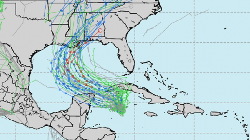
Honestly, I'm going to go crazy and forecast this thing becomes a moderate Cat 2. None of the intensity guidance shows that, and I care 0%. The environment is excellent and I don't see dry air entrainment. The eyewall that's developing is solid, and I actually think the outer bands are helpful in keeping the interior of the system more stable. Less chance for some unknown shear to work in, less chance for extra dry air to work in. Whatever happens here, it will absolutely beat the intensity guidance. As for why the guidance is low, few possible reasons but frankly my best guess is low initial intensity. I've watched the guidance forecasts all season and they rise and fall in line with the ingested initial intensity. The thing is, it does NOT take THAT much to get a storm to grow stronger in a low shear, high water temp, moist environment, and you have better than chance odds by betting above the model consensus. If the eye feature closes off, which it looks poised to do, ya know, go nuts.
As I've said all along, I'm definitely most interested in what this thing does inland when it phases with the continental low ejecting from the rockies. Very Isaias/Sandy-esq in the sense of baroclinic interaction maintaining strength for a LONG time. This storm won't produce 40" in a single spot, but the phasing is going to mean tens of millions of americans are going to see significant impacts from these storms. 2, 4, 6" of rain, some areas a couple feet of snow...these are large totals and will cause widespread spatially, but not dense, power failures, flooding, wind damage, etc over a HUGE swath of the eastern CONUS. Obviously you're also ingesting a bunch of vorticity, and if you take that, add some moisture, jet streak and a strong llj, you'll see a touch more tornado potential than with your average hurricane. Whenever a barotropic system phases with a baroclinic system, things get interesting.
MU
Red state sandy
-
 2
2
-
 2
2
-
 1
1
-
-
4 hours ago, NavarreDon said:
Hello!
There is no way that ends up being a quality landfall.
-
Gladys 68 redux
-
1
-
-
How many hours of good hurricane have we had this season? My guess is less than 100, with epsilon being 24 of that.
-
1
-
-
This year underachieved. That’s what I hate about it. It could have been so much better.
-
3
-
1
-
1
-
-
40 minutes ago, Tallis Rockwell said:
Solid B+ season. Good landfalls with some variety and plenty of impacted areas but full of junk storms. No Irma or Dorian this year.
This is accurate
-
4 minutes ago, hlcater said:
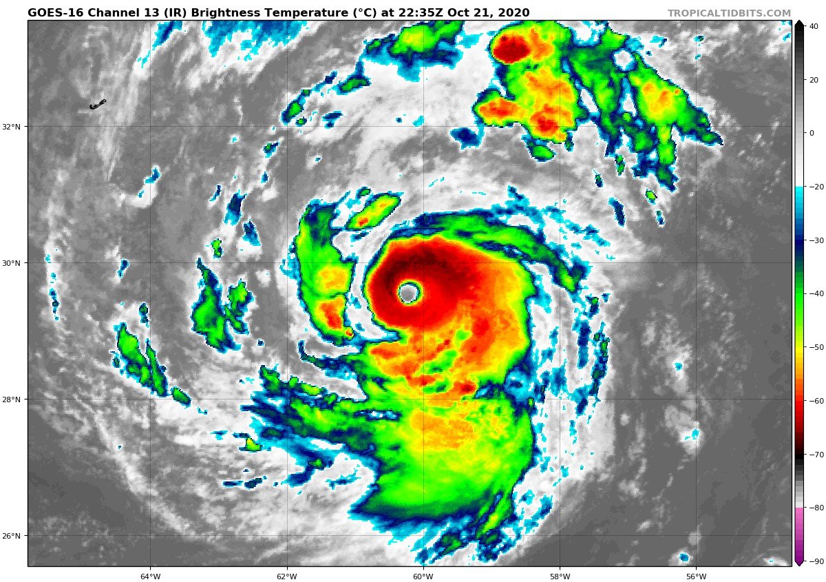
Very interesting to see what recon finds given satellite has only improved from earlier

Cool looking storm. I like it when they’re cute but have a broad envelope as well.
-
Lol. If this is what 2020 is like imagine a couple decades from now. Looking forward to Major Hurricane Upsilon’s landfall in the NeoAzores autonomous zone on Trumptember 12th, 2039.
-
Big yikes
-
30 minutes ago, Windspeed said:
That would be a nice board meltdown if it were to happen again.
-
1
-
-
-
4 minutes ago, wdrag said:
Hi! Been asked a question: Trying to save a little time... if someone here has an answer, could you reply. Thank you.
2005? Some sources have listed it as having 27 TS, others 28? Which is correct? Since there are 21 letters of the English alphabet used and the last storm that year was Zeta (6th letter of the Greek alphabet) wouldn't that mean there were 27 TS that year not 28?
Walt
there was an unnamed storm
-
 2
2
-
-
10 minutes ago, MJO812 said:

Thanks for the reminder that I am due a cool down. Might actually have some days in the 80s finally as flow amplifies and we get troughing in the west.
-
1
-
-
6 minutes ago, hlcater said:
Dont know where to put this so it goes here. Papin is now an NHC forecaster. Good for him
Good for Phil. He has been destined for that job for a decade now and it’s nice to know that in some governmental offices merit is still a thing.
-
4
-
-
6 hours ago, natedizel said:
Dude you probably have more people ignoring you than him. Haha
Yeah. I’m sure. A bunch of people who are here to post about “science” but what they really mean is you have to say nice things about the storms.
-
11 hours ago, Prospero said:
I do try to contribute quality more than raise an eyebrow now and then speaking what is truly on my mind. But hey, Truth (or possible Truth) is and has always been a scary and dangerous concept. We could go back hundreds of years and see examples of "conspiracy theories" being denied that were true and angered people only to learn in history how true they turned out to be. Even the weather modification experiments in the 60s were conspiracy theories until they were acknowledged.
I'll try to be more conservative.
")
I love this forum and hope I do not get banned altogether. GOL (ghost of leroy) is still here, so maybe I'll be OK even though on an ever growing list of ignores...
6 hours ago, Prospero said:Thanks TradeWinds, Florida neighbor.
I've been involved in internet forums since the 90's, alt this and alt that. I've been checked so many times I can't count. But manners are important, and timing is everything. When the discussions are barely active there is room for more personal input, like where to go for Sushi, etc., or occasional far-out ideas. But I do get excited when things are active and have posted inappropriately after a few beers when people are scrambling for their lives as a hurricane is approaching. I am not trying to be on ignore lists, and it hurts my "feeling" (as a good friend used to joke with me), but learning the expectations of any social environment is just part of growing up and belonging to a group. If I am ignored, it is my own fault. Someone making a point of it publicly may or may not be seeking attention, it may be directed totally at me to "behave" which I get. My skin is thick, by experience! When I get to the point of not learning or taking criticism, then I am trouble.
Second part, in Tampa Bay we've been in so many models with powerful storms predicted several days out that we are getting numb. That is foolish, as this is 2020 and only mid-October. We do know we may be preparing for a storm even up to Thanksgiving. But it is weird we have not been in an actual Tropical Storm or Hurricane warning this year. That might even make it more likely we could get slammed at the last minute to fully complete 2020. (Ooooops crazy talk again!)
") 5 hours ago, Prospero said:
5 hours ago, Prospero said:We've had TS winds at moments and gusts several times here at 50+ mph with some of the storms, a few mild storm surges, and beautiful roller waves several times from several Gulf storms. We were in five-day cones a few times, but never a warning.
18z GFS has the latest storm going over Cuba and out to sea. But each day brings new models.
Funny how the models always have perfect eyes. That is the problem with the models, the computers don't know how to throw a fly into the mix. Especially in 2020 with perfect eyes being so rare with random flies always messing them up.
Your biggest problem is all these paragraphs. That’s the real reason people want to ignore you. If you are efficiently conspiratorial people won’t care.
-
1
-
-
2 hours ago, hlcater said:
I remember when people, including myself, thought this was gonna rip a hole in space-time in the W Carib. Fun times.
sub 900

-
2
-
-
1 minute ago, VortAmplifier said:
20-25MPH sustained 35-40MPH wind gusts lower-upper 850mb winds 50MPH could mix down in the strong cells... These are the remnants coming in NYC Metro Area on Monday next week ; rainfall 2-3in


wow
-
1
-
-
3 hours ago, Ginx snewx said:
a porta potty slowly blowing around is the perfect metaphor for delta
-
1
-
-
Just now, Ginx snewx said:
These guys just got trapped on some ramps with 10 feet of surge
Im sure they are gathering valuable data for the public and scientists
-
I don’t know why any of us had the fantasy that this was going to come in as anything but a cat 1, maybe fake cat 2.
-
1 hour ago, CheeselandSkies said:
Because seeding doesn't work. They thought StormFury was working, then they figured out EWRCs and dry air intrusions were a thing.
If “they” were trying again they wouldn’t tell “us”. Too many national security and bad press implications.
I am not sure we should give up on geoengineering and messing with hurricanes just because a mid 20th century program was a failure.
-
1
-
-
On to the next one.
-
13 minutes ago, Windspeed said:28 minutes ago, olafminesaw said:Yeah,the point being, it was basically assumed before the past couple years that landfalling gulf canes were half-canes
Those folks had short memories. Even after Camille, Frederic and Alicia weren't that long ago and made landfall with closed eyewalls. At any rate, Delta likely will not be a good example of a closed eyewall at landfall by any stretch. Unless 2020 deals to us something completely wack.
I forget which piece of research it was and it’s probably a decade old, but the conclusion that I read that stuck with me is that upon approach, weak hurricanes tend to strengthen the most and strong hurricanes tend to weaken the most and 85-95 knots is kinda the sweet spot for the NGOM


Hurricane Zeta
in Tropical Headquarters
Posted
Katrina didn’t hit NOLA. It slid East. There is no evidence the city got anywhere near 115-120 sustained. Power failures led to fewer reports than average but the consensus was cat1, maybe cat 2 winds for the city itself.