Blue_Ridge_Escarpment
-
Posts
2,200 -
Joined
-
Last visited
Content Type
Profiles
Blogs
Forums
American Weather
Media Demo
Store
Gallery
Everything posted by Blue_Ridge_Escarpment
-

Mid to Long Term Discussion 2021
Blue_Ridge_Escarpment replied to jburns's topic in Southeastern States
28.5 here currently after bottoming out at 14 this morning and it feels about like 60 without the 50 mph winds we had yesterday. -
Mid to Long Term Discussion 2021
Blue_Ridge_Escarpment replied to jburns's topic in Southeastern States
Been the theme of the day so far. Not surprising for a CAD event getting within 48 hours. -
Mid to Long Term Discussion 2021
Blue_Ridge_Escarpment replied to jburns's topic in Southeastern States
Icon is similar if not colder. And the icon is usually too warm at the surface. -
Mid to Long Term Discussion 2021
Blue_Ridge_Escarpment replied to jburns's topic in Southeastern States
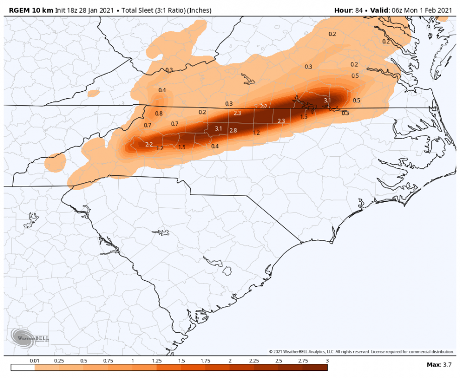
3k NAM got rid of the splotchy precip look and really beefed up the amounts. -
Mid to Long Term Discussion 2021
Blue_Ridge_Escarpment replied to jburns's topic in Southeastern States
I’ve seen this before. 9/10 CAD events
-
Mid to Long Term Discussion 2021
Blue_Ridge_Escarpment replied to jburns's topic in Southeastern States
3k NAM coming in much colder through 6Z Sunday. -
Mid to Long Term Discussion 2021
Blue_Ridge_Escarpment replied to jburns's topic in Southeastern States
Look at the 12Z HRRR -
Mid to Long Term Discussion 2021
Blue_Ridge_Escarpment replied to jburns's topic in Southeastern States
Yikes. I’m hoping to hold onto snow/sleet longer than forecasted. With the wind today and tonight, I’m guessing these trees are pretty weak. -
Mid to Long Term Discussion 2021
Blue_Ridge_Escarpment replied to jburns's topic in Southeastern States
Excellent first post. Definitely a good representation of how the GFS is trending. -
Mid to Long Term Discussion 2021
Blue_Ridge_Escarpment replied to jburns's topic in Southeastern States
Do a loop of the last 3 runs for surface temps and you can see how it’s folding. 2-3 degrees colder each run. -
Mid to Long Term Discussion 2021
Blue_Ridge_Escarpment replied to jburns's topic in Southeastern States
Puts wncsnow and I in some heavy snow there too. -
Mid to Long Term Discussion 2021
Blue_Ridge_Escarpment replied to jburns's topic in Southeastern States
NAM has a dry bias now actually. -
Mid to Long Term Discussion 2021
Blue_Ridge_Escarpment replied to jburns's topic in Southeastern States
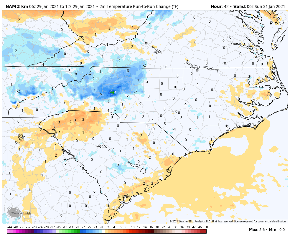
3k NAM has me around 26 with precip rolling in. -
Mid to Long Term Discussion 2021
Blue_Ridge_Escarpment replied to jburns's topic in Southeastern States
Yeah it’s folding like a dish rag. -
Mid to Long Term Discussion 2021
Blue_Ridge_Escarpment replied to jburns's topic in Southeastern States
-
Mid to Long Term Discussion 2021
Blue_Ridge_Escarpment replied to jburns's topic in Southeastern States
Probably the worst driving conditions possible if that came to fruition. -
Mid to Long Term Discussion 2021
Blue_Ridge_Escarpment replied to jburns's topic in Southeastern States
Yep. And the two 18Z models we have so far have trended the LP south and weaker. Less warmer air to be wrapped up into us. -
Mid to Long Term Discussion 2021
Blue_Ridge_Escarpment replied to jburns's topic in Southeastern States
18Z ICON much colder. Looks like it might actually stay all snow for the mountains and immediate foothills. Waiting on better maps to come out to see for sure. -
Mid to Long Term Discussion 2021
Blue_Ridge_Escarpment replied to jburns's topic in Southeastern States
Has my location around 25 at the start of precip. Yikes. -
Mid to Long Term Discussion 2021
Blue_Ridge_Escarpment replied to jburns's topic in Southeastern States
For sure. Wedge holds longer too. Morganton snuck above freezing last run around 18Z Sunday. This run it’s around 31 all the way through 21Z -
Mid to Long Term Discussion 2021
Blue_Ridge_Escarpment replied to jburns's topic in Southeastern States
Wedge more pronounced this run for sure. See if it holds -
Mid to Long Term Discussion 2021
Blue_Ridge_Escarpment replied to jburns's topic in Southeastern States
18Z NAM at hour 42 has a 1mb stronger high than previous run and in a better position as well. We’ll see where it goes. -
Mid to Long Term Discussion 2021
Blue_Ridge_Escarpment replied to jburns's topic in Southeastern States
Yeah that southeast ridge has taken a beatin all winter. -
Mid to Long Term Discussion 2021
Blue_Ridge_Escarpment replied to jburns's topic in Southeastern States
After today and the next week I might be ready to torch. -
Mid to Long Term Discussion 2021
Blue_Ridge_Escarpment replied to jburns's topic in Southeastern States
Canadian is stuck for me at 24 on all outlets I’ve tried. Where did you get yours?