

BGM Blizzard
-
Posts
1,676 -
Joined
-
Last visited
Content Type
Profiles
Blogs
Forums
American Weather
Media Demo
Store
Gallery
Posts posted by BGM Blizzard
-
-
12z EPS mean for early week storm...
.thumb.png.fa53c84cd627b7893e67ae2ee002bb26.png)
-
1.8" here so far. After a bit of a lull some more precip is about to move in.
-
WSW upgrade for all of Oneida County for 5-8.
-
 2
2
-
-
Steady snow with fluctuating flake size here. Temp fell from 29 to 26 since precip arrived. About 0.5" so far.
-
1
-
-
41 minutes ago, tim123 said:
Got 18z euro
10:1

Kuchera

-
 1
1
-
-
12z EPS mean qpf for the early week storm. Definitely has potential to deliver the goods for a large swath of upstate...

-
0z EPS mean for late Monday-wednesday storm...

-
12z EPS mean qpf for mon-tue storm...

-
2
-
-
1 hour ago, Syrmax said:
Where in the hell did that line come from? Completely misses everyone but southern tier in central NY. Unbelievable.
It's hitting here now and there a reason why BGM not even issuing an SPS for it because its more impressive on radar than it actually is. My temp actually rose from 29 to 32 so it's hardly even sticking to the pavement. Probably only going to amount to a half an inch is all.
-
1
-
-
Anyone know what's up with the GFS parallel not loading completely or at all for certain runs over past few days? Is it an issue with pivotal weather site or is it the model itself?
-
12z EPS mean QPF for the mon-tues storm...

-
4 minutes ago, rochesterdave said:
NAM does same thing

Appears the Nam is chasing convection out in the Atlantic. Looks very suspect.
-
1
-
-
18z Euro looks better for CNY folks compared to 12z. Seems to have picked up on some lake enhanced wrap around.

-
1
-
1
-
-
-
4.3 inch total here

-
2
-
-
About 4 inches of paste here and still coming down. This little event overperformed a bit vs the model consensus.
-
2
-
-
28 minutes ago, BuffaloWeather said:
From @OHweather
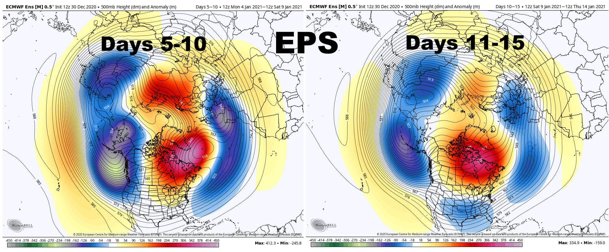
The very strong positive East Asian Mountain Torque (the very strong high pressure over eastern Asia) which is causing our strong Pacific jet stream and flood of mild air, but is also contributing to the developing strat warming event, is hinted to begin weakening in the the 7-10 day:

This causes the trough to begin retrograding across the northern Pacific as the Pacific jet begins to pull back a bit. As a result, both the GEFS and EPS begin raising heights in the 10-15 day range on the West Coast of the US and Canada:
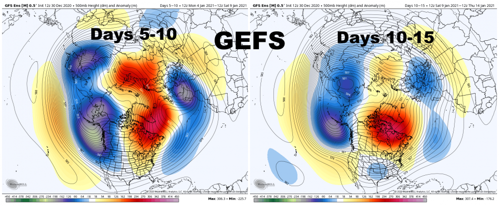
With an active sub-tropical jet and developing split flow over the western U.S., along with a persistent, west-based -NAO, this would begin increasing the risk for winter storms across the eastern and central U.S. around or just after January 10th. It would not immediately be a very cold pattern, but it could be a snowy one for some areas.
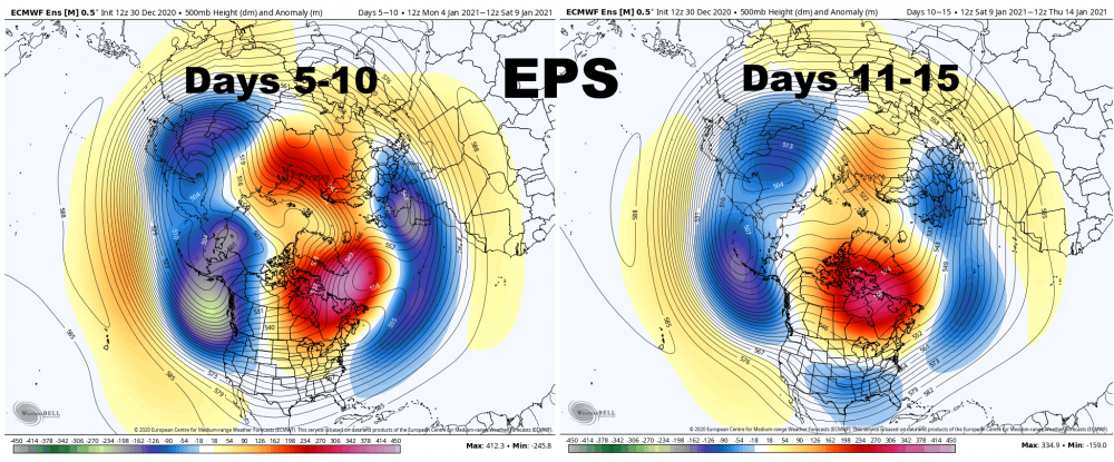
The EPS continues to retrograde the trough into northeast Asia in the 10-15 day range while the Pacific jet continues pulling back. I'm not sure this lasts long, but could give a window for ridging into Alaska after mid-month. With a split flow over the western US and continued -NAO, a window of ridging over Alaska could both introduce colder air, but also lead to a quite active pattern for the Ohio Valley and southern Great Lakes into the Northeast beginning around or just after the middle of January.
.gif.de6b65be41887373a5f8da892c5f0858.gif)
This is still a long way's out, but signs point to a better Pacific pattern soon. Given the -NAO in place slowing down any storms over the eastern 2/3rds of the CONUS, all we need is a somewhat cooperative Pacific to have some fun.
Jim Sullivan is the long range forecaster at Weather Works in NJ. Always has great insight on this stuff.
-
1
-
-
Looks like LEK nailed it with his forecast tonight and saying the event would overperform. That band looks like it means business.
-
Still about 12" of snow pack here but melting at a good clip. Creeks are starting to overflow their banks.
-
2 hours ago, BuffaloWeather said:
More then 9", what a weird number.

9" is the criteria for watch/warning over a 24 hour period in the NY portions of the Buf, Bgm, and Aly cwa. Probably Btv too.
-
8 minutes ago, lakeeffectkid383 said:
You guys should be alright with 1-2” of rain. You guys “only” had about 2” of QPF in the event. In Nov 2014 there was upwards of 6” of QPF in the 70-90”+ that fell over the course of 3 days, then was followed up with several inches of rain and everything fared okay flood wise. There was roof collapses but many of those started before the rain came from the snowpack itself. Hopefully you guys don’t have to worry about roof collapses with the lesser amount of snow/QPF and the amount of time between the end of the snowstorm yesterday morning and if/when the heavy rain comes next week.
Yeah flooding would probably be limited to poor drainage type stuff, but definitely would be concerned about roofs. There were already some roof collapses of mobile homes just from the snow. I would probably clear my garage roof off just for precaution if it ends up we are looking at something significant a few days out. I think I read KBGM recorded 2.71 of liquid equivalent from the 40" of snow, hopefully we shed some of it before next storm.
-
1
-
-
I don't know what would be worse for BGM area regarding potential storm next week... 12+ of snow or 1.5+ of rain. Alot of side streets still haven't been made passable yet. I'd be okay with BGM missing out on any sig snows, but don't want much rain either and have to clear my garage roof. Ugh.
-
-
Town highway dept was finally able to get personnel to the barn and get the front end loader out. Just made my street passable. I took a video but it's too large to upload... about 2:30 long.
.png.5cc432692e3317a691d829ae1f171a70.png)


Upstate/Eastern New York
in Upstate New York/Pennsylvania
Posted
UK is still suppressed well south. Euro will probably show something similar again as well I'm guessing.