Icy Hot
-
Posts
187 -
Joined
-
Last visited
Content Type
Profiles
Blogs
Forums
American Weather
Media Demo
Store
Gallery
Posts posted by Icy Hot
-
-
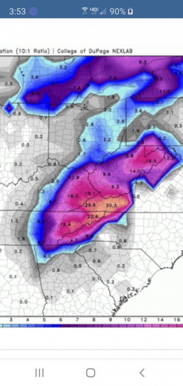
Thanks so much. That was really educational!
-
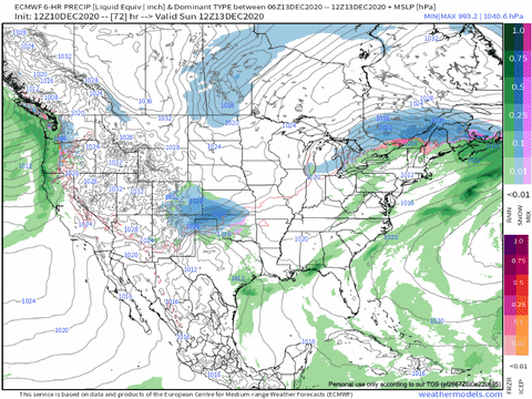
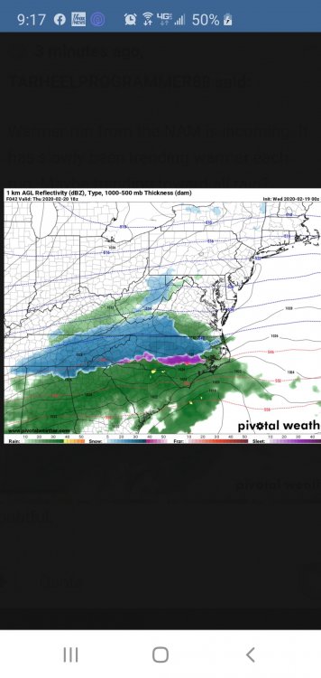
Can you explain this chart to me Tellico?
I've never figured out how to read these.
-
 1
1
-
-
Not going to make today's predicted high of 35. At 3 p.m. it is only 26. Snowpack is doing a great job.
-
3
-
-
Just now, Carvers Gap said:
It is flat ripping flakes here in Kingsport right now.
The main band is almost thru.
-
1 minute ago, Carvers Gap said:
TRI crew...looks like the 21z HRRR has bumped our totals. 18z RGEM was excellent as well. Ice and snow being wind driven currently between 20-30mph.
By how much? Temp is finally falling. Now 42.
-
Temp went up 2 more degrees in Colonial Heights. Now 52.
-
2
-
-
When did WSW criteria change? I thought it was 6" or more for our area? They are calling for 2-4??? This is straight from NOAA.GOV - A Winter Storm Warning indicates that heavy snow of at least 6 inches in 12 hours, or at least 8 inches in 24 hours, is expected. It can also be issued if sleet accumulation will be at least half an inch.
-
Really surprised we don't have more chatter here. It has been a long time since we've been under a Winter Storm Watch. Combine that with the extreme cold that is on the way and the fact it is coming on Christmas Eve; I thought this forum would be hopping.
-
1
-
-
And where is that? Details???
-
We have flurries in Colonial Heights and a dusting on the ground.
-
3
-
-
40 minutes ago, Holston_River_Rambler said:
I'm starting to become even more bearish than Jeff for the plateau, for the Monday deal:
Even though it is coming through overnight, and even though as Carver's mentions its a great low track, it's a rainer. Hopefully the energy can get a tad more wound up and pull a wee bit more cold in. Otherwise, it might just end up being a 3000 ft + event.
Wishcast alert: Perhaps it will develop a couple hundred miles further south and round the pan-handle.
-
 2
2
-
-
48 degrees at 8:48 on Sept. 30 in Kingsport. High today is predicted to be 68. Last year we set our record high for yesterday at 93. What a difference a year can make!
-
1
-
-
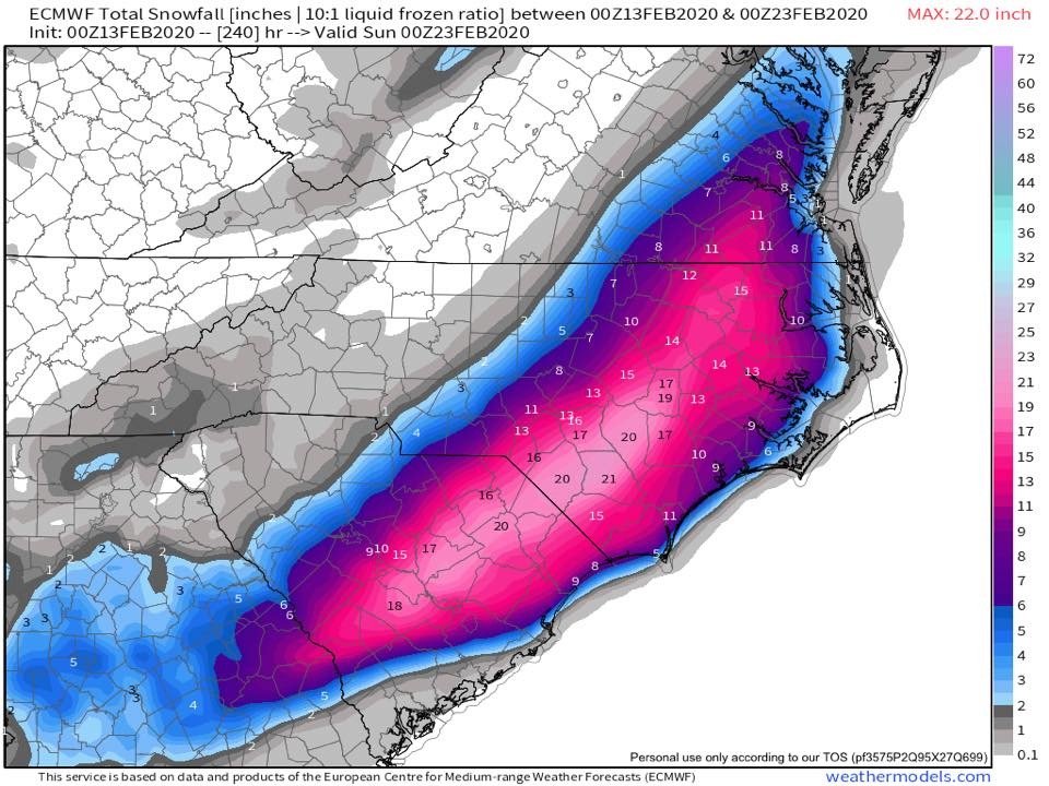
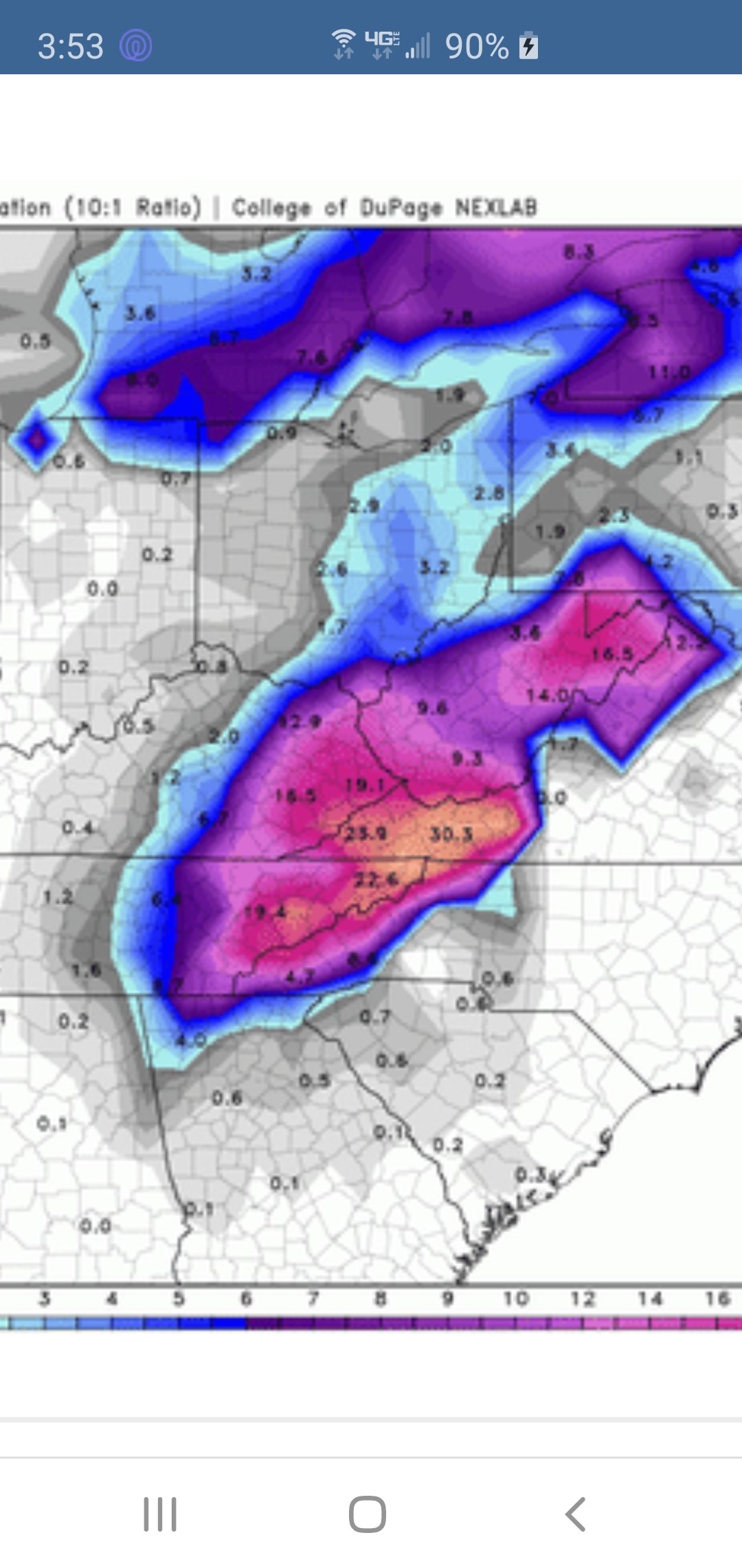
How's this for a midrange forecast? Way too soon to know what happens but fun to look at.
-
Radar not impressive at all this morning.
-
MRX says ip to an inch for the valley.
Special Weather Statement
Special Weather Statement
National Weather Service Morristown TN
334 AM EST Wed Feb 26 2020

TNZ012>017-035-042-044-046-VAZ001-002-005-006-008-261900-
Scott-Campbell-Claiborne-Hancock-Hawkins-Sullivan-Morgan-
Northwest Greene-Washington-Northwest Carter-Lee-Wise-Russell-
Including the cities of Big South Fork National, Oneida,
Smokey Junction, Elgin, Huntsville, Norma, Slick Rock, Fincastle,
La Follette, Elk Valley, Jellico, White Oak, Caryville,
Royal Blue, Lone Mountain, Sandlick, Springdale, Arthur,
Harrogate-Shawanee, Clairfield, Howard Quarter, Evanston,
Sneedville, Treadway, Kyles Ford, Mooresburg, Kingsport,
Bristol TN, South Holston Dam, Pine Orchard, High Point, Petros,
Greeneville, Johnson City, Elizabethton, Rose Hill,
Big Stone Gap, Norton, Wise, Coeburn, Appalachia, Pardee,
Hiltons, Hansonville, Lebanon, Dye, Castlewood, Honaker,
Rosedale, Benhams, Bristol VA, and Abingdon
334 AM EST Wed Feb 26 2020

...Wintry Conditions Expected Late Today into Tonight...

Rain will develop today as a frontal boundary moves across the
region. The periods of rain will change over to snow by mid to
late afternoon over some of the higher elevations, with a change
to all snow showers even in valley areas tonight.

Snowfall amounts of up to an inch will be possible across the
Northern Plateau, Southwest Virginia, and Northeast Tennesee by
late tonight, with higher amounts up to 2 inches over some of the
higher elevations.

Travel may become difficult due to snow covered roads and reduced
visibility especially over the higher elevations. If you must
travel, use caution while driving.

Stay tuned to NOAA Weather Radio and other local media for
further details or updates.
-
 1
1
-
-
34 and moderate snow in Colonial Heights.
-
1
-
-
NE TN will be below freezing Wednesday night, so ground temps should accommodate any snow that does fall.
-
3 hours ago, jjwxman said:
Glory hallelujah the European model finally throws us a fantasy bone.
Just browsing this forum but wow! When is the last time South Carolina had anything like this verify?
-
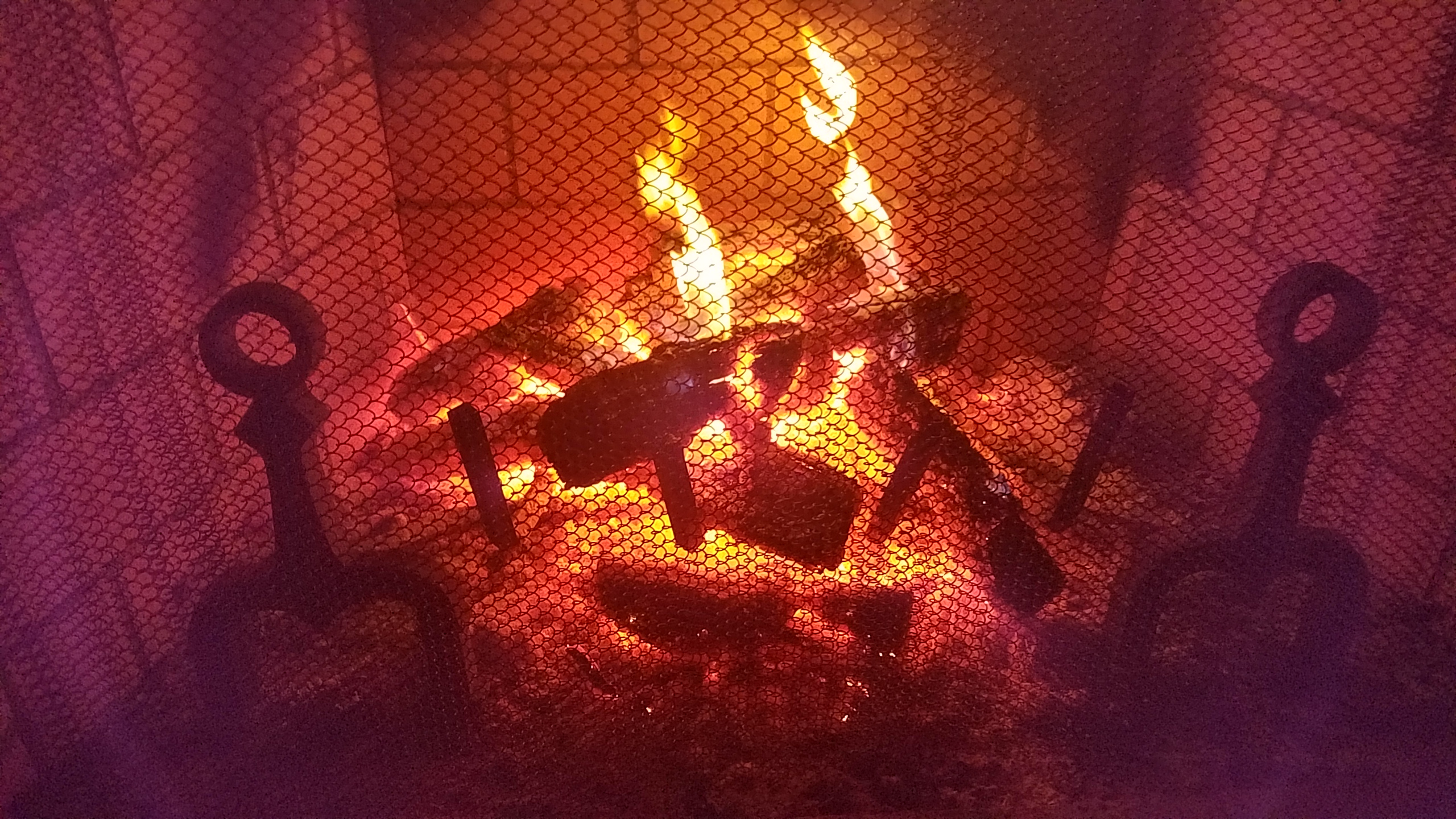
After all this warmth, looking forward to 18 degrees Friday night and a crackling fire.
-
2
-
-
Moderate snow and 35 in Kingsport.
-
1
-
-
44 and heavy rain in Kingsport. Temp dropped 10 degrees in last hour.
-
Too bad that snow isn't coming predominantly at night. We will take whatever we can get.
-
1
-
-
-
3 hours ago, Holston_River_Rambler said:
I've got some friends hiking up LeConte today and will ask them what they saw when they get back.
I had some sleet this AM.
We had sleet and snow for about 30 mins in Kingsport.
-
1
-

January 7 - 8 ULL potential
in Tennessee Valley
Posted
National Weather Service MRX is still not impressed. Only saying 50% of snow for KTRI.