
Icy Hot
-
Posts
187 -
Joined
-
Last visited
Content Type
Profiles
Blogs
Forums
American Weather
Media Demo
Store
Gallery
Posts posted by Icy Hot
-
-
18 minutes ago, PowellVolz said:
So close but so far away. Not a good look at all for most of the valley
.Go south and east please...
-
 3
3
-
-
5 minutes ago, BuCoVaWx said:
This should check out considering the snow hole over top of me. Surrounded by high accumulations all around lol
I second that. Tired of Sullivan Co getting screwed. lol
-
2
-
-
7 hours ago, Dsty2001 said:
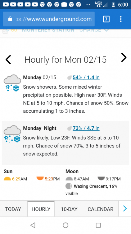
What I find funny is everybody around my area is convinced we are getting a 93 repeat, and all I can do is shake my head and ask where the heck they are getting that information from. Interesting enough a local news station was saying up to a foot is possible which threw me aback, the models don't seem to be in any agreement right now and honestly I don't think we will know for sure to right before the event starts
AccuWeather says 8-12 inches for Kingsport on Sunday night. Lol
-
 2
2
-
-
Been a long time since we've had a Clipper
-
2
-
-
Our local met said it was classic warm nose.
-
2
-
-
Finally getting some goods in Kingsport. Ground is white, temp is 33.
-
6
-
-
13 minutes ago, RawCrabMeat said:
You think Maryville looks more similar to Knox or the southern valley/madisonville for this system
Seems latest radar returns show dry air coming up from the south around Nashville area. Check and see if you agree. Dry slot is advancing.
-
Sprinkles and 34 in Colonial Heights, just southeast of Kingsport. Storm is racing thru the state.
-
 1
1
-
-
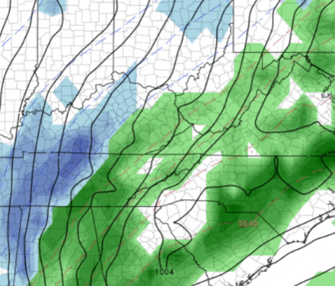
Odd looking snow holes in Sullivan and Washington counties.
-
Colonial Heights never got cold enough. Snow is winding down and temp just now hit 32. Though it snowed very hard for several hours, we only have a dusting.
-
1 hour ago, Holston_River_Rambler said:
Sorry, I would normally do a single post for 6z, but the NAMeve gets a special one.
6z GFS was even better, especially for NE TN and SW VA:
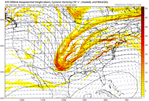
NOAA says No ah, NO!
-
1
-
-
Remember everyone, Winter does not begin for 3 more days. DECEMBER 21. :)
-
3
-
-
Just a friendly reminder before everyone gets warm winter depression. Winter doesn't begin until December 21. Lets enjoy the current below norm temps and chase a chance of snow Thanksgiving night.
-
4
-
-
This morning's 34 will feel quite balmy with tomorrow morning's predicted low of 21! Brrrr
-
Round 4 or 5, just reached Kingsport. Strongest gusts yet, more heavy rain and several lightning flashes. When the sun comes up it wll be interesting to see how much tree damage occurred from the 2:30 a.m.storm.
-
 1
1
-
-
Round 2 just went thru Kingsport. 47 mph wind gusts, heavy rain. Easily exceeded the 1/2" predicted for today.
-
2
-
 2
2
-
-
Just had 2 cells move thru Kingsport. One 2 miles to the North brought a deluge, multiple lightning strikes and pea-sized hail.
-
1
-
2
-
-
All the while NE TN will be mid to upper 40s and even 50s all next week. Time to put out grass seed.
-
35 minutes ago, Wintersnow888 said:
What's the location?
-
1 hour ago, Daniel Boone said:
The old killer, "Tn Valley effect". as dubbed years ago .
Could the warm nose really reach all the way into OHIO? Seems overdone.
-
Wow look at that convection from the GOM feeding into NC. What a frozen tundra that would be!
-
So once again the cold gets pushed back for East TN. MRX a.m. disco- "Models are keeping more of the colder air to our north and northeast"
-
MRX says no frozen precipitation in NE TN Valley this week. Wish it were false, but it is what it is.
-
9 minutes ago, Carvers Gap said:
0z NAM (3k and 12K) have run...
And???
Jan 16-17th Boom or Bust
in Tennessee Valley
Posted
We still have 24 -48 hours. Things could change. Even if it rains, a beauty of a storm to watch unfold.