
Icy Hot
-
Posts
187 -
Joined
-
Last visited
Content Type
Profiles
Blogs
Forums
American Weather
Media Demo
Store
Gallery
Posts posted by Icy Hot
-
-
41 minutes ago, Carvers Gap said:
MRX morning discussion....
Key Messages:

1. Extreme cold that has not been seen in this area for decades
will build into the area on Thursday night and continue through
Saturday.

2. Expected impacts from this extreme event will be gusty winds
that may cause power outages, potentially hazardous road
conditions from snow/ice, and dangerous wind chills.

The arrival of an extremely cold air mass continues to be the big
story for this period. From 00Z Fri to 12Z Fri, most of the area
will see around a 30-40 degree drop in temperatures. The cold
front will move through quickly, from around midnight to 4 AM, and
dry air aloft builds in a few hours after surface fropa. So there
will only be a small window when there will be potential for snow
accumulation, which appears to be from 06Z to 12Z. For the most
part, the SREF and NBM members have mostly settled on snow
amounts from about a quarter inch to one inch for the Valley, with
up to 2 inches in the higher elevations and SW VA, and the
forecast amounts will fall in this range. Outside of some light
snow showers or flurries adding a tenth or so in the mountains and
SW VA, accumulating snowfall will mostly end by 12Z. As we have
been emphasizing the past few days, despite the light snow
amounts, travel in the area may be impacted by the rapid drop in
temperatures causing any moisture on roads to quickly freeze. Icy
road conditions may persist through Friday and potentially through
Saturday as well, since max temperatures will be in the teens and
20s.

With the frontal passage will come a sharp increase in winds, with
sustained winds expected to be in the 15-30 mph range with gusts
in the 40s, and near 50 mph in the mountains. A concern with these
winds will be the potential for downed trees and power lines
leading to power outages when temperatures will be getting
extremely cold. Wind chill values on Friday will be below zero
for the entire area through Friday and Friday night, and -15 to
-25 in the mountains, Cumberland Plateau, and SW VA. Therefore, a
Wind Chill Watch will be issued for the entire area from 09Z Fri
through 18Z Sat. The TN Valley may end up in a Wind Chill
Advisory, but at this point, will have a blanket Watch and let
later shifts divide it by topography for an Advisory/Warning.

Bottom line, this will be an impactful, extreme cold event that
has not been seen in this area for decades.

The rest of the forecast period will be dry with a gradual warming
trend.
Am I missing something? They say "cold not seen in decades." We've been to -4 at least 3 times within the last 10 years in NETN. Are they just not looking at historical data anymore?
-
 2
2
-
-
-
40 minutes ago, Runman292 said:
Good morning, everyone. It's been a while since I've last been on here. I'm sorry that I haven't been posting since last winter, but I've had a pretty rough year. In February, I started getting daily headaches and migraines out of nowhere. I've had a few migraines that have mimicked strokes, which was really scary. On top of that, my wife had a "widow maker" heart attack at the age of 33 in June. I'm hoping that 2023 will be better for me and my wife, and that we get a lot of snow this winter.
Welcome back and may you be blessed with good health next year!
-
1
-
-
8 hours ago, Matthew70 said:
I don’t see ads at all.
I'm on the app in Chrome on a Android phone. None of these ads were here last year but now every page of posts is flooded by ads.
-
I love our forum but the constant flow of ads is ruining it. Absolutely drives me nuts with ads popping every 5 seconds.
-
Colonial Heights 48 degrees with heavy graupel.
-
4
-
-
23 hours ago, Holston_River_Rambler said:
So, snow showers Saturday night and Sunday? Looks like there could at least be a dusting for that ever-favored area in western Cumberland County we talked about earlier in the year.
If the MRX snow map is correct, looks like a dusting to .5 will be very common across NE TN.
-
4
-
-
Crickets in here. Everyone must be outside enjoying Spring!
-
2
-
 1
1
-
-
4 minutes ago, PowellVolz said:
I’m really concerned with some of my shrubs for Sunday morning, especially my Jap Maple and Cherry tree. Would 2 or 3 inches of snow on them be enough insulation? Or should I cover them Saturday night, Sunday morning?
.Why chance it?
-
4
-
-
Let's hope we are locked in and loaded on Friday models.
-
3
-
-
Beautiful sunny day. Wind makes it feel much colder than 47. Noticed lots of ice crystals in the shade. The ground is still quite cold.
-
2
-
-
2 minutes ago, fountainguy97 said:
Think our chances of cashing in on the bomb are down toward zero at this point. We need a 250mile+ shift west with the timing of negative tilt to even be in the game.
E TN could still get some overunning/NW flow from this but even then looks to end up on the lighter 2-4inch side of things
But FT do you realize 2-4 would be epic for those of us in TRI who keep getting shut out.
")
-
2
-
-
Ye forget the epic shows we've had in Feb and March in years yonder past.
-
 1
1
-
-
5 hours ago, nrgjeff said:
Auburn got it done on CBS! Did they get in? Camping out for basketball takes me back to college, and some cold days in Lawrence, Kansas.
And since UT Chatt didn't cover the spread, I'll double down on Kansas. Not necessarily responsible gaming, but it seems like the thing to do, ha.
LSU at Tennessee should be another barn burner. Great to see all this excellent basketball across the SEC!
Who knew TN would smoke LSU??? GO VOLS!
-
3
-
-
I shared this in Obs thread but wanted your feedback. Rain and sleet in Kingsport. Temp is 37, no where near the 49 forcasted high. Wonder if this bodes well for quicker changeover in the a.m.?
-
Rain and sleet in Kingsport. Temp is 37, no where near the 49 forcasted high. Wonder if this bodes well for quicker changeover in the a.m.?
-
1
-
-
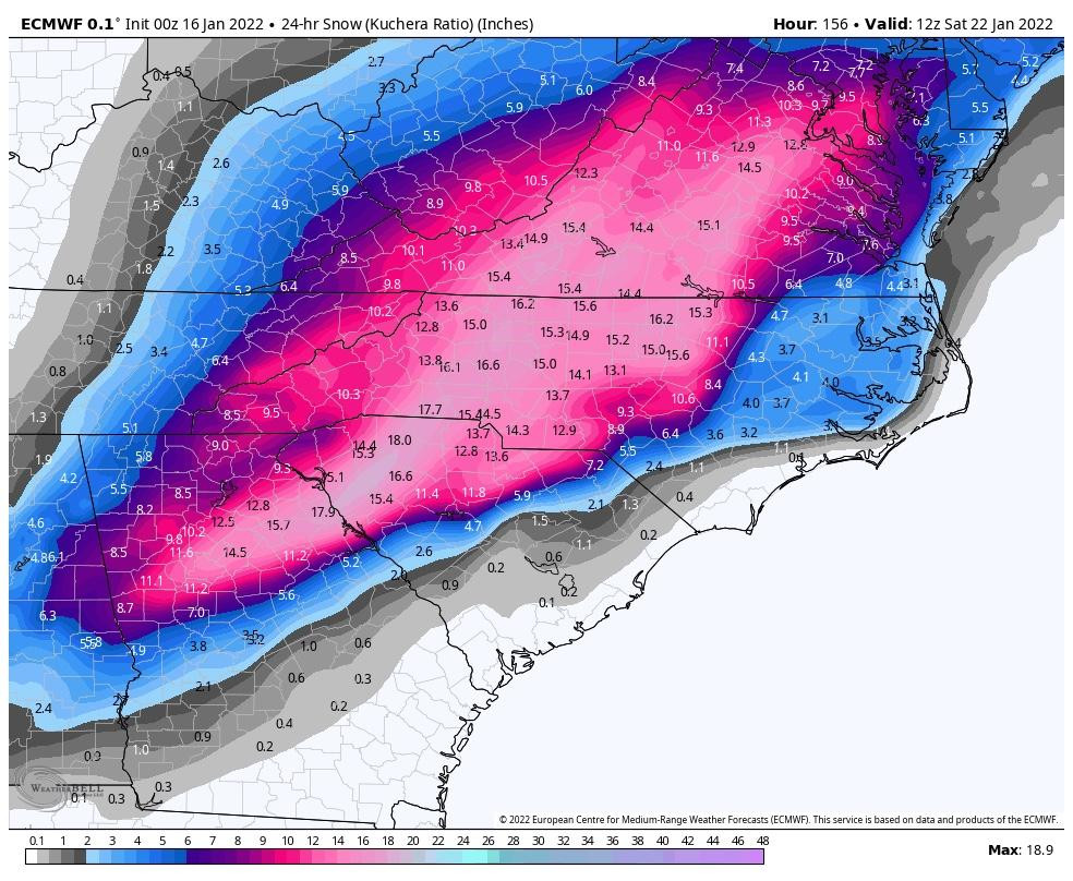
4 minutes ago, Carvers Gap said:
Here is the 24 hour Kuchera for folks to our south to see. The other image cut those totals off. It also eliminates previous snow fall from the remnants of today and also TR. It does not encompass the snowfall that continues to the NE. This is a solid, historical track verbatim.
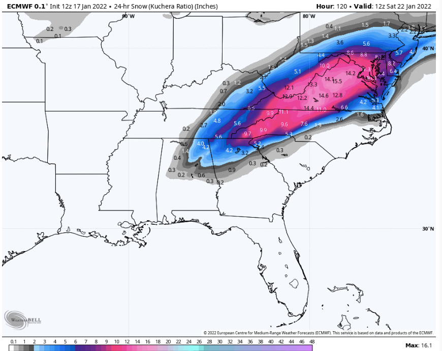
Wonder why MRX is down playing this?
-
Very interesting the temp has fallen from 34 at 6:30 to 30 now at 9:23 in Kingsport.
-
2
-
 1
1
-
-
6 hours ago, John1122 said:
Euro managed to creep west with the next potential event. Still buries NC but has a 3-6+ from the West side of the Plateau East to the mountains. Super cold, high ratio snow if it happens like it was shown.
Perhaps redemption for E TN???
-
1
-
-
Warm nose has made it all the way to the VA line now. Sleet and 34 here.
-
1
-
-
Moderate snow just began in Colonial Heights and 33 degrees.
-
21 minutes ago, ShawnEastTN said:
We need a lot of different things, track being probably primary issue to strength, don't want the surface low tracking too close. We want dynamic cooling to be stronger than any effects of warm nose and/or downsloping (if you are in the Eastern valley). We want the cold to filter in fastest possible.
Sent from my SM-G965U using Tapatalk
We just need all 6 winning lotto numbers. Lol
-
2
-
2
-
-
1 hour ago, Bigbald said:
The period of next weekend continues to look intriguing. 12z CMC drops a 1050 high out of Montana and suppresses a storm just to our south, although Chattanooga would get scraped. Prior 12z cmc run had this compromise I think, although the storm was more modest.
After that it's pipe bursting cold. Suppose the high is a little weaker and the cold front a little slower it would be a great setup for alot of us, from my novice eyes (paging Carver).
Edit to add: could Miami really get that cold?

But it's the CMC...
-
9 minutes ago, PowellVolz said:
.With no indicators on the left and right of these charts, very hard to determine what is being presented
January 2023 Medium/Long Range Pattern Discussion Thread
in Tennessee Valley
Posted
Especially considering the Vols won the Orange Bowl last night!