
PowellVolz
-
Posts
3,587 -
Joined
-
Last visited
Content Type
Profiles
Blogs
Forums
American Weather
Media Demo
Store
Gallery
Posts posted by PowellVolz
-
-
Mine isn't far off but it's a random chance of rain mixing in between 9 and 10pm.
Friday
A 40 percent chance of snow, mainly after 2pm. Mostly cloudy, with a high near 37. Southwest wind 5 to 10 mph.
Friday Night
A chance of snow showers before 9pm, then a chance of rain and snow showers between 9pm and 10pm, then a chance of snow showers after 10pm. Mostly cloudy, with a low around 31. West wind around 10 mph. Chance of precipitation is 50%. New precipitation amounts of less than a tenth of an inch possible.
Saturday
A chance of snow showers before 4pm, then a chance of sprinkles. Mostly cloudy, with a high near 38. West wind around 10 mph. Chance of precipitation is 30%.
Kinda wild that the southern valley west of Chattanooga is in a better location than you. Maybe not better but in a more favorable location this go around.
.-
 1
1
-
-
I know El Niños aren't notorious for alot of cold air, but we still have a ways to go to get a legit cold air source cold enough for snow and ice sleet here imo
Getting some snow pack to our N/NW should help. Maybe not a lot of help but it won’t take much with highs around 40.
.-
1
-
-
Hmm looking at that chart from Nashville, looks like Cumberland county towards Crossville would be pretty easy? Take 40 and hit the highway?
Again, for someone who has never seen snow, just it falling with some white grass is enough. Odds that area is a good hit? Don't know how they typically do in these set ups.
Just found out I’m getting off a 1/2 day tomorrow. I might head towards the plateau or maybe the Cherohala Skyway in Monroe Co.
I’ve got a Jeep Wrangler with 35/12.50’s. It’s pretty incredible how well it handles in the snow.
.-
4
-
-
MRX zone forecasts sometimes make no sense at all lol…for my location.
“Friday
A chance of rain and snow before 5pm, then a chance of rain. Mostly cloudy, with a high near 42. Southwest wind 5 to 10 mph. Chance of precipitation is 30%.
Friday Night
A chance of snow showers before 8pm, then a chance of rain and snow showers between 8pm and 9pm, then a chance of snow showers after 9pm. Mostly cloudy, with a low around 33. Southwest wind around 10 mph. Chance of precipitation is 30%.
Rain/snow on Friday changes to all rain after 5pm (lol)
Then at some point before 8pm it’s all snow but then Rain/snow between 8-9pm.
.-
3
-
 5
5
-
-
Without a 4x4 I'd watch the models/radar and head to either Western Cumberland Co or 141 area in Campbell County. In Campbell, 141 sits at around 1800 feet and there's plenty of level driving there. Most modeling has that area getting an inch or so but timing looks like it may be more Friday night. Western Cumberland looks to be one of the better parts as far as potential accumulations. I'm not sure if a 4x4 would be needed or not.
IMO an inch or two even on the plateau shouldn’t cause travel issues except in some isolated valley locations where the sun doesn’t really make it to the road. I guess it’s possible on some of the highest peaks of the plateau but I don’t think there’s many if any locations above 3,500ft.
.-
1
-
-
Really shafted here. Drought back to life. Just 0.30" System Total as of now.
We did very well the last 48 hours. Well over an inch around Knoxville.
.-
2
-
-
Nico officially announced as the starter.
.-
3
-
-
MRX with an interesting tweet. Interesting that they are talking about this several days early.

.-
1
-
-
Been a fire hose up the valley the last 3 hours.

.-
1
-
-
I suspect modeling is waaaay under doing the warm-up. Ensembles are starting to see the MJO rotation now, but no slam dunk that it is warm. Where I would have said there is about a 90% chance of significant warm wx after the 10th, now I would say 70%. Then cold looms again after that - maybe 4 weeks of seasonal/BN and we make a break for spring. The NAO could completely erase the warm sig on modeling...but I just think the MJO wins.
Don’t want to get off topic or too far ahead and don’t spend much time on this but does spring look like a late arrival or about on time? I’ve got to transplant some shrubs and need to do it while they are dormant.
.-
1
-
-
-
-
I don't think Miller Bs help any of us....I was just explaining the snowpack over the Midwest. Hybrids work up here though.
My bad. I read you wrong.
.-
2
-
-
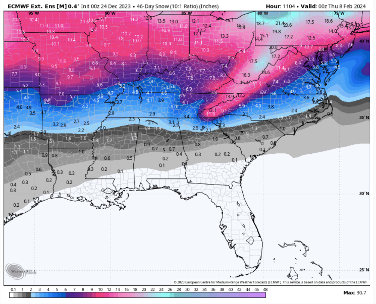
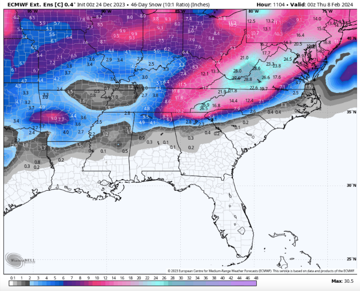
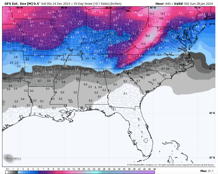
Merry Christmas (Eve....24th run) from your favorite ext global ensembles....2x 46day and 1x35day snow maps. Euro control is picking up on two storms - Jan 12th and Jan 22nd. When snow gets to the Panhandle....usually a good thing on modeling. Modeling definitely is keying on an inland runner Miller A primary track with likely some Miller B thrown in as well. Snow pack to our north means cold air could return in a hurry if the MJO will allow it or the NAO locks. No idea if correct, but enjoy!
Miller B’s are not friendly to us west of 40/81. Seems like we always end up getting dry slotted during the handoff but NE Tennessee and the plateau seems to do well.
.-
3
-
-
Oh yeah, mostly lurking but I’m always around.
I got off for a while, just couldn’t take some of the stuff going on the site. I’m back on as GSM_Vol
.-
2
-
-
18z GFS giving us a dose of nostalgia for Christmas

Glad to see you back. You still on VQ?
. -
General ob in passing as I read today's updates: It sure seems whatever transpires in the short to mid-term pattern-wise will be fluid with a decent ceiling for amplification. I will not speak to any specific system timing; however, it sure seems like there's a better chance of local winter weather mischief as opposed to a grinch-like torchy pattern locking in. The latest weather vids I've watched from DT and BamWx have been encouraging. Even when you talk about MJO progression into mild phases, it seems we have half the primary NA teleconnections cooperating at any given time. Not seeing much evidence to unfavorable stalls anywhere. I'll take it two days into calendar winter.
Could you link those videos please so I can follow their pages? Thanks
. -
2021. The SSW started January 5th and lasted through the 23rd or so. It was an ice box in February but mostly from the Plateau and west. It's the year Texas froze.
2018 was just brutal but it was late winter and we froze in March instead of it happening at a decent time.
There was a weak on in January 2015 as well. We were extremely cold then too.
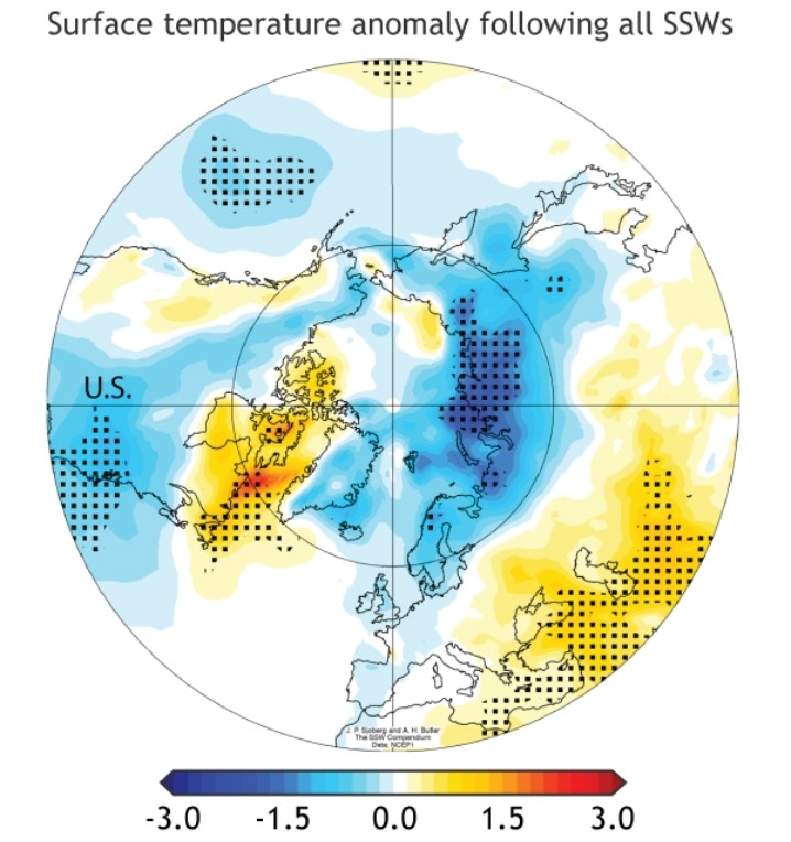
I remember that now. Wasn’t it like 70 in Knoxville with snow and ice in WTn at the same time?
.-
2
-
-
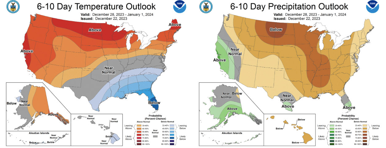
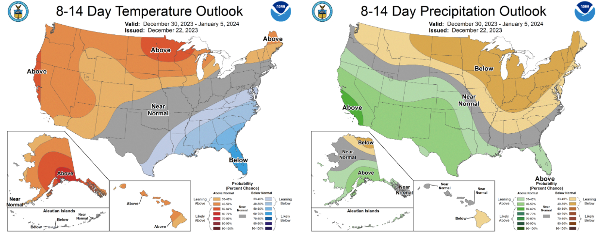
Latest outlooks. Seasonal will work in Jan/Feb. Drought predicted to persist in middle and western areas of the forum north of I-40.
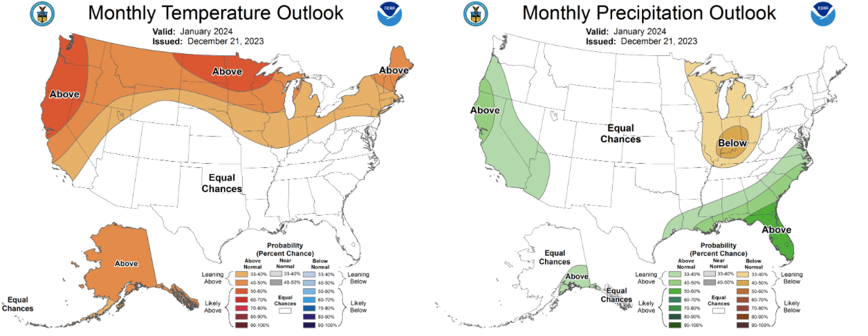
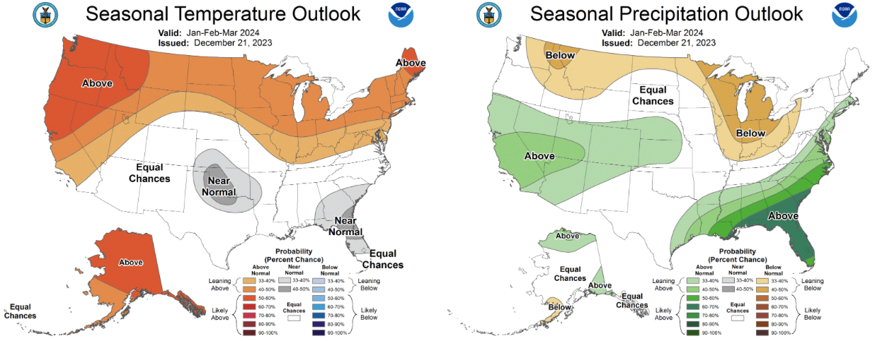
Warmer than average in Alaska gives me positive vibes.
.-
1
-
-
Saw a story a week or so ago that a major strat warming was coming. Hopefully we get the cold and not the other side of the world, if it does split.
When was the last time we landed on the cold side? Seems like it always goes to Europe
.-
1
-
-
Early January 2011 overrunning event. Only time in my life there was a stress free snow. Zero modeling had us getting missed, and temps were in the low 20's when it started. The models had that one keyed in from 7 days out. Even the superstorm was in doubt by many. February 2015 was close to stress free, but not as certain via modeling.
I remember that. Didn’t we have another overrunning event at the first of February? Both had really cold temperatures
.-
1
-
-
Middle to the end of next week is something to watch. This could reach as far north as the Ohio Valley
. -
Funny quote from the MA thread. Someone asked if the volcano in Iceland would help or hurt our snow chances. One response said that molten lava could be a problem.

.-
1
-
-
Was surprised to find a solid dusting at my place in the Colonial Heights area of Kingsport this morning. Nothing on the roads but more white than grass in the area yards. That changed quickly as I drove into Kingsport for work, as most other areas had little or no accumulation on my way into downtown. We must have just caught a good squall at my location. Still, a nice beginning to Christmas week!
Radar last night showed a couple of intense long gated bands track in that area. Seen a couple of tweets of almost whiteout conditions.
.-
1
-
December 2023 Mid/Long Term Pattern Discussion: Let it Snow!
in Tennessee Valley
Posted
Nice burst of snow/sleet in NKnox Co
.