Flatheadsickness
-
Posts
407 -
Joined
-
Last visited
Content Type
Profiles
Blogs
Forums
American Weather
Media Demo
Store
Gallery
Everything posted by Flatheadsickness
-
 Where still on the tale end of yesterdays boundry here . I was at Pinchot with my boy bass fishing about an hour ago I thought it felt eerie. I didn't now tale end Charlie was right next to me.
 -
Looks like another cell trying to rotate just south west heading right at me right now
-
The QLCS should gain forward momentum as the night progresses .
-
By this evening, convective clusters should organize into a broader QLCS that shifts towards the Appalachians. Remnants of this plus further development are anticipated to the lee of the Appalachians from PA to VA tonight, as a secondary vorticity maximum pivots through the base of the amplified shortwave trough. Presence of mid to upper 60s surface dew points and lack of pronounced boundary-layer cooling should yield an environment supportive of bowing lines with embedded supercell structures. These will be capable of damaging wind swaths and a few tornadoes through the early morning
-
My original thinking was LEWP but by the time it gets here it will probably be broken back down to a more cellular mode of storm or some kind of week QLCS
-
Yes Sir. Spc dose expect some weakening east of the Appalachians
-
massive super cell with insane hook just north of Springfiled OH
-
Nice Pic Blizz93
-
The spc expanded the enhanced again to cover the whole state . western pa is probably under the gun the most because of timing. Us and a chunk of OH will be the states to see the worst of it today. Storms will begin rotating in the OH valley in the next hour as the new line develops .
-
ZCZC SPCSWOD48 ALL ACUS48 KWNS 140855 SPC AC 140855 Day 4-8 Convective Outlook NWS Storm Prediction Center Norman OK 0355 AM CDT Sun Apr 14 2019 Valid 171200Z - 221200Z ...DISCUSSION... Models have come into much better agreement through the medium-range period as compared to 24 to 48 hours prior. Both now depict a strong upper trough moving out of the Rockies and into the Plains Day 4 (Wednesday 4-17), eastward into the Mississippi Valley region Day 5 (Thursday 4-18), and then across the Ohio and Tennessee Valleys Day 6(Friday 4-19). This system will be accompanied by an associated/well-developed surface low and frontal system, with the low progged to begin occluding Day 5 over the upper Midwest region. The cold front is currently expected to reach the Appalachians by the end of Day 5 (Friday morning), and then continue eastward to the coast through Saturday morning. Once the front clears the coast, surface high pressure residing over the Gulf of Mexico in the wake of the front and a weaker upper pattern suggests a relative lull in severe potential Days 7-8 (next weekend). Meanwhile however, as the system emerges into the Plains Day 4, strong -- though somewhat meridional -- flow accompanying the system should combine with an amply moist/unstable warm sector to permit storm development, within a zone of ascent focused near the low/front. Though models differ somewhat with respect to the position of the surface low, a somewhat bi-modal risk may evolve -- with one relative maximum near and ahead of the surface low where directional shear should be greatest (currently expected in the vicinity of Iowa), and a second from the southern Plains eastward into the Ozarks/Arklatex where the most substantial CAPE should evolve. Large hail and damaging winds are expected, along with some tornado risk -- especially nearer the surface low/warm front. As widespread convection develops through the overnight hours, and shifts eastward, a more complex forecast becomes apparent due to the effects of the precipitation and associated cloud cover an warm-sector destabilization for Day 5 -- and similarly for Day 6 as the expansive area of convection continues advancing eastward toward the Atlantic Coast. While details with respect to severe risk are therefore difficult to highlight this far in advance, large 15% risk areas will be maintained, given the strength of the upper system which will provide a kinematic field favorable for severe storms atop a warm/moist pre-frontal airmass. ..Goss.. 04/14/2019
-
I just noticed Spc is not messing around with day 4 looks to be a very bad day to have already highlighted such a huge 30% area 4 days out. Another multiple day on the way. Kinda Scary Deja vu 2011.
-
SPC AC 140601 Day 1 Convective Outlook NWS Storm Prediction Center Norman OK 0101 AM CDT Sun Apr 14 2019 Valid 141200Z - 151200Z ...THERE IS AN ENHANCED RISK OF SEVERE THUNDERSTORMS FROM PORTIONS OF THE OHIO VALLEY SOUTHWARD INTO THE SOUTHERN APPALACHIANS... ...SUMMARY... Severe thunderstorms are forecast today in parts of the Ohio Valley southward through the southern Appalachians and northeast Gulf Coast. Severe thunderstorms are possible this evening/tonight east of the Appalachians from the Carolina Piedmont northward into parts of the Mid-Atlantic states. ...Synopsis... Maturing mid-latitude cyclone currently moving across the southern Plains is expected to become more progressive today as it moves northeastward through the middle MS Valley and into the Lower OH Valley. Strong flow aloft accompanying the system will spread eastward ahead of the upper trough, extending from the southeast through the TN Valley at midday and across the Mid-Atlantic states by this evening. Surface cyclone attendant to the upper system is expected to move quickly northeastward as well, moving through the OH valley by midday and through much of the Northeast by the end of the period. Severe threat appears to be in two somewhat discrete regimes, one associated with the ongoing storms across the Southeast within the warm conveyor and the other associated more closely with the surface low and stronger large-scale forcing for ascent accompanying the parent upper trough. ...Eastern AL...GA...SC... A line of thunderstorms will likely be ongoing at the beginning of the period across eastern AL or perhaps as far east as western GA. With the forcing for ascent (both associated with the parent upper trough and surface low) shifting northeastward, the expectation is for much of this convection to be waning, supported predominantly by a moist low-level air mass and modest convergence along the outflow. Even so, vertical shear will remain strong and few of the more persistent storms may be able to produce damaging wind gusts through the late afternoon. ...OH Valley...Central Appalachians...Northern Mid-Atlantic... Temperatures across the lower/middle OH Valley will be cool at the beginning of the period but strong warm advection is expected to result in air mass destabilization across the central OH Valley ahead of the approaching surface low. By mid-afternoon, temperatures are expected to be in the mid 60s with dewpoints in the upper 50s/low 60s. Instability will be somewhat tempered across the middle OH Valley but is still expected to be sufficient for thunderstorm development. Strong low to mid-level flow will contribute to a risk for damaging wind gusts and isolated hail. Warmer temperatures are expected with eastern extent and the general expectation is for storms to gradually strengthen as they move eastward across OH and into WV and PA. The loss of diurnal heating could lead to a short-term weakening of the storms during the early evening but this weakening will likely be compensated by a strengthening low-level jet as well as increased large-scale forcing for ascent. As a result, a modestly organized convective line appears possible as the storms move across the central Appalachians. Damaging wind gusts appear to the primary severe threat. However, a strengthening low-level jet and the resulting vertically veering wind profiles could support a few embedded tornadoes. ..Mosier/Bentley.. 04/14/2019 CLICK TO GET WUUS01 PTSDY1 PRODUCT NOTE: THE NEXT DAY 1 OUTLOOK IS SCHEDULED BY 1300Z CURRENT UTC TIME: 0934Z (5:34AM), RELOAD THIS PAGE TO UPDATE THE TIME
-
Spc just upgraded most of are area and half Of Pa. to Enhanced Risk . Stay Safe and enjoy the show.
-
If you think its bad now this storm amplifies as Mississippi falls to sleep tonight. its also now looking like Day 6 through 8 even more of the country gets in on some action. But first it looks like we could be dealing with some strong cells proceeding a line echo wave pattern sunday night in are area befoe this one is done. ZCZC SPCSWOD48 ALL ACUS48 KWNS 130900 SPC AC 130900 Day 4-8 Convective Outlook NWS Storm Prediction Center Norman OK 0400 AM CDT Sat Apr 13 2019 Valid 161200Z - 211200Z ...DISCUSSION... Medium-range models continue to depict progression of a highly amplified upper trough across the U.S. through the Day 4-8 period. While differences are rather substantial with respect to the initial strength of this trough -- and thus its associated surface reflection -- as it exits the Rockies and moves into the Plains Day 5 (Wednesday 4-17), evolution/progression of the upper system thereafter is reasonably similar as it traverses the central and eastern U.S. through the end of the period. Given the amplitude of the trough, and accompanying/well-developed surface system, a favorably strong wind field will accompany the progression of this system, along with ample northward advection of Gulf moisture. As such, it appears that a kinematic and thermodynamic environment supportive of severe storms (and all modes of severe weather) will exist each day -- and therefore 15% risk areas are being added. Though model differences continue to cast some uncertainty as to location of the daily risk, as well as the magnitude, it appears that any risk Day 4 (Tuesday 4-16) will be limited. Day 5 (Wednesday 4-17) however, as the upper trough advances more fully into the central U.S., risk for severe weather is evident from roughly the Mid-Missouri Valley south across eastern portions of the Plains, and eastward to roughly the Mississippi Valley. Day 6 (Thursday 4-18), the risk should extend from roughly the Mississippi Valley to the Appalachians, and as far north as the Midwest states. Day 7 (Friday 4-19), risk should exist primarily east of the mountains. Finally, by Day 8 (Saturday 4-20), the front will likely be advancing offshore, and thus diminished potential is apparent. ..Goss.. 04/13/2019 CLICK TO GET WUUS48 PTSD48 PRODUCT
-
Still raining here. The toed and frog populations are out of control this year if anyone has noticed. Never in my 40 years have I seen numbers like this in my area . The rain is now causing major issues in the rhizosphere and phyllosphere of are Trees and shrubs in the area. It is becoming very noticeable in the lower and now upper branches of most coniferous and many deciduous are also now sacrificing there lower branches . Its also probably drowning a lot of the periodical Cicadas that the animals and I both love to munch on. There a real treat before they molt . What good pics for the forum
-
If any storm lovers are up yet The super cell south of Rankin just took the right turn and is just south of Big lake Tx . Hail core to the extream. The storms along the warm front appear to be trying to rotate already . It Seams to me to be pretty rapid upscale growth for a slight risk environment not to mention most people in Tx are sleeping if the Spc gets caught with there paints down tonight we may see the first high risk day for quite some time tomorrow.
-
The Outbreak looks to be getting under way . Cells just exploded in east and west Tx. I see the spc only has them under slight risk there tonight.. There was just a beast super cell south of Rankin Tx . A complex looks to be forming around the low and the warm sector looks like a swarm of hornets flying north east. The loop on this one is going to be something to see . I hope the good people of the south get through this one ok. Spc also slightly expanded Sundays outlook Maybe Sunday night could get us in on some sweet action. Like I said a few weeks back its looking to be one of those years . Still waiting to here about the Cycles . Looks like I may have to eat shit on that one but we will see.
-
One last note . I was introduced to the above mentioned by reading and listening to Dr. Greg Forbs in 2006-2012 before the globalist agenda completely permeated the weather channel and everything media and destroyed the Earths Science's in the name of the agenda.
-
Bty good job on the last storm fellows I was thinking rain gear until very early Sunday
-
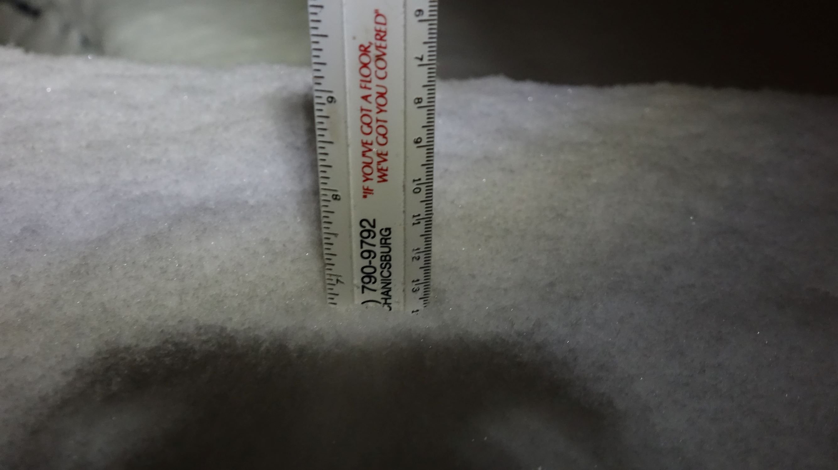
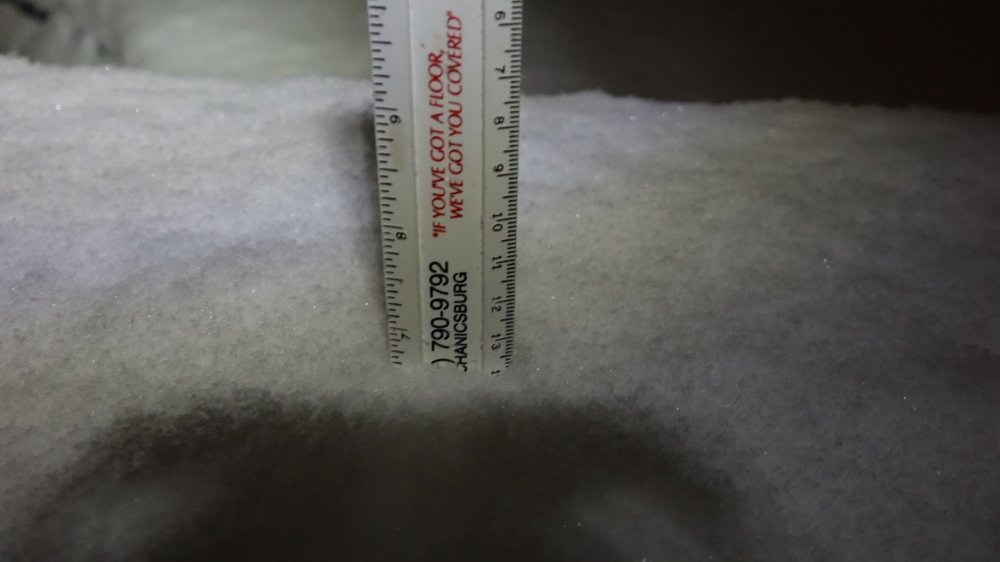
I did very well in all three storms but the last one was to wet for a dog and a camera. So I could not really enjoy the way I would have liked to. Topped out yesterday unofficially around 6.2"
-
Seeing this amped jet, late winter storm tracks and two sever weather outbreaks in two weeks in late winter east of the Mississippi and north of Florida makes me really wish I would have continued to talk about the subject of solar cycles the other day . With every passing storm this late winter I cant help but to be reminded of of late winter /spring 2011 solar activity spike. I believe from what I have noted in the past we may have wrapped up cycle 24's minimum and are now in or very close (a few weeks away) from cycle 25. We should know in a few weeks. I am not saying spring will be like 2011 but I believe it has the potential to look similar . If 2011 where to have a twin it would most likely be the springs of either 2022-2023( The likely maximum peak) if the cycle has even changed. Hell maybe it already has and I'm just uninformed. I have a lot more to say about this and winter storms but I am out of time for today.
-
THANKS GOOD WORK 93
-
Studies in Geophysics The Earths'sElectrical Environment https://books.google.com/books?id=7j4rAAAAYAAJ Not Alex Jones but whether you believe in molecular circumstance , god or the dalai lama this is some great reading on a few subjects I have brought up that were regarded as vodu . I realize its older (1986) but it still stands up well to more recent research on geo physics relationship to weather humans and animals and its free . If you want to learn more I highly recommend the library as a google/internet search will just close the neurotypical mind instantly as intended. As far as Mycoscience as a weather forcasting tool its new, its real and groundbreaking stuff. Most research is being protected by Paul Stamets and his bunch of ass clowns. I would recommend buying some of his books but don't . Don't just be a map hound enlighten educate yourself and have a great day
-
3-2 probably did exceed 3-1 snow fall rates here for a short period . To bad it was not the same ratio here as 3-1. I forgot to clear today. Pic is the last two days
-
Yep good stuff here for about the last hour now. its starting to pivot over eastern pa