

Mshaffer526
-
Posts
196 -
Joined
-
Last visited
Content Type
Profiles
Blogs
Forums
American Weather
Media Demo
Store
Gallery
Posts posted by Mshaffer526
-
-
1 minute ago, NeffsvilleWx said:
Precip is under minimum scan height of radar. Might be able to pick it up from ctp, lwx, dix, or dox.
Lancaster county is in a bit of a radar dark spot. I believe lowest height we can see is 6k or so (don’t quote me on that number).
That's good to know! Thank you.
-
Just passed six inches. Update on that "dry slot"... It has been snowing moderately the whole time despite no radar return whatsoever. Weird.
-
2 minutes ago, AllWeather said:
Closing in on a foot in Manheim, Lanc Co.
and still puking, meteorologically speaking.
That's insane. I am 20 miles ESE of you and I don't have half that. Also just had a dry slot move west into this area that unfortunately looks like it's going to last a while.
-
Just now, paweather said:
Gotta changeover shortly.
Hope springs eternal

-
 1
1
-
-
Steady sleet continues in Gap.
-
1 minute ago, NeffsvilleWx said:
Rule #1: In the LSV, never trust a Miller B (and don't trust the models, either). You're flying blind into a shitstorm, Randers.
+1 for TPB reference.
Steady sleet in eastern LanCo too.
-
I want what the GFS is having.

-
1
-
-
12Z GFS. Still insisting on spreading the wealth across much of the LSV and SEPA.
-
Just now, Jns2183 said:
Radar looks like the lsv will be in the main Ccb for awhile as it forms
.Patience. The system is getting fired up.
-
5 minutes ago, Itstrainingtime said:
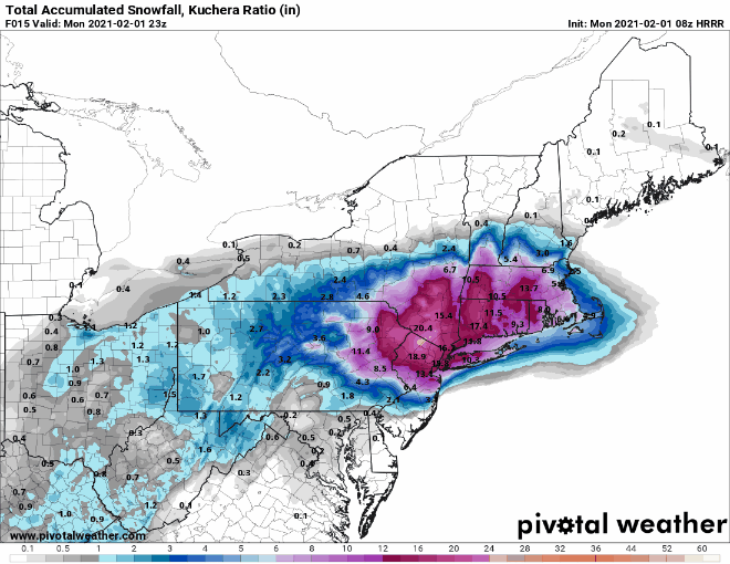
I know it's the HRRR, but latest run depicts 14" in @Mshaffer526 land in Gap, but only 3" in my hood. Brutal cutoff east to west across Lanco.
I would definitely feel better being further east. The RAP has actually come around as well, same brutal cutoff to the west though. This will be very interesting to nowcast.
-
Keep on coming baby.
-
1
-
-
HRRR is actually starting to cave towards the GFS a little bit. Those are the kind of signs we need to see this morning.
-
1
-
-
Last OBS of the night. About 4.2", SN-. Looking forward to the party tomorrow ladies and gents.
-
4.3". I don't smoke, but I suddenly have the overwhelming urge for a cigarette after that NAM run.

-
 2
2
-
-
That NAM shift... My word. I'm going to bed now, gonna need the energy tomorrow night!!
-
1
-
-
-
The NAM caved!
-
It's the NAM vs. every other model, save for the HRRR. I'm cautiously optimistic that we get nuked late afternoon tomorrow
-
31 minutes ago, medmax said:
Is there a coastal SFC low yet?
Big pressure drops off the OBX
-
1
-
-
I'm hugging the GFS all night. Between that and the intense banding on the RGEM tomorrow afternoon that extended the whole way into LanCo, the chips are back in!
-
1
-
-
Two inches down in Gap. Beautiful outside
-
4 minutes ago, CoolHandMike said:
Flakes coming down are kinda chunky, vaguely graupel-ish. I wonder if that's just the way these flakes are growing, because I'm not seeing any kind of warm layer nearby.
Seeing the same thing down here in Gap.
-
1 hour ago, Birdbean said:
State college getting cold feet for us in Lancaster Co?
NEAR TERM /UNTIL 7 PM THIS EVENING/...
10AM/15Z: Initial shot of WAA snow (varying intensity) has
overspread the majority of the CWA as of 10AM. Only minor
adjustments needed to hourly T/Td with maxT still on track.
After seeing the 12Z extended HRRR run, we are growing a little
leary (somewhat less confident) in double-digit snowfall totals
across the Lower Susquehanna Valley. This would be the result of
a longer period wintry mix in the dry slot with the main
deformation band setting up farther to the north. We will
continue to monitor closely.
My bar is 6". Just give us half a foot and I'll be happy.
-
Yup. QPF distribution 20 to 30 miles further east.
.gif.8a8bbb70a65df267ad7cb10d4138832d.gif)
Central PA - Jan 31 to Feb 2 Winter Storm
in Upstate New York/Pennsylvania
Posted
Little under 6" so far. Nice event but what could have been...