
LaGrangewx
-
Posts
399 -
Joined
-
Last visited
Content Type
Profiles
Blogs
Forums
American Weather
Media Demo
Store
Gallery
Posts posted by LaGrangewx
-
-
15 minutes ago, snywx said:
12z NAM..

New RPM is even better than before widespread 20-24. Also Check all the new 12z WRF models lol. They’re quite nice.
-
 I think I hear Windham calling my name Friday.
-
 6
6
-
-
2 minutes ago, Hitman said:
And the central/northern greens. They need it but have a good week of snowmaking temps and then maybe some natural on the backside of the system.
Yup. They haven’t had a big synoptic base building snowfall but they seem to get A lot more frequent refreshers and upslope snowfall than Whiteface or specifically Gore. Gore is in a bit of a tough spot to cash in frequently but great mountain to ski with some great terrain.
-
5 minutes ago, North and West said:
What’s interesting about this is that if you told me last week I would see up to a foot of snow (MMU looks like up to 10, maybe more) a week before Christmas, I’d ask where I could sign up.
Also, a nice economic bump if it does hot NE PA and the Catskills well, since their main revenues outside of season passes are taken at the last week of December. It’s good for that along with a COVID-safe activity.
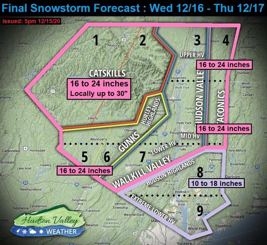
.Yup. That map spreads the love pretty well. Something to note is that last weeks storm crushed New Hampshire into Maine and this storm looks like it should hit the Poconos, Catskills, Berkshire’s and southern Vermont. Gore, whiteface and The poor Adirondacks seem to be the last areas without a good storm so far this winter. Hopefully they get in on the action soon to jump start their seasons, at least some upcoming cold weather will help for man made snow.
-
1
-
-
 Latest RPM looks incredible for entire Hudson Valley. I’m glad this should hit the Some of the ski areas hard. They really need it to get the season going.
-
3
-
-
20 minutes ago, White Gorilla said:
Can't believe we actually have a sleet, mix risk that could cut totals when just yesterday, worried about fringe.
Optimistic right now that we can avoid that. I think you said this seems like A March 2017 Setup. We could be right above the mix line hopefully
-
1
-
-
Lee Goldberg just had 18+ on his map above I-84.
-
1
-
-
4 minutes ago, nesussxwx said:
HI-RES models are seeing a latter-minute amplification trend with stronger mid-level forcing which is pushing the cyclone further north. The mesoscale models would definitely be better at sniffing this out so I wouldn't ignore them, however it is still a bit early for the mesoscale models, later tonight will be more telling.
Globals would struggle to pick up that kind of trend.
Cool. I appreciate the explanation. Hope everyone sees a good storm, been awhile.
-
1
-
-
Just Looking at the maps with a limited meteorological background, seems to me like the GFS and EURO for our area are very much in agreement now with their latest runs. Hi-Res and short range want to push the best goods even farther north but still would be a great storm regardless. I’m excited to get some snow and start this winter off with a bang.
-
1
-
-
It will be interesting today and Early tomorrow to see if the models continue a Northerly trend or if they’ve reached a peak and begin to inch back south a bit.
-
23 minutes ago, White Gorilla said:
12-18 looks about right for our interior areas with pops at 24 over the Cats or where banding sets up. This feels like March 2017.
Agreed. Got clobbered here with just under 2 feet but the absolute best banding actually set up Around lake placid all the way into the Adirondacks had 40+.
-
1
-
-
7 minutes ago, IrishRob17 said:
It did make quite the jump, it took long enough!
What a terrible job that model did the last few days. I believe Saturday 18z it had the monster and then lost it.
-
Crazy how 24hrs ago there was a real fear of suppression with this system. Knock on wood but that ship seems to have sailed at this point.
-
1
-
 1
1
-
-
Wow amazing 0z suite for our region.
-
I’d be lying if I said I wasn’t excited with tonight’s runs. Now the ukmet and cmc way north.
-
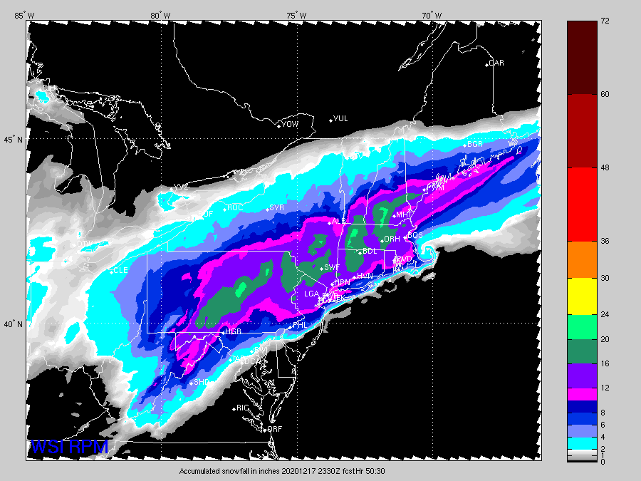
One thing to keep in mind is the rgem specifically and the NAM to a degree are picking up on a very intense band. Initially the rgem had that band south but now 2 runs in a row it has cut right through orange and dutchess. Will be interesting to see how this continues to play out with modeling and then of course plays out with the event. The 40” totals are obviously overblown but in those bands 20+ maybe 24? Where ever that banding reaches up to, just north of it will probably have a pretty extreme cut off.
-
Welp we are 1-1 on 0z suite with that NAM run. Let’s keep it going!
-
Rgem continues a nice NW trend keep it coming lol. Crushed for the suburbs. But only a 12 hour storm. Tough to get more than 18” maybe someone cracks 20+ in the best banding
-
1
-
-
Wish we could lock that Nam run in lol. Nice 18-24. Can Only go downhill from here
-
3
-
-
3 minutes ago, IrishRob17 said:
2.7" for me in that disatah.
Speaking of which. February 2010 was also disaster for me. I got maybe 6-10” of mix slop flipping back and forth while 15 miles right across the river got 30+ lol
-
Looking at records hoping this storm has more of a 1996 or 2003 cutoff up near I-90 instead of 84. Seems the cutoff for these bigger storms has went south some over the years. I’ve had a lot of ~12” type storms but the true biggies are few and far between
-
7 minutes ago, IrishRob17 said:
I just looked that up in my records, .4" for me, storm total.
Yup 0 for me I believe and 6” in southern dutchess and then 30” in NYC lol. Absolutely brutal. There’s been other fringes I remember too like January 2014 I believe. I-84 has been a cutoff to a degree and the taconic mountains could potentially have something to do with it. East west fringe has also happened a bit. Feb 2013 I had 12-13 but across the CT border had 30 and then in 2015 one of the most epic busts I had 6“ and New England got crushed. I believe I’ve only had 3 18+ in the last 10 years And they are December 2010, February 2014 and March 2017. Bottom line from my experience Dutchess is in a tough spot to jackpot coastal Storms inmo we are usually either slightly Too far west or north.
-
3 minutes ago, IrishRob17 said:
That said...I've personally experienced some painful extreme cutoffs in recent times.
Agreed. Would be a shame if this trended that way as we get closer. Would you start taking a better look at Short range guidance starting tonight? I expect The NAM will most likely sink south some with every coming run
-
8 minutes ago, snywx said:
There is gonna be a weenie band setting up shop somewhere between 80 & 84. Someone in there is prob in line for 15-20”. I think everyone else up here is good for a nice 8-14” snowfall. I do think the immediate coast taints for a bit.
Agreed I think a Fairly widespread foot give or take a few. Blend of Modeling seems to be picking up on that axis you mentioned and also heading into northern Westchester county looks great for a bit extra.

Interior NW & NE Burbs 2020
in New York City Metro
Posted