dj3
-
Posts
634 -
Joined
-
Last visited
Content Type
Profiles
Blogs
Forums
American Weather
Media Demo
Store
Gallery
Everything posted by dj3
-

Western Pa / Pittsburgh area Winter Discussion ❄️☃️
dj3 replied to north pgh's topic in Upstate New York/Pennsylvania
Yep, at least it would be a pack maintainer since we avoid plain rain. Also it looks like its loading up a storm for the 16th-17th like the Euro -
Western Pa / Pittsburgh area Winter Discussion ❄️☃️
dj3 replied to north pgh's topic in Upstate New York/Pennsylvania
GFS looks like it made a move toward the European on the weekend event. Gives a colder outcome but the system looks more disorganized. -
Western Pa / Pittsburgh area Winter Discussion ❄️☃️
dj3 replied to north pgh's topic in Upstate New York/Pennsylvania
Yep, I was surprised how much we had when I woke up this morning. I think we must have been under a nice band for quite a while last night. My sister lives more north towards freeport and didn't measure quite as much. -
Western Pa / Pittsburgh area Winter Discussion ❄️☃️
dj3 replied to north pgh's topic in Upstate New York/Pennsylvania
I agree, the Wednesday night into Thursday wave looks like it has trended south. I have noticed that the euro and gfs are developing snow again into the region again late Thursday night into Friday, almost like it has separated into 3 smaller separate waves now. Something to keep an eye on and nice to not be sweating any p-type concerns. -
Western Pa / Pittsburgh area Winter Discussion ❄️☃️
dj3 replied to north pgh's topic in Upstate New York/Pennsylvania
The Nam has a really narrow max precip band and you couldn't draw it up more perfect for Allegheny County. With cold temperatures and most of this falling overnight I wonder if this overperforms. -
Western Pa / Pittsburgh area Winter Discussion ❄️☃️
dj3 replied to north pgh's topic in Upstate New York/Pennsylvania
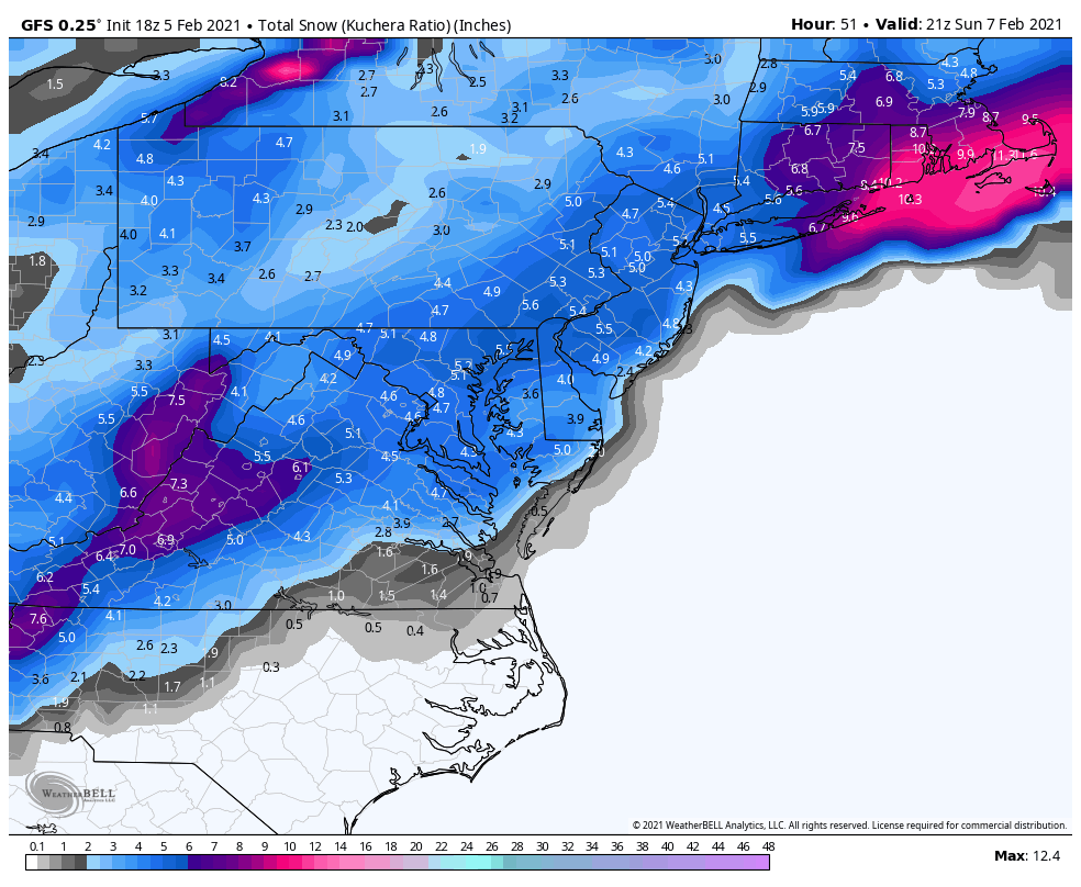
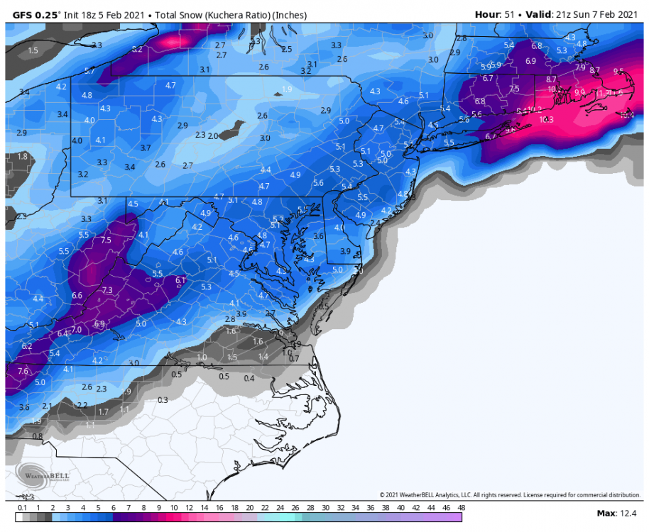
The Euro keys on a different wave than the GFS and develops a more significant coastal early next week instead of Sunday. Don't recall seeing that shade of pink over us before for snow haha. -
Western Pa / Pittsburgh area Winter Discussion ❄️☃️
dj3 replied to north pgh's topic in Upstate New York/Pennsylvania
-
Western Pa / Pittsburgh area Winter Discussion ❄️☃️
dj3 replied to north pgh's topic in Upstate New York/Pennsylvania
Looks like a wintry week setting up. Will be interesting to see if we can get better than 10:1 ratios with either of the waves this week. -
Western Pa / Pittsburgh area Winter Discussion ❄️☃️
dj3 replied to north pgh's topic in Upstate New York/Pennsylvania
-
Western Pa / Pittsburgh area Winter Discussion ❄️☃️
dj3 replied to north pgh's topic in Upstate New York/Pennsylvania
Looks to be a quick mover but I would take any snow to refresh what gets washed away later tonight. -
Western Pa / Pittsburgh area Winter Discussion ❄️☃️
dj3 replied to north pgh's topic in Upstate New York/Pennsylvania
Looks like there is potential for something bigger from around Feb 12-15th time frame. -
Western Pa / Pittsburgh area Winter Discussion ❄️☃️
dj3 replied to north pgh's topic in Upstate New York/Pennsylvania
Trend is our friend? -
Western Pa / Pittsburgh area Winter Discussion ❄️☃️
dj3 replied to north pgh's topic in Upstate New York/Pennsylvania
Don't forget the ICON model which gives us the MOST snow for Sunday. -
Western Pa / Pittsburgh area Winter Discussion ❄️☃️
dj3 replied to north pgh's topic in Upstate New York/Pennsylvania
Definitely. The next 2 weeks look to be plenty cold and active. -
Western Pa / Pittsburgh area Winter Discussion ❄️☃️
dj3 replied to north pgh's topic in Upstate New York/Pennsylvania
Looks like the trend for Sunday is less phasing and more late blooming coastal. Either way it looks frigid for Sunday night-Monday. -
Western Pa / Pittsburgh area Winter Discussion ❄️☃️
dj3 replied to north pgh's topic in Upstate New York/Pennsylvania
That snow map is absurd. Definitely some potential in the next 10 days. -
Western Pa / Pittsburgh area Winter Discussion ❄️☃️
dj3 replied to north pgh's topic in Upstate New York/Pennsylvania
-
Western Pa / Pittsburgh area Winter Discussion ❄️☃️
dj3 replied to north pgh's topic in Upstate New York/Pennsylvania
Route 28 and the parkway were mostly slush/wet when I went through this morning. I wonder if so many people working from home and a lighter rush hour makes it easier to treat the roads. My niece is 7 and they had a remote learning day today due to the snow. Kind of interesting to think maybe true snow days for school are no more? -
Western Pa / Pittsburgh area Winter Discussion ❄️☃️
dj3 replied to north pgh's topic in Upstate New York/Pennsylvania
Amazing how muted the cutter signal has become for late week and now we have a legit storm window once the front moves through on most guidance. Block finally producing? -
Western Pa / Pittsburgh area Winter Discussion ❄️☃️
dj3 replied to north pgh's topic in Upstate New York/Pennsylvania
Euro also says let’s run it back for the super bowl next Sunday holy cow -
Western Pa / Pittsburgh area Winter Discussion ❄️☃️
dj3 replied to north pgh's topic in Upstate New York/Pennsylvania
Yea back to very light here as well. Maybe another hour or two before we get back into some good bands. -
Western Pa / Pittsburgh area Winter Discussion ❄️☃️
dj3 replied to north pgh's topic in Upstate New York/Pennsylvania
All good man. Feels like we’re always walking a fine line so I get your concerns. Snow picking back up now, I think we’re in for a good afternoon and evening. -
Central PA - Jan 31 to Feb 2 Winter Storm
dj3 replied to MAG5035's topic in Upstate New York/Pennsylvania
Good luck with this one MAG, hope you get crushed. Appreciate you always including us western pa folk in your analysis and now the storm thread. -
Western Pa / Pittsburgh area Winter Discussion ❄️☃️
dj3 replied to north pgh's topic in Upstate New York/Pennsylvania
I’m just happy snow is gonna be flying most of the day. It will stick especially as we move towards late afternoon and evening. -
Western Pa / Pittsburgh area Winter Discussion ❄️☃️
dj3 replied to north pgh's topic in Upstate New York/Pennsylvania
The heavier returns in Ohio are eventually going to rotate through southern pa. Not sure if we are going to get a lull before that happens or if the current band moving through will back fill a bit. Around a half inch here so far