

Hoosier
-
Posts
47,183 -
Joined
Content Type
Profiles
Blogs
Forums
American Weather
Media Demo
Store
Gallery
Posts posted by Hoosier
-
-
1 minute ago, Chicago Storm said:
ORD up to a storm snowfall total of 3.5”
.The 9.8" big dog futility record is about to officially stand for another year.
-
25 minutes ago, Chicago WX said:
You can’t find the website?

But of course, ratios are much lower now. Still, point stands…overnight snows were greater than 10:1.
Didn't have time to look then. Had seen some LSRs with snow amounts but not liquid equivalent.
-
17 minutes ago, Chicago WX said:
Smells like a I-88 to MSN special, or somewhere in that corridor. These always have a late north trend it seems.
Anecdotally I'd agree that the heavily fgen driven setups seem to drift north in closing time more often than drifting south. Don't know why.
-
4 hours ago, Chicago WX said:
Looking at CoCoRaHS reports so far, the 10:1 or less crowd is taking a beating.

What are some ratio reports so far?
Whatever they are, I would suspect a lowering trend now (especially outside of the primary heavy banding) as temps nudge up. It's snowing here but not really accumulating at this point.
-
4 hours ago, chuckster2012 said:
Just talked to my brother. Says Cincy got 7" Sunday. Up to 16" now for season.
Would make for an interesting project to see how many times Cincinnati has beaten Chicago in snowfall for a season. Not gonna happen often of course. I'd bet it happened in 2002-03 but maybe not since then.
I do think ORD may be able to rally enough to top Cincinnati in the end though. Just a hunch.
-
 1
1
-
-
11 minutes ago, SchaumburgStormer said:
LOT popping the advisory for the whole area. Seems like overkill for areas north of I-80
They are hitting on Alek's secondary band idea in the afd.
Definitely concerned about ending up in the minima zone here, with heavier amounts south and also somewhat heavier amounts north. Various guidance tries to smooth it over around here via lake contribution, but temps may be a bit too mild by then and result in junk snow. Guess we'll see.
-
27 minutes ago, Chicago WX said:
Rain?
But, seems LAF is right on the line or close to it, on several models for a good hit. Hope it happens. And for our other Indiana people too.I like the 6" mark or so for LAF. Maybe a tad more.
Would go with the heaviest JUST n/w of Indy, but it's very close and certainly within the realm of possibility that they end up in the heaviest band. But I think I'd rather be out toward Zionsville or Lebanon.
-
3 hours ago, Chicago WX said:
Looks like the 6z Euro bumped a little north. Been watching that STL to LAF to FWA area on the models. Think that corridor may be the jack zone.
I wonder what Chad is saying...
-
At least temps won't be a mitigating factor where it snows.
-
9 minutes ago, RCNYILWX said:
Yep have been noting that on other guidance too. The Euro as you noted had kind of lost that look for a few cycles. It's going to snow over a large area due to that northern stream influence vs. the classic sharp cutoff northwest. Pretty interesting forecast in that the heaviest banding will be tucked in atypically close to the surface low while the lighter accumulating snows will expand well north and west.
Also tricky from a headline perspective because I think the snow falling Wednesday beyond mid-late morning will be pretty low impact due to the temps at or above freezing. I think we're probably starting out with an advisory for the I-80 and south counties and then the day shift can make adjustments northward if needed.
Some of the metro counties and into Chicago are a tougher call. The initial snow could come down at a decent clip, so if confidence grows in impacts to the commute, we may need an advisory for at least up to central Cook zone and probably DuPage.
Sent from my SM-G998U using Tapatalk
The Cook/Lake IN area has been the most interesting for me as to what your office will decide to do from a headline perspective. There's an added complication for Cook though in that even if rates are decent initially, temps may be just above freezing especially closer to the lake, thus calling into question how bad the road conditions would actually be for the commute.
-
1
-
-
1 hour ago, RCNYILWX said:
I think another issue with this system is it's very compact. That sfc low track is normally good for much of the Chicago metro, but the 850 mb and 700 mb lows are tucked in closer to the surface low than typically occurs.
Sent from my SM-G998U using Tapatalk
Solid observation. Not the best tilting with this system.
We've had surface lows way down in southern/eastern Kentucky that produced good snows into the southern metro (2/13/07 is one example). Can probably find even more dramatic examples than that in storms w/a good inverted trough extending well north.
-
1
-
-
38 minutes ago, Chicago WX said:
I’m thinking 2-4” in my hood. I know that’s wild and crazy thinking!
But, I think the southeast 1/3 of LOT’s CWA warrants an advisory.
We're actually pretty similar in thinking.
-
19 minutes ago, Chicago WX said:
Maybe they’ll just forecast white rain. No accumulations for anyone!

It's odd when I'm the more tempered one.

At this point, just don't see a compelling case for an advisory for at least the northwest half and more like 2/3 of the LOT cwa. But we'll see if things can trend better across the guidance suite.
-
27 minutes ago, sbnwx85 said:
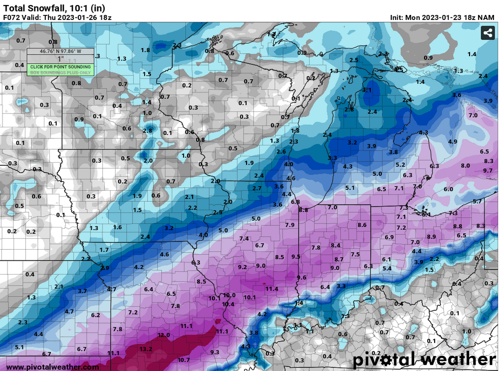
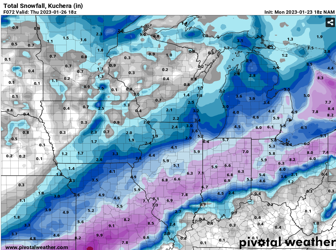
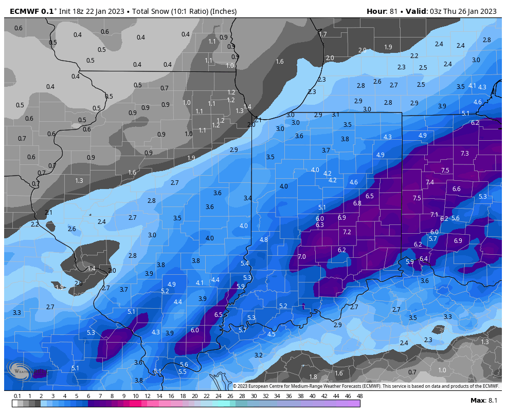
Kurchera vs. 10:1. Pick your fighter.
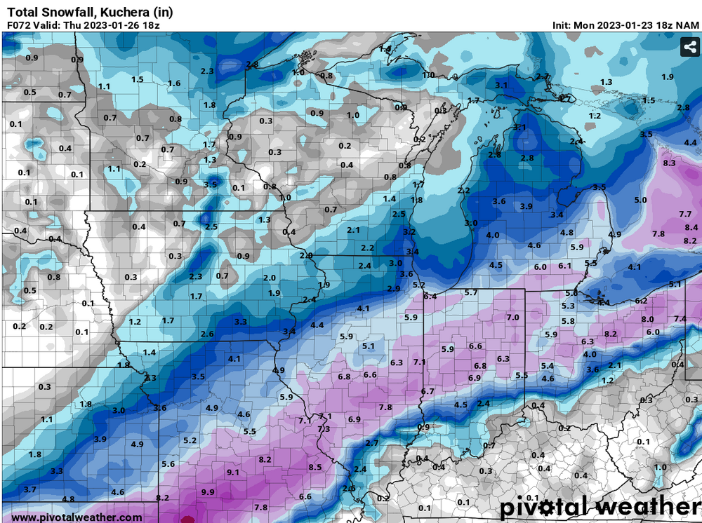
Now post the snow depth map from pivotal.
-
 2
2
-
-
58 minutes ago, TheClimateChanger said:
That's like February 1998. I was shocked to learn there was a storm early that month that dumped 18.5 inches at Cincinnati - at least at the airport in northern Kentucky, and 20-24" from Louisville to Lexington and even into southern West Virginia. Beckley had two 26" storms within two weeks - one in later January and then one in early February.
I guess it's kind of like that. But from an anomaly perspective, this January is currently way warmer than Feb 1998. Even the mean temps so far this month are running warmer than Feb 1998 in the southern sub (will have to see what they are at month's end), which is impressive given that January is a calendar month earlier than February.
-
If I were LOT, I don't know if I'd even bother issuing an advisory in most of the cwa. Total amounts may make it into advisory criteria in some areas, but magnitude of road impacts are questionable overall. And for Chicago metro, precip onset doesn't look to be until around the start of rush hour Wednesday morning, so not like there will be ample opportunity for conditions to go to shit prior to the commute.
The best argument for an advisory may be the ridiculous lack of snow so far this winter, lol
-
A lot will depend on the weekend system. If that doesn't really pan out, then very few areas would pull it off.
-
Given the look over the coming days, we could be on the way to having a pretty freaky January in parts of the sub. It is quite conceivable that some areas will receive near average or even above average snowfall for January, despite it being a top 5 or 10 warmest January. And I'm not talking about just the northern tier, where it's easier to pull off the combination of very mild and snowy. I'm talking about parts of the central and southern sub.
-
Reluctant to really go above 3" here due to the temp concerns. I think the lake enhancement could be reaponsible for up to 1" or so, so the areas near the lake around Chicagoland and into northwest IN may come in with somewhat better amounts than areas farther west in LOT.
-
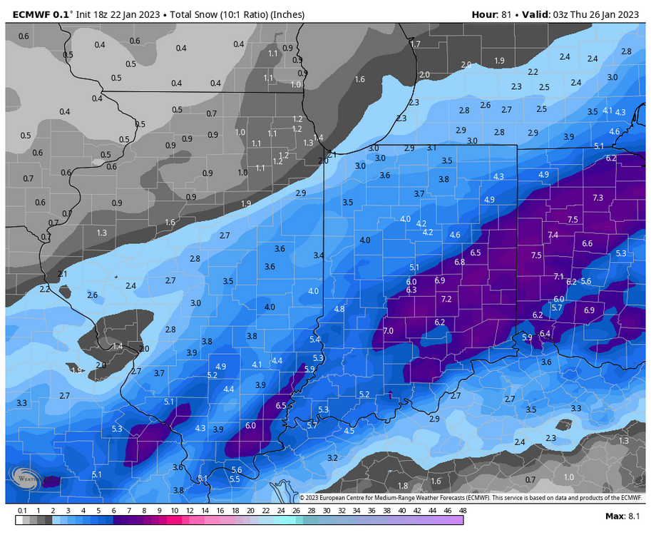
Wonder if Michigan may be able to do slightly better with ratios. Progged to be just a touch cooler in most of that state with the exception of the southeast corner. So Josh may struggle a bit more with ratios than the areas nw of there.
-
58 minutes ago, tuanis said:
These marginal temps are a buzzkill. This system for the most part looks like a drippy slopfest. This thing would deliver if we had some cold air involved (the weekend potential has the goods to tap into... here's to hoping it materializes).
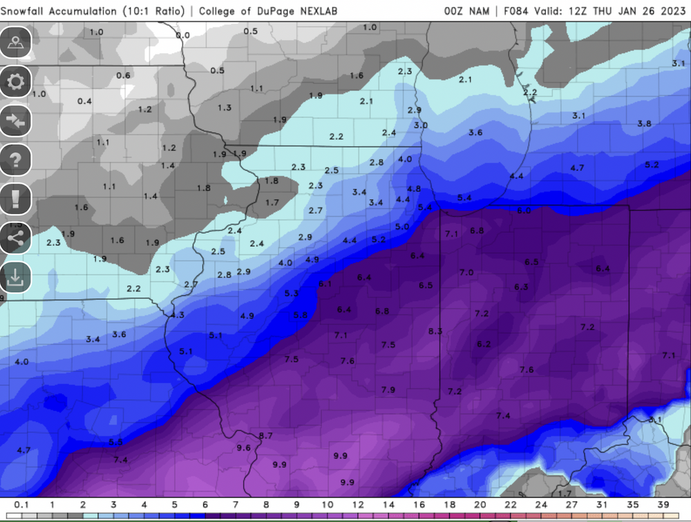
LOT actually mentioned ratios of 10-13:1. I could see that during times of heavier rates/banding, but not sure as an event average (especially that higher end). I'll consider it a win if we end up at 10:1
-
1 hour ago, Chicago WX said:
0z NAM bumping north. Warning snows to southern Cook over to Hoosier.
Would be nice, but have concerns about garbage snow/inefficient accumulation during Wednesday afternoon. Of course the way around that would be 1) earlier timing for the bulk of the snow or 2) heavier rates during Wednesday afternoon
-
1
-
-
32 minutes ago, METALSTORM said:
Got a WSW from LSX for the I-44 corridor and south. SGF and PAH in on the action too.
This should be a pretty good storm for those areas... relative to their climo.
-
2
-
-
1 minute ago, mimillman said:
Oof


Midwest/Ohio Valley/Great Lakes Snow January 24-26
in Lakes/Ohio Valley
Posted
I was wondering about amounts around there. Saw that IND just reported a snow depth of 2" but wasn't sure how much actually fell. 0.67" precip so far.