

StormchaserChuck!
-
Posts
2,273 -
Joined
-
Last visited
Content Type
Profiles
Blogs
Forums
American Weather
Media Demo
Store
Gallery
Posts posted by StormchaserChuck!
-
-
I have to wonder if we can dig a NE trough in here this Winter (like 12-13, 13-14) if we have this kind of rainfall pattern setting up.

-
Kind of encouraged by this bubble -EPO in the next few days, it proves I think that Alaska could be a vortex for anomaly this Winter, positive or negative
-
I was surprised by this La Nina, look at the Nina-RNA developing.
http://mp1.met.psu.edu/~fxg1/ENSHGTAVGNH_6z/ensloopmref.html
-
No way the La Nina lasts into next year, I can already see its waning subsurface structure.
-
Looks like a healthy La Nina.. watch that warm water to the West for the Spring.
-
We are far away from an organic environment at this point.. you can make the case that global warming is a secondary product of that.
-
I was thinking raindance knows some good relevant Winter correlations to major snowfall early this far south.. it's been a great localization experience.
-
I haven't looked, but I think it comes in around -0.60 for Dec-Mar......... I think it will bust.
-
Oct -NAO to Nov +NAO is +NAO for the Winter 60% of the time.
-
 1
1
-
-
-
I just don't see signs for a SE-ridge. That would mean the pattern is more than weak.
-
I would say the NAO difference is within random error range.
-
Never seen 75% on the CPC's 3-month Winter before. (edit: that was before). Weak-weather.gov continues to play behind on the most basic weather-observation sense.. I doubt the NW will verify this Winter.
-
meh, I'm not really impressed by this
-
It actually warmed up significantly to positive
-
6 hours ago, raindancewx said:
I'm not sure that the lack of relationship since 1990 is a climate change thing though - I think it could conceivably revert back. But the Typhoon Tip guy had asked about if it changed in more recent years. I don't use October to try to predict the NAO. I've had much better success using the change from April to May and March to September as a blend to predict the NAO in winter. March to September is probably indirectly an indicator of the total sea ice extent change, and April to May is just a decent indicator for whatever reason. I'm pretty sure there is academic literature supporting May as a predictive period for the NAO though, I think that's where I got that part of it.
I found a better correlation to May-Sept SSTs in the NOrth Atlantic, vs actual NAO. It was like 0.75 vs 0.58. It hasn't worked the last Winter though so...
-
2 weeks from now is different from now, arctic sea ice extent pattern. That one doesn't get to 100dm anywhere anyway.
-
Jet stream is just too far north. It would take a miracle.
-
I feel like it's all digital snow at this point-what's that 2 years since 11/15/18 with like 5" of snow (0" last Winter)?
-
Intuitively, the modeled strengthening Nina doesn't correlate to other things. We'll see, I guess. Even if the Nina strengthens, my guess is there will be lack of -PNA-strong, or PNA descending.
-
I really hate the setup, October NAO is inversely correlated to the Winter. Then we have a 3-part ridge over the Arctic circle and northern gulf of alaska too. Ugly imo.
-
What do you think about Western drought and Washington drought compared to this year?
-
A pretty nice October. temperate.
-
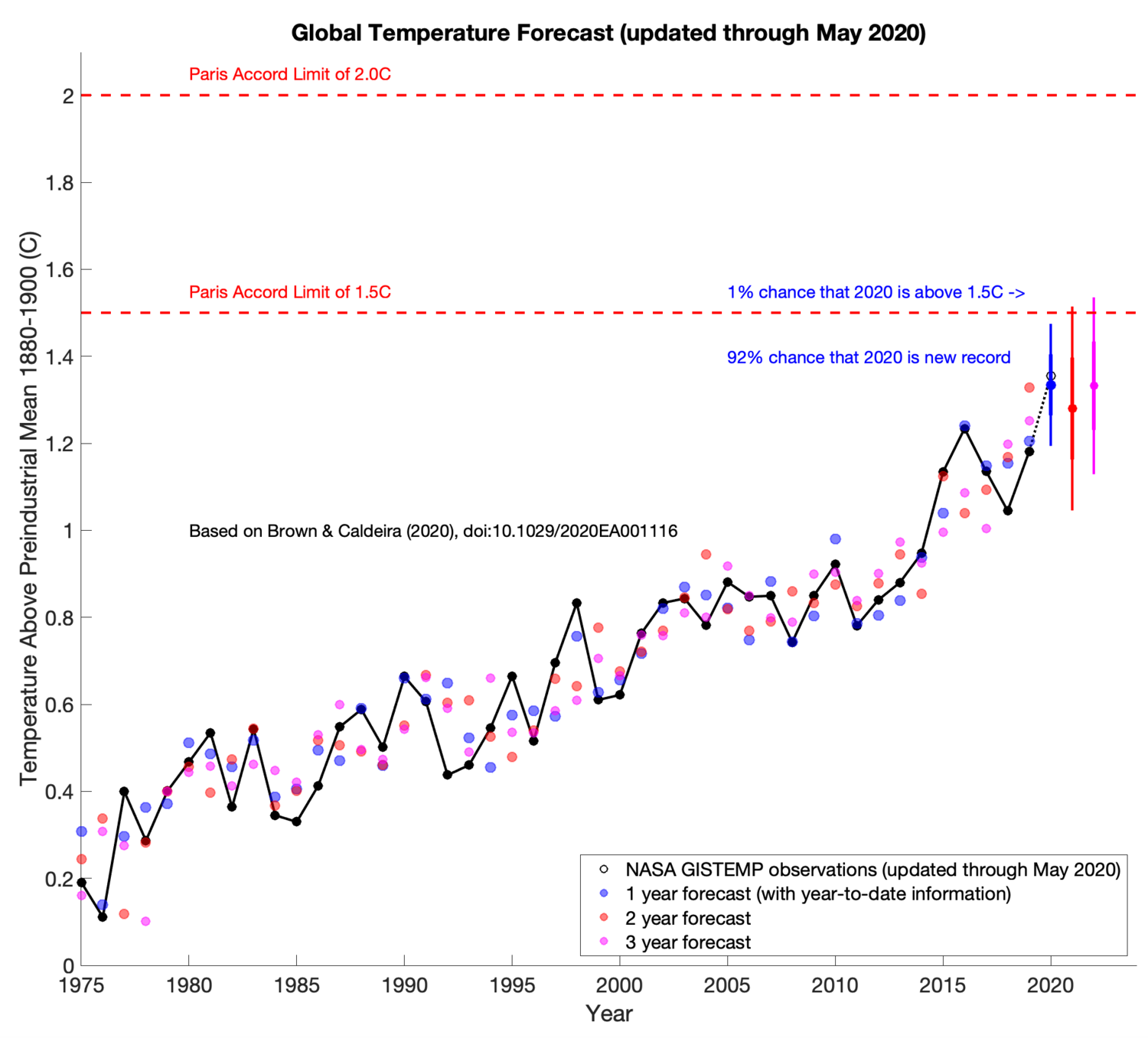
On 6/17/2020 at 5:38 AM, chubbs said:
Near-term forecast of global temperatures based on surface temperature patterns i.e. ENSO, PDO etc. Dots show how method has performed. Website will be updated monthly - site has links to a paper describing method.
https://www.weatherclimatehumansystems.org/global-temperature-forecast

Nope. Enjoy your government.

Winter 2020-21 Discussion
in Mid Atlantic
Posted
Going to be tough with La Nina dominating many parts of pattern right now. QBO is unfavorable too, I think. (Something to watch is Nov-Dec '18 and '19 had the coldest Stratosphere ever for that time of the year going back to 1948. Should be interesting to see if '20 does it. And maybe '21 too.)