MazooWeather
-
Posts
3,866 -
Joined
-
Last visited
Content Type
Profiles
Blogs
Forums
American Weather
Media Demo
Store
Gallery
Everything posted by MazooWeather
-
Moved today, new name and everything.
-
Looks like it just barely missed the afb but many structures nearby are destroyed
-
SPC is in backup mode today
-
Incredibly rare phenomenon here right now, quick burst of snow despite it being 47 degrees outside
-
A moderate risk for tornadoes 100% would have verified today, every storm in that area is spinning up something right now
-
End of an era
-
Chased the tornado warning here locally, it tried to produce one, had a very brief funnel cloud just outside of reading but in the time to open my camera app it petered out in between lightning strikes.
-
Airport reporting 80 mph gusts, also nasty looking tornado on the ground near Carson City
-
Line is starting move ESE it looks like on radar so you might just get the tail end
-
SPC holds at enhanced due to uncertainty
-
Morning rain is dying off fast, has a feeling it's gonna be one of those days
-
Enhanced risk expanded further east towards Detroit for wind and tornadoes ahead of the line while a cig 2 tornado risk has been introduced further west
-
Mammatus clouds in the wake of a decaying severe thunderstorm here, hearing that pretty much everyone in seeing them tonight
-
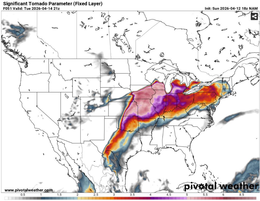
Nam things

-
Tuesday looking like it could be a fun day for most of us
-
You called first dibs so I shall make it so.
-
Might be moving to Kalamazoo in the next month, gonna have to change my name if I do lol
-
Hoping the cap holds tonight so we can get a better TOR threat tomorrow, SPC and IWX are thinking sig tors are possible if there's not a ton of morning crapvection
-
Enhanced risk introduced
-
Being in the warm sector this time locally really sucked, got a severe warning but the winds stayed subsevere
-
Just lost power with power lines down all over the county from a massive gust a few minutes ago
-
That 18Z NAM Solution would have southern MI immediately go from 60s with damaging winds to heavy freezing rain behind the line, brutal
-
Rotation starting in the line in Calhoun and St Joseph County MI
-
Lots of run to run variability with this one, small shifts will be the difference between rain, ice and snow for peeps in Northern Illinois and Southern MI
-
Line looks to be slowly strengthening as it crosses Lake Michigan