

dwagner88
-
Posts
1,096 -
Joined
-
Last visited
Content Type
Profiles
Blogs
Forums
American Weather
Media Demo
Store
Gallery
Posts posted by dwagner88
-
-
Horrible winter here. Less than an inch of sleet was my seasonal total. I missed a 6" snow event by about 20 miles.
-
 3
3
-
-
60 and sunny in Chattanooga, 32 and snowing in Wise. That’s a long ways from here but still a huge difference in temperature.
-
2
-
-
1 hour ago, Holston_River_Rambler said:
seriously though:

I’m still skeptical. It was supposed to rain all day yesterday and all night last night. So far just a trace here.
-
1
-
-
Very odd movement of precipitation from SE to NW today. That's pretty rare.
-
1
-
-
13 hours ago, PowellVolz said:
My friend in Cleveland Tn got around 2-3”. Less than that as you go towards Chattanooga
.I got nailed in that one. Over 10" of wet concrete. Even the airport got about 8". Downtown got less due to mixing.
-
2
-
-
MRX messed up their event report for this. Officially KCHA got 1.7". MRX's report states that this is the most January snowfall for KCHA since 1996. They seem to have forgotten about the January 2011 snowstorm that brought nearly 8" to KCHA overnight. 1.7" being the largest event in 28 years is really sad. Even for here.
-
1
-
-
19 minutes ago, Carvers Gap said:
But truly, I am just glad not to be running in sub 10F wind chill right now. A week or two break is fine with me!
I haven't run outside since before Christmas. I've done almost 100 miles on a treadmill since then. I'm finally going to fix that this weekend.
-
3
-
-
The WAA is shocking. Started out at 11.8 degrees this morning. Already pushing 40 in just a few hours.
-
4
-
-
Strangely, my low temp last night was identical to my coldest temp in the arctic blast last year after Christmas. 5.4 degrees. Maybe that's the limit without snow cover around here.
-
2
-
-
Just now, Jed33 said:
Good to know about the calcium! I didn’t know that was used.
We don't use it very often because it is both extremely expensive and extremely corrosive.
-
4
-
-
15 minutes ago, PowellVolz said:
How cold will the melting agents work down to? My 4 lanes around here have standing water on them and they are all wet. Seems like that’s going to be a problem when the sun starts to set.
.The calcium is good to around zero. That's what we've been using up there all day. Salt and brine are already worthless at current temps. We are trying to get a lane cleared in each direction before the sun goes down.
-
4
-
 1
1
-
-
25 minutes ago, Knoxtron said:

Guess I'm stuck lol
I'm working on it. Just sent a grader and two trucks with liquid calcium chloride up there.
-
4
-
-
Just went on a long drive out to the Rhea/Roane county line. Spring City might get a foot. They had over 6" when I left and it was snowing about as hard as I have ever seen. I parked my truck for 20 minutes and got just under 2" on the mirrors and the toolbox.
-
3
-
-
2 minutes ago, Tucker1027 said:
Where are you located?
.Right next to Apison elementary. It’s actually picked back up now. I would call it moderate. Maybe the column has cooled enough to get rid of some of the sleet.
-
7 minutes ago, Uncle Nasty said:
It's been puking in Ooltewah for a little while now. It looks like the rain snow line is a hair to our south. Is it possible for us to stay all snow in the transition zone and overperform?
I know it's a computer generated forecast, but TWC took us from 1-3" to 5-8" right after the moderate snow started.
I'll take half that amount and call it a day down here!
Sent from my SM-S916U using Tapatalk
I think the transition is in between you and me. I had nice flakes 20 minutes ago, now mostly sleet again. Shame too. The radar actually looks amazing.
-
2
-
-
I actually don’t think Chattanooga is going to get screwed. The entire area except eastern Polk has wetbulbed below freezing. There appears to be no mechanism to allow for warming today with precipitation falling, solid cloud cover, and continued push south of Arctic air. We are going to get frozen precipitation, the only question is what form does it take? I hope for more snow, but with the first wave it started as light snow and finished as sleet. Currently it’s 30 degrees with a DP of 27 IMBY. There is a light accumulation of sleet on elevated surfaces. No precip right now.
-
3
-
-
20 minutes ago, TellicoWx said:
Looking at Chatt PWS stations, looks like they will wetbulb below 32
Definitely. I’m at 32.2 now but we have a warm nose problem. I started all snow and now I’m 100% sleet.
-
1
-
-
Down to 33 here. Very light snow continues. DP is 28. All systems go as long as we don't get a warm nose.
-
3
-
-
2 minutes ago, Uncle Nasty said:
I can confirm 36° with light sleet and a few flurries. I live in Ooltewah just outside Chattanooga on 75N 15 miles from Cleveland.


Sent from my SM-S916U using Tapatalk
I'm south of you and I am all snow, but it's light. Not sure what's going on there. Maybe some colder air trapped on this side of the ridges.
-
3
-
-
Temp 36.3 DP 28.2. That should be enough to wet bulb to 32 or lower. Just need to get some qpf now. So far no flakes on the east side of white oak mtn.
Edit: Right as I posted that, we have tiny flakes. No sleet that I can hear. Appears to be all snow just extremely small flakes.
-
4
-
 2
2
-
-
Temp 38 DP 30. Close but no cigar yet. Looks like in N. Alabama the sleet/snow line has pushed south a little in the last few frames. That is encouraging.
-
2
-
-
59 minutes ago, Uncle Nasty said:
If my weather station is accurate, our dewpoint is a little higher. I'm in Ooltewah near 75 and Hunter. I'm hoping for a miracle that we don't get screwed with a stalled front and a cold rain/mix.


Sent from my SM-S916U using Tapatalk
This tracks. I think your PWS is pretty accurate. I'm reading a temp of 40.8 (it is dropping pretty steadily now) and a DP of 31.4. The temp drop is encouraging, but the DP has basically been steady all afternoon. I'd like to see it drop down a bit. Surface wetbulb is way above freezing right now, but that doesn't mean we can't cool further.
-
1
-
-
FWIW my temp is completely stalled at 44 DP 30 for the past 2 hours. Not sure the CF is making much progress. That may lend more credence to the NAM. I'm in a really bad spot for this one though. Almost as far SE as you can get in Hamilton county.
-
1
-
-
6 minutes ago, PowellVolz said:
Is the mixing at the end of the event when we start to lose rates?
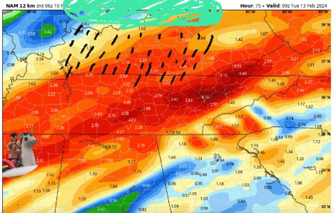
.I'm not sure. I didn't look at the hourly frames. But I did notice a couple of things. The accumulations shot further down into north AL and GA, but they clearly aren't all snow. The difference between the 10:1 and Kuchera is too much. I think it's sleet. I also think it's kinda pointless to look at it at such a fine grained level. There will be a warm nose somewhere, but there's no way the models are going to nail that down precisely. I still think the arctic air wins out and the sleet is minimal.
-
1
-
Tn Valley Severe Weather
in Tennessee Valley
Posted
Pretty fascinating that coastal CA has had more warnings than OHX.