

Rd9108
-
Posts
3,189 -
Joined
-
Last visited
Content Type
Profiles
Blogs
Forums
American Weather
Media Demo
Store
Gallery
Posts posted by Rd9108
-
-
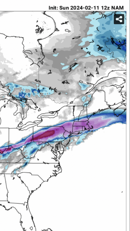
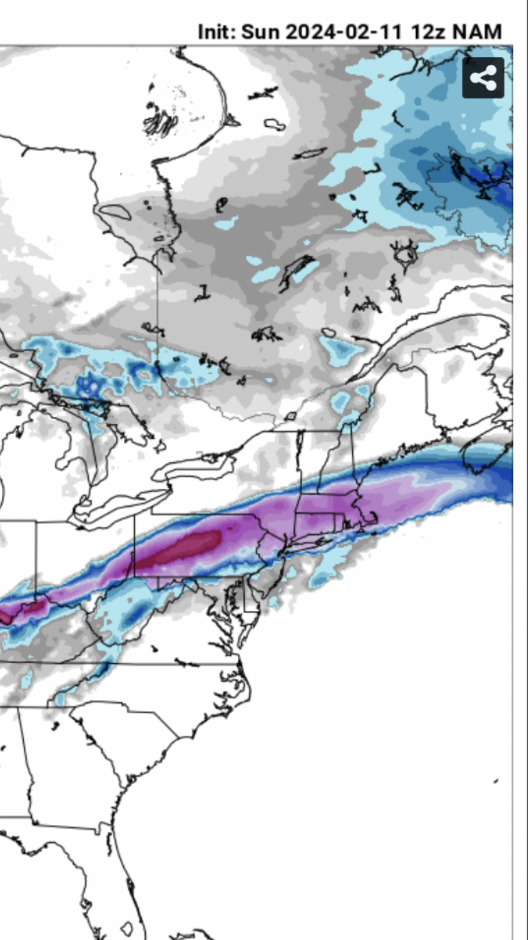
NAM is actually south 3k nice hit.
-
It's the euro ensemble at short range but it's definitely south of op and other guidance

-
3 minutes ago, TheClimateChanger said:
Impressive, and this 8.3” is with actual modeled ratios. This looks like it could be a big one.
Could be for sure. The models are still all over the place. I'm glad we have some of the mesos. Hopefully the next HRRR run shows a big hit again
-
UK continues to be south of other guidance

-
GEFS has gone south fwiw. We are within 36 hours now so the ensembles aren't as good but it's atleast a sign that maybe this is ticking south. Hopefully the euro shows the same.
-
Just now, Burghblizz said:
GFS looks like it might suck slightly less
It's slightly better. Every little tick helps with this and nowcasting may have some surprises good or bad.
-
 1
1
-
-
Hug the snowiest model and you can never go wrong....
Icon is south of it's previous runs. Let's just shoot for a period of heavy snow and I'll be happy.
-
 1
1
-
-
22 minutes ago, Burghblizz said:
12Z NAM 10:1 strip of 12+ just for fun. I think we would gladly take the old “cut in half rule” here:
3k is a lot warmer though. I guess it may actually come down to nowcasting.
-
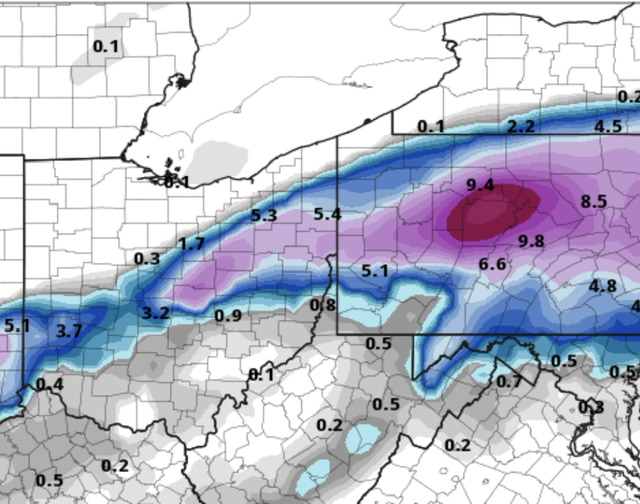
Infact the NAM has us at 8 inches now on the kuchera.
-
2 minutes ago, Burghblizz said:
NAM not giving up - in fact its better for SW PA
I seen that maybe we get a nice little correction back south. I'd love for the gfs and rgem to shift south. Still tracking atleast.
-
Just now, Storm Clouds said:
Dude please be respectful. We all want it to snow as much as you do, but sometimes your wishcasting and “grasping at straws” approach when things are clearly trending in the wrong direction are a bit much.
I mean doesn't help when Tim who is from my area comes in your forum and stirs the pot....
-
1
-
-
1 minute ago, Blizzard of 93 said:
Yes, it’s over because of 1 GFS run….
Great call, lol….
See you at 6z ….
Come on you know in your heart that the NW ALWAYS wins.
-
Gfs has gone even further north and starts to creep that mix line into Northern PA.
-
2 minutes ago, CoraopolisWx said:
Hopefully we still get a period of heavier snow. Don’t want a rain to dryslot to flurries scenario.
Tbh I want to see some semblance of south shift between now and 12z tomorrow or else your fear may come true.
-
I'm gonna laugh if the gfs decides to come back south.
-
1
-
-
2 minutes ago, TimB said:
Ok, technically it still gets us a decent total, but is this at all promising?
Nope because we know that pesky warm air always comes further north. Idt we ever get the opposite
-
1 minute ago, TimB said:
Once the bleeding starts, it never stops. We know this by now. Another wasted storm and likely another wasted winter.
Big game hunting at this point. Give me a 12+ storm and I won't even remember how bad this winter has been.
-
1
-
-
You guys might as well close this thread because at this rate it's gonna be rain all the way up to Cleveland.
-
With that being said the SREFs are also going North. If the NAM goes north than you can basically put a knife in this one. Unless models are underestimating the cold air push.
-
18z euro north again fwiw. Need to see some type of bleeding to the north stopped tonight or tomorrow or else this thing is going to Youngstown/Cleveland. NAM is next up.
-
1
-
-
Just now, TimB said:
It’s over. 6z GFS had the 6-8” line clipping a portion of the county, at 18z no one in Allegheny gets more than 3-4.
Atleast it's over now and not 24 hours out. Like I said too I have a feeling this forces the rain/snow line even further north than the gfs is modeled. Gotta see some changes at 0z tonight if there's any hope.
-
4 minutes ago, DDweatherman said:
Yeah I held on hope probably too long for us on this one for snow, it will probably keep leaking north taking MDT and some other areas out of much snow.
I hate to be that guy and I'm not trying to troll but it seems like in recent storms the warm air always pushes further north than the models project. I hope I'm wrong.
-
Gfs not budging. The low was slightly south of 12z before transfer but the area is just flooded with warm air. My guess is the gfs is most likely gonna be right unfortunately. It just seems like in recent years anytime there is any sign of warm air/warm tongue that it's always north of even the models. Any hope is the cold air pushes further south than progged/more confluence. I'm not saying this one is over, it's just that we most likely willnnot win in this scenario unless we see some better trends...
-

Lock it in. Would like to see the gfs either stop moving north or tick south or else Bernie Rayno is going to be right about the snow going just to the north of PGH.
-
1
-
Pittsburgh, Pa Winter 2023-24 Thread.
in Upstate New York/Pennsylvania
Posted
3k
12k