

Local Yokel Wx
-
Posts
735 -
Joined
-
Last visited
Content Type
Profiles
Blogs
Forums
American Weather
Media Demo
Store
Gallery
Posts posted by Local Yokel Wx
-
-
Just now, Met1985 said:
One thing I noticed is that we had what appeared to be rime ice everywhere this morning. There was ice all over the trees and the tops of bushes. Looking out over Haywood you can see some fog that has not lifted yet and of course Canton makes there own weather with the mill.
i noticed that as well. I drove 74 to Asheville this morning around 730a and going nearby Clyde (Jones Cove exit) the mill effect was in full swing, fog/low clouds much thicker than back in Waynesville and cleared right up once we drove past Exit 32, temp at 25°F.
-
 1
1
-
-
5 minutes ago, Met1985 said:
Had a low of 17 and already have heavy cloud cover.
20.8°F down the way in Waynesville
-
2
-
-
Went ahead and let the boss lady know I will not be in tomorrow (waynesville to asheville daily commute).
Still thinking 4" or more is possible for Waynesville, which is all I need to cover up the fields around us.
-
4
-
-
4 minutes ago, ncjoaquin said:
Normally conservative Jason Boyer WLOS throwing all his cards on the table for this one.
Indeed...
-
1
-
-
1 minute ago, jrips27 said:
Hey y’all! I’m pondering chasing this storm up in the southern mountains somewhere. Probably somewhere on the 64 corridor
Look at one of these -
cashiers- lake toxaway - brevard- Hendersonville
Thought I would turn to the local experts. Any advice in places that usually do good in these type of set ups?
Higher up the better, closer to the escarpment the better. Anything above 3000' will feature very good snow rates and all snow throughout the event.
Not factoring in lodging rates, I would push to Lake Toxaway and Sapphire Valley, but like you and @BlueRidgeFolklore have mentioned, anywhere along the 64 corridor will be gravy. If you can make the extra 20 min drive, Yellow Mountain nearby Lake Glenville is a decent spot with its 5k plus elevation and there are airbnbs up there.
-
4
-
-
By the way, thanks @Met1985 for being the voice of reason for this event! It's so easy to get excited and your reminders are helpful.
@BlueRidgeFolklore, your spot is a tough call for us. Sort of a battle ground between elevation and higher precip rates. Are you up 276 at all (above the town's elevation of 2100')?
-
2
-
-
2 minutes ago, Met1985 said:
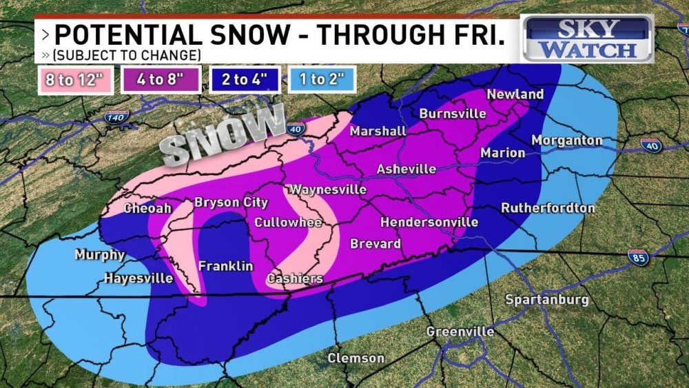
See this is what I don't understand is some of those holes in the SW mountains should be getting a lot more than it shows. Maybe something is up with the algorithm but this map looks off to me..
elevation issues and cold air not fully making it to the valley floor. I'd be surprised to see Bryson and the likes pick up more than 1 - 2". It also hurts there position related to upslope/downslope flow off the escarpment and highlands plateau.
Those valleys are the some of the most sheltered valleys around. Heck, Cullowhee in particular is one of the largest, deepest valleys in the Appalachians, surrounded by 5 - 6k foot ridgelines on every side but a sliver going through Sylva.
For Haywood, the northern portion the county will not get as much as those south of town going up 215 in the first round but the backend NW flow should make up for this. Maybe another downslope issue?
-
3
-
-
3 minutes ago, WxKnurd said:
Depending on how crazy I feel I might take a LONG hike on Saturday up to a hunting spot I never made it to this season in that area between Richland and Balsam off the parkway. Sits above 5000’. Lots of vert gain from the valley floor outside Cullowhee to the top so we will see, if I do I’ll take some pics and get some measurements. I think a 4” storm total is our highest at our house since we moved here in Feb of ‘19, so I’m hoping to finally break that at some point this season. Feel confident it happens by Tuesday next week but we will see. Still wanting a double digit storm too sooner rather than later lol.
I feel you on the double digit desire. For me, the cutoff for a good snow storm is covering the blades of grass. Used to be 2 - 3" but now our house sits on pasture land so our grass is much taller now, lol, pushing our "good snow" cutoff to about 4 - 6".
Gonna take a stab and guess where your spot is. Would it be up Caney near Rough Butt Bald or perhaps Piney Mtn? Not trying to uncover your honey hole, just curious being the GIS geek I am.
-
1
-
-
14 minutes ago, WxKnurd said:
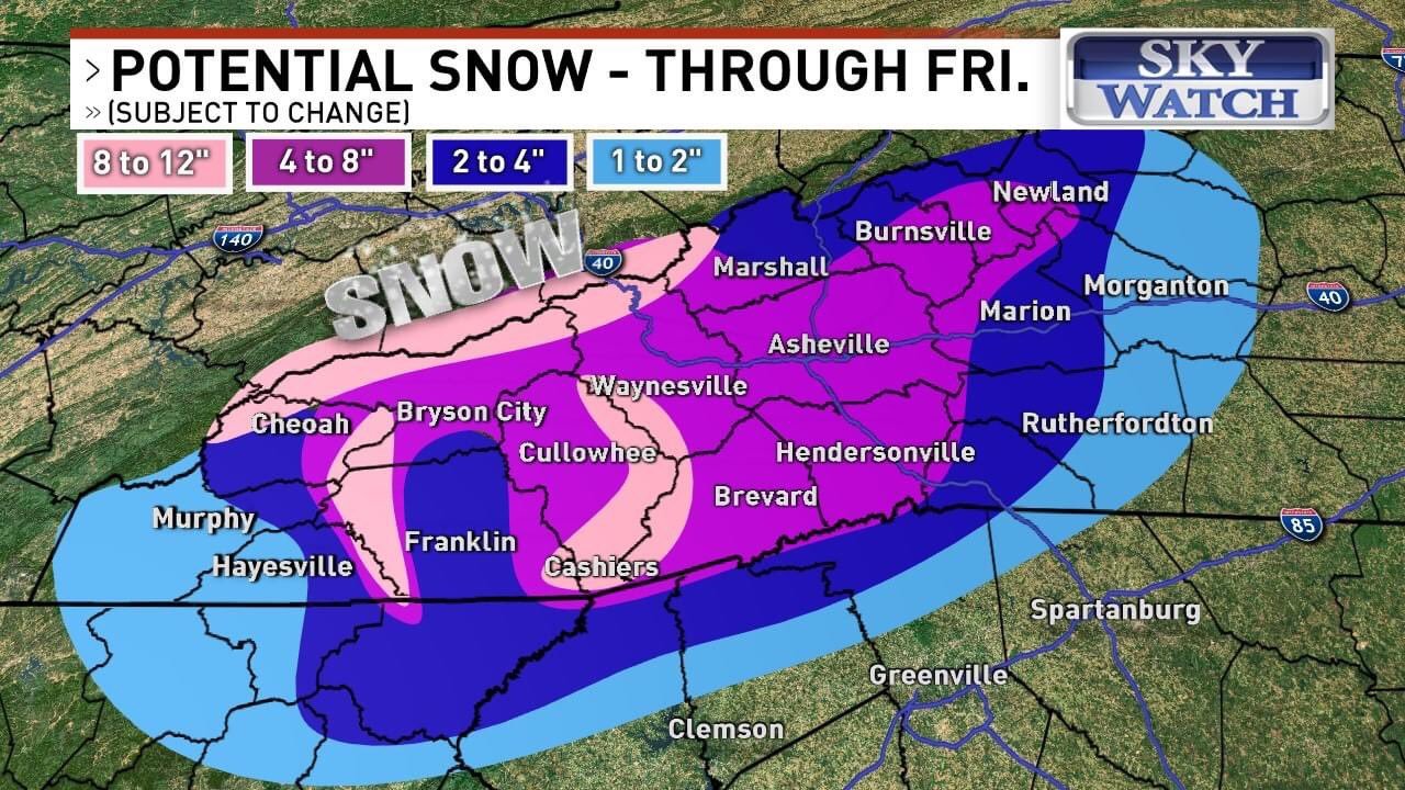
Been keeping an eye on models and everyone’s thoughts. Working up in Kingsport so gotta make the tricky drives over Sam’s Gap, through the Newfound Mtns and then the final one up to the house so trying to figure out if I need to head out Thursday night or if I’ll actually be able to work a few hours Friday. At least it’s all major Highway. All depends first on timing and then on amount, I’d rather drive when it’s clear and then get dumped on or navigate 1-2” of snow while I’m driving instead of driving during a paste bomb. Figuring 3-6” at the house is probably a good call. Southern Haywood on the rim of the Great Balsams looks to get raked.
A Southwest Special indeed. The Southern Highlands Plateau to the Great Balsams and most of southern Haywood should do really well. We're sticking to our snowcast map from yesterday and will narrow the ranges some, but your 3 - 6" for Balsam call is what I'm telling my friend up Chad Crawford.
If you're jonesing for snow and want to ride it out cabin style, the Highlands - Cashiers - Lake Toxaway corridor will be the easiest setup. Just be safe out there!
One of the things I'll be watching with this event is the front and back end snowfalls. I wonder if the Smokies will win out for highest totals compared to say Richland Balsam (or anywhere along the Great Balsams) bc of NW flow on the backside, but alas, we'll may never know the totals up and along the Great Balsams with so little observations.
I work for a non profit that manages the Shining Rock and Middle Prong Wilderness Areas and will reach out to our ranger to see if they can give us data/pics from their daily walkabout.
-
5
-
-
The deeper valleys in SW NC have me worried about lower totals and the escarpment is also an interesting curveball (higher totals with upslope). Could end up being a Southern Highlands Plateau special for our neck of the woods.
Early back of the envelope forecast for most of SW NC (populated areas) is 2 - 4" but we are holding off on our SNOWCAST map till later this afternoon; even then it might be premature.
The NW flow locations should do great either way.
-
1
-
-
4 hours ago, Maggie Ace said:
Moderate snow at Cataloochee this morning. Coming down pretty good and heavier than I expected!
-
3
-
-
Threw this on our social media feeds but I thought this group might appreciate this more so (a rain, not snow post)...
Highlands was 3.45" shy of beating Mt Mitchell for the annual rainfall state record of 139.94" in 2018.
Highlands broke it's own record on 11/12/20 & collected 136.50" of rain in 2020!
Past 3 years
- 2018 - 125.46"
- 2019 - 111.78"
- 2020 - 136.50"
1990 - 2010 annual average - 89.46"
-
5
-
5 hours ago, Hvward said:
Yep! 3 chances at snow for many over the next 10 days. Good times friends.It did thunder the other day.
-
2
-
-
Mt Lyn Lowry @ 6037' has been stuck at 36F for hours now, but its slowly beginning to drop, even with a light southerly wind.
-
2
-
-
5 hours ago, Hvward said:
Nice model spread regarding snowfall on the overnight models. Euro with the lowest for KAVL at 1” with GFS being the higher end 3”+. I hate forecasting these type fronts, but it seems the changeover could happen just as the sun is setting on Christmas Eve night. Timing is going to be key, and whatever falls will be on the ground for Christmas morning IMO.
I second that notion (motion). All those in favor say aye...
-
2
-
-
We'll see and pick up snow Thursday afternoon/overnight but the temps on Christmas Day will be brutal (not end of the world cold, but our first real slap in the face cold for the season). Our first foray into single digits territory is likely for our higher elevation folks.
-
5
-
-
Is there any talk of an upgrade for the new radar? My biggest complaint is the upload speed and I wonder if its tied to server space or the migration to the new radar
9 hours ago, wncsnow said:It's God awful. No matter which side of the fence you are on, it's obvious that the federal government has destroyed the national weather service...their funding is pitiful.
-
Snuck out a trace of snow last night here in Waynesville on car tops, tips of grass, and roof lines.
-
3
-
-
Any other Friday with snow its a big deal but throw Christmas Day into the mix and its already getting amped up on social media. We're telling our followers to hang tight, check back in on Monday.
47 minutes ago, Hvward said:3 Chances for snow coming up in the High Country over the next week. Sunday morning could be very interesting for many with the RGEM showing light icing being possible along the Escarpment, and snowfall above 3500'. Warm nose will be weak with this meager front. Then Monday night into Tuesday another wave will move through before the polar front passes by on Christmas. Lots to track here for sure!
-
1
-
 1
1
-
-
Hey Met, did you get anything up Crabtree?
Cat has seen steady snow all day and I was wondering about Crabtree.
-
1
-
-
Just the dusting for us but it was pretty while it lasted.
.thumb.jpg.6e21069eef7a61ddbc2bebf3fb1a21c9.jpg)
-
1
-
-
3 minutes ago, WxKnurd said:
Trace of sleet and graupel here. Headed to grab dinner and the top of Grassy Bald across 74 from me is white, Plott Balsam is white down to probably 4000’. Angle orientation wasn’t and isn’t right at this moment, just based on last year and this year I can tell the angle that Waynesville proper gets snow during a flow event is different than the angle I need to see decent flakes.
too funny, my friend over in balsam was complaining about just that. I'll take what i can get since im below 3500'
-
Managed a quick dusting here in Waynesville. Granular snow.
Temp 30F
-
4
-
-
CAA has yet to scour out the warmer temps in the deeper valleys as of midday. We don't expect anything to stick here of course but I find these NW flow/CAA/CAD events fascinating to play out on temp readings across SW NC
- Mt Lyn Lowery (6037') - 25°F
- Cat (5400') - 29°F
- Balsam (3310') - 34°F
- Waynesville (2755') - 37°F
- Sylva (2036') - 42°F
- Bryson City (1752') - 42°F
-
2
.jpg.cf1ec3af4adbb8c524e48650118b3a78.jpg)
2020/2021 Fall/Winter Mountain thread
in Southeastern States
Posted
I'm right there with ya. The evergreen plant impact is more noticeable, but my favorite is the Jackson Paper Mill in Sylva. I lived downtown about the Coffee Shop for years and would always notice its extremely small impact up and down Downtown and up Skyland a few miles at times.
I'll have to dig up some pictures i took of the stack extending over downtown or feeding a larger cloud/fog.