

Local Yokel Wx
-
Posts
735 -
Joined
-
Last visited
Content Type
Profiles
Blogs
Forums
American Weather
Media Demo
Store
Gallery
Posts posted by Local Yokel Wx
-
-
watching the shortwaves with interest. not expecting any change to our previous thoughts, but I'm sitting here in the office in AVL with partly sunny skies overhead, hoping for flurries around midday and maybe a dusting by the time I get home this evening back in Waynesville.
WxKnurd, my buddy in Balsam says notta so far, i assume the same for you (10:30am). Y'all should experience some worthy snow showers this afternoon. Cat is putting on a decent show all morning on the webcams.
-
 2
2
-
-
Just now, WxKnurd said:
Good to see you back posting more local, always enjoyed your posts when you would fire up the guns when I was down in Charlotte. Seems we’ve got Haywood and it’s microclimates covered pretty good with posters.
Thanks WxKnurd. SW NC is truly being represented on this thread at least. One of these days we need to put this network to use, for what I don't know, but this many enthusiasts in one area has potential for something.
I like your spot for an inch or two but you probably already know that. I have a dear friend who lives off Chad Crawford Rd and I told him to expect at least one inch, maybe two.
I say that but I also reminded him that I called for a half inch last Mon/Tues and he ended up with 2.75", so he knows to take my input with a chunk, not a grain, of salt.
-
2
-
-
1 minute ago, Met1985 said:
Oh yeah well I have two homes which gives me a neat perspective on the microclimate in the area. One in Crabtree and one off of Stamey cove rd back in a holler. Its amazing what just a half mile down the road does at either a plus or minus for snow.
Yes I ended up in the Bethel district for my kids which im happy about.
The 12z Nam is even kill with a decent event. I know the snow maps are unimpressive but I do like the look of this little event.
I keep wondering about the initial build up of moisture and if SW NC can squeeze out light snow during the pre dawn hours before the bulk arrives closer to midday but from the NW at that time. Nothing that really collects but enough to see snow fall during the commute. Tough call either way.
I see Hunter just put up his initial thoughts and will go with a deeper dive at 7pm. I'm not able to do a late post so I'm working on mine now, going with light snow around sunrise, ramping up to scattered snow showers and solid NW flow late morning through the afternoon hours.
I might squeeze out a dusting here next the Mtn Research Station (open valley) but you should fair better in Crabtree, perhaps 0.5 - 1". That sound right to you?
I think Cat could end up with 2 - 3" by Monday evening.
-
2
-
-
1 minute ago, Met1985 said:
Nice to see you posting more.
Thanks Met! Life is slowly getting back into a better rhythm so I can spend more time on the weather.
Hope Haywood is treating you well, although I do miss the Addie connection in Sylva for reports. I assume Crabtree is a step up for snowfall. We looked at property out there for the schools but ended up in Waynesville; its a crazy market out there.
I'm digging into tomorrow's event right now, although light, at least we have something in play.
-
1
-
-
22°F at the house. Frosty (as well) this morning in Waynesville
.thumb.jpg.296de24ba335b77ed27c6fb17b7d6fa6.jpg)
-
5
-
-
Highlands is going to break past the 130" barrier Friday night.
Currently at 128.96" with 1.5 - 2" in the forecast Fri - Sat.
Still a ways to go to beat the state annual rainfall record, but its 2020 and we have roughly one month left.
-
Same here in Waynesville Wed morning and was able to edge back to 16.7°F again this morning.
22 hours ago, Sw NC weather said:Got down to 16 degrees here by far the coldest morning of the season.
-
3
-
-
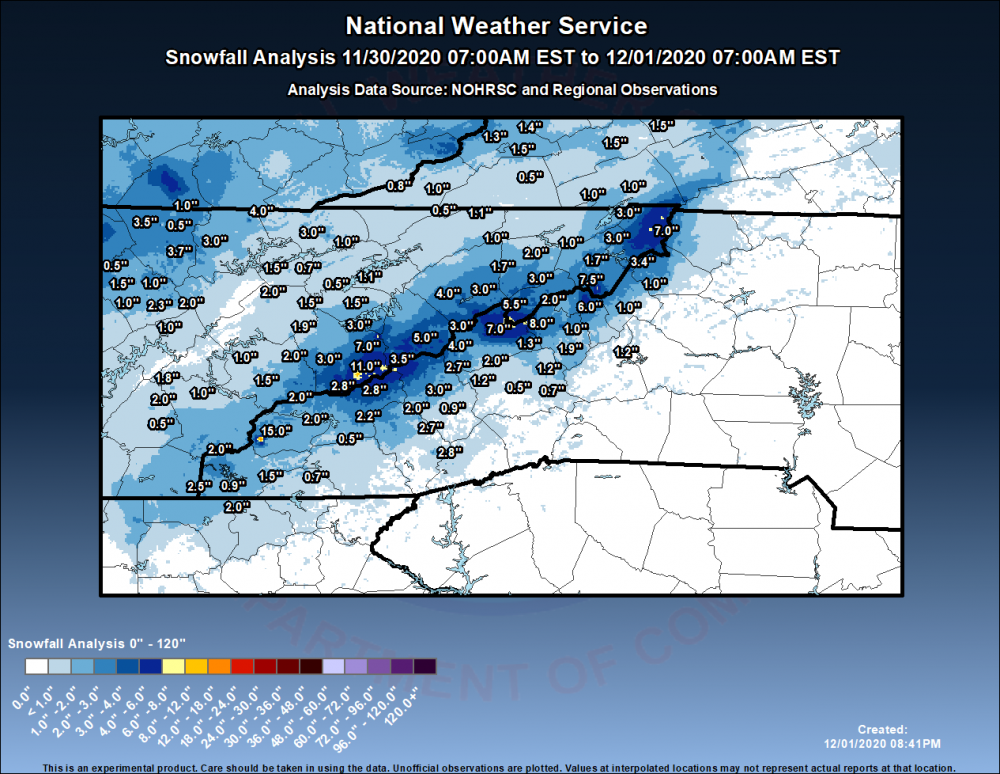
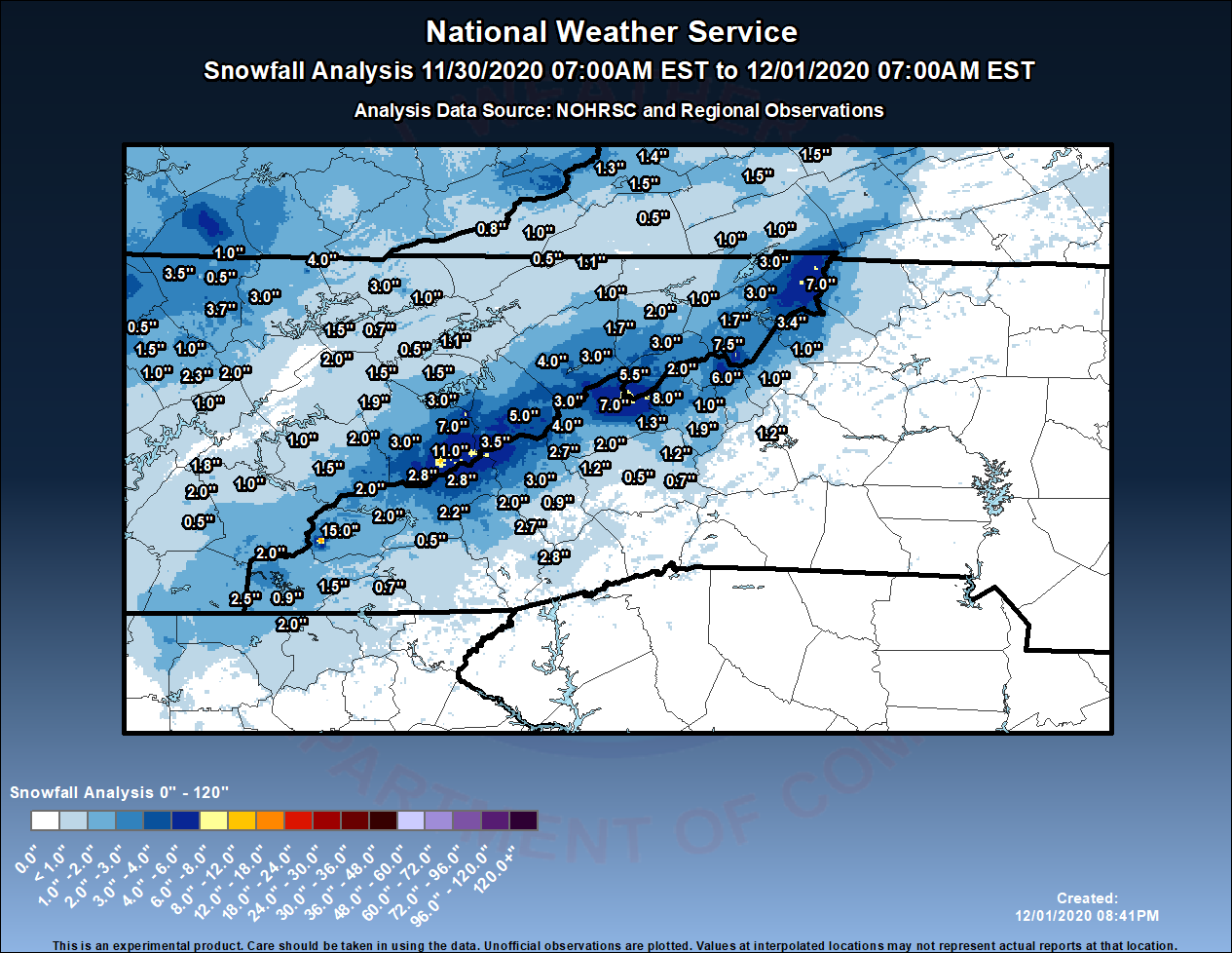
The Skyway total is amazing.
I can literally throw a stone at the Mtn Research Station from our property. We ended up with just under an inch here in Waynesville.
Below is the NWS post storm analysis map. Not too shabby.
Link to the arcgis dashboard storm total map that's interactive: https://noaa.maps.arcgis.com/apps/opsdashboard/index.html#/4fe985838e464fb9bb980799443e01b6
Lastly: If you don't follow Evan Fisher check him out. He has been killing it lately these past few years with event videos and now is evolving into maps.
Ground blizzard conditions up on Roan Mountain:
-
2
-
-
Happy Belated Thanksgiving everyone!
Looking forward to our first round of measurable snow this year. If it doesn't pan out like we hope (even a decent NW flow event), we'll fire up the snow guns at the house on Tuesday.
-
2
-
-
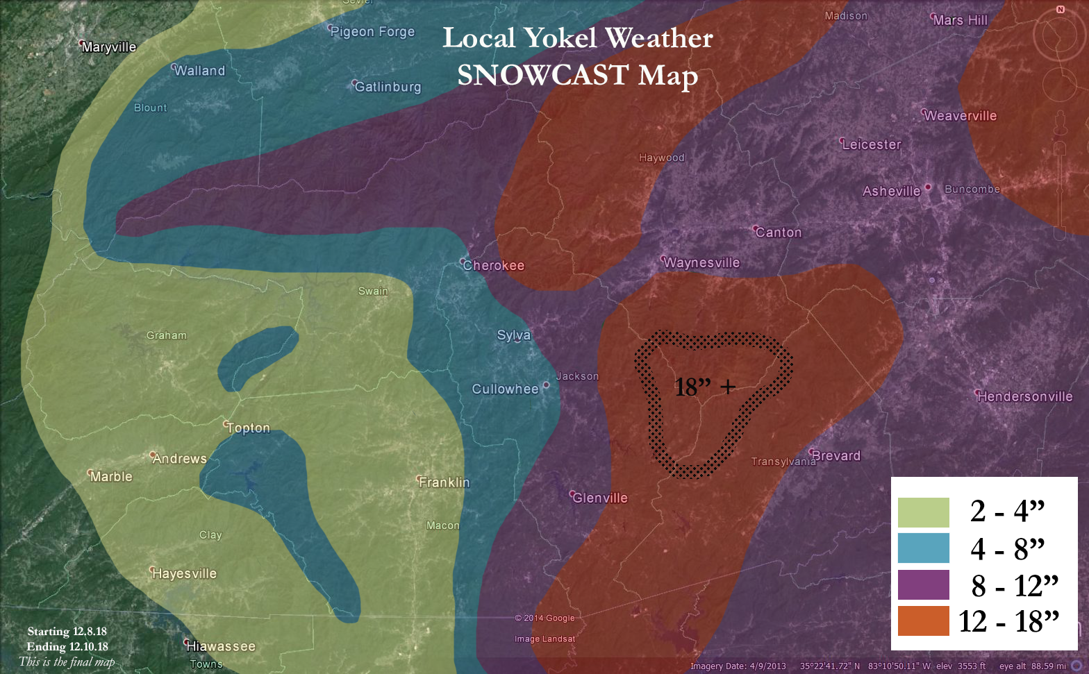
Notable totals for our neck of the woods as of 8:30am...
16" Cataloochee
14" Cullowhee Mtn
10" Downtown Waynesville
2 - 4" Sylva and Cullowhee (valley)
-
2
-
-
A livestream driving along I 40. The guy is currently in downtown Asheville
-
a conservative map and a tough call.

-
1
-
-
5 minutes ago, Berlin1926 said:
So, if you live in Person, Granville, Vance, and Warren for example, snow totals will be determined by the state line. I don't disagree with the assessment, but the graphic needs work.
His focus/expertise is Asheville and WNC, not the VA/NC state line.
-
4
-
-
13 minutes ago, franklin NCwx said:
Its gonna be interesting to see if the snow line falls at the balsams or is able to push back to the AT on the clay/macon line.
If we can get the NE winds shown on the nam and the rates it might workout here. It could just as easily be a few inches of slop!
If the cold can push up and over/around the Great Balsams/Southern Highlands Plateau it should be able to surpass the Cowee Mtns as well. I do fear the Great Balsams will be the dividing line. But hey, that's what makes this part of the state one of the toughest areas to forecast.
-
1
-
-
2 minutes ago, BlueRidgeFolklore said:
From Highlands to Hendersonville are going to get lambasted.
Hope you didn't read those totals as estimated amounts but more so the example of extending the range for the snow map. You're in a prime spot as well!
-
5 minutes ago, franklin NCwx said:
I'm confident highlands will be good. Gonna be a big score or heartbreaker here.
Yea, the Southern Highlands Plateau is a safe bet for us. Franklin is a tough call with Bryson a close second. Our final map comes out later this morning but I think we'll push a larger than usual snow total range (instead of the usual 1 - 2", go with 1 - 4" for example) to show the uncertainty as it relates to distance between totals, location and elevation. A fun storm to track no doubt and I'm curious to see what Lake Toxaway reports when its all said and done. Have a safe and fun time bud!
-
18 minutes ago, burrel2 said:
I honestly can't decide what it's going to do in the northern upstate. I think the most logical outcome is mostly cold rain, but there's definitely a chance we could get buried. I'll remain cautiously optimistic, but expect 1 inch of sleet accumulation for my storm total.
If that lead finger of precip could be mostly snow for us, we could really rack up. It appears the mid-levels will be borderline cold enough for the finger... but surface temps are around 35-37. If the mid-levels are cold enough, i imagine we could cool the surface down to 32-33 with heavy rates inside the finger.
Regardless, the mountains on the NC/SC border are going to get obliterated, both by the lead finger and the main storm. I'm calling the jackpot for the storm as somewhere around rosman/brevard with a total of 20 inches.
I agree, the escarpment just off the Great Balsams will be the prime spot for our area. We're pulling our hair out over here trying to nail down where the cutoff line will be from sleet/light snow to heavy snow. A good number of folks in SW NC will be disappointed, more so Macon/Jackson moving southwest, Haywood looks like a lock for a heavy event.
-
22 minutes ago, franklin NCwx said:
Same here. It's more bullish than the sref which drops 2.5 here. The 6z rgem was a general 2-4. Hopefully that bumps up on the 12z run.
I agree. Southern Plateau is in a better spot for the Friday event than say Maggie Valley. Tables turn for the Saturday event.
We're going with 2" for Highlands as a middle of the road forecast.
-
Im 6' 4" to give ya reference as to how big this tree was...
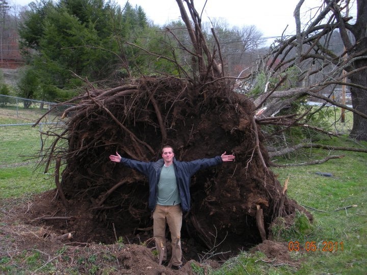
And a more goofy one...

.jpg.88911f2026c2d52425761b50c72e9de6.jpg)
2020/2021 Fall/Winter Mountain thread
in Southeastern States
Posted
finally a flizzard here in downtown Asheville