Physicsteve
-
Posts
181 -
Joined
-
Last visited
1 Follower
About Physicsteve

Recent Profile Visitors


-

E PA/NJ/DE Summer 2026 Obs/Discussion
Physicsteve replied to PhiEaglesfan712's topic in Philadelphia Region
Really impressive and dangerous temperatures and heat indices yesterday and today. With the deep cold earlier this year we have to be close to some record disparities between various metrics in a calendar year. It’s about as hot as it gets and was about as cold as it gets ‘round these parts. hope the nam’s right and we get some thunderstorms out of this soup this evening -
E PA/NJ/DE Summer 2026 Obs/Discussion
Physicsteve replied to PhiEaglesfan712's topic in Philadelphia Region
Heads up, Doylestown!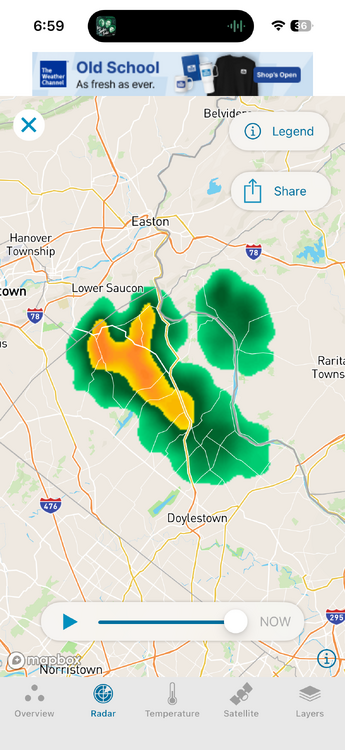
-
E PA/NJ/DE Summer 2026 Obs/Discussion
Physicsteve replied to PhiEaglesfan712's topic in Philadelphia Region
Constant rumble of thunder the last 2-3 minutes. Keeping an eye on that cell. Didnt think I could be headed to the basement today. eta. Rain picking up in intensity -
E PA/NJ/DE Spring 2026 Obs/Discussion
Physicsteve replied to PhiEaglesfan712's topic in Philadelphia Region
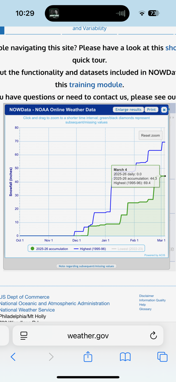
Was a pretty 95-centric winter, at least that’s how it seemed. I’m just northwest of Trenton and am sitting at ~44.5”, while my area’s average is 21. Hopefully next year continues the recent trend of better winters and everyone cashes in. Now bring on the 70s and 80s. Between the snow melt, rain, and warmth, we’re gonna be firing up those mowers in about a month.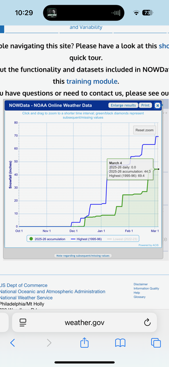
-
E PA/NJ/DE Spring 2026 Obs/Discussion
Physicsteve replied to PhiEaglesfan712's topic in Philadelphia Region
The second of those weeks could be our last trackable window, say 3/15-20. eta: fantasy land caveats apply -
E PA/NJ/DE Spring 2026 Obs/Discussion
Physicsteve replied to PhiEaglesfan712's topic in Philadelphia Region
Had a little sleet to start and now plain drizzle. Like Agnes, very light rates so far. -
E PA/NJ/DE Winter 2025-26 Obs/Discussion
Physicsteve replied to LVblizzard's topic in Philadelphia Region
Lol well yes Ill admit to being a sinning weenie. I like extremes which includes the heat and storms of summer which I understand you and many others despise. Locally I have to go A+ especially considering my weather 2011 onward. Region-wide though I think B grades are fair. Missed a couple of big dogs by the hair on our chinny-chin-chins and the snow event frequency could've improved with a few smaller events. We started the season with clippers reemerging as a path to some frequent refresher snow but that petered out, though obviously still a NS-dependent winter. Obs: sunny, fog is burning off, and birds are chirping -
E PA/NJ/DE Winter 2025-26 Obs/Discussion
Physicsteve replied to LVblizzard's topic in Philadelphia Region
Honestly think best case is cashing in snow-wise Monday like Euro AI shows, realizing most or all will be melted and washed away by the weekend. -
E PA/NJ/DE Winter 2025-26 Obs/Discussion
Physicsteve replied to LVblizzard's topic in Philadelphia Region
Hope that works out thermals-wise, though I am suspicious of a widespread all-snow event unless we get dynamics going for us again. Snow to rain has been modeled with this more than once. -
E PA/NJ/DE Winter 2025-26 Obs/Discussion
Physicsteve replied to LVblizzard's topic in Philadelphia Region
Im cool with snow until astronomical Spring. After that bring on the blooming, lighter clothes, and open car windows (thanks sun angle!). We’ve had a lot of Winters recently that have just been slightly cooler Springs, but this has felt like a wall-to-wall winter so whenever the change in season happens will be welcome this year. (Still hoping the western crew can at least get a consolation event to end things) -
E PA/NJ/DE Spring 2026 Obs/Discussion
Physicsteve replied to PhiEaglesfan712's topic in Philadelphia Region
Would think it'd start to show up on the mesos at this point and none are biting. Gfs seems to be on its own like the rgem was with the last system. -
E PA/NJ/DE Winter 2025-26 Obs/Discussion
Physicsteve replied to LVblizzard's topic in Philadelphia Region
Ended with something resembling an inch but no actual measuring occurred. Let’s end this awesome winter with a bang march 2/3. Maybe then even birds will go A+ while the rest of us add more pluses (plusses? Plusi) -
E PA/NJ/DE Winter 2025-26 Obs/Discussion
Physicsteve replied to LVblizzard's topic in Philadelphia Region
Been snowing since 5, maybe 1/4” otg with heavier returns on the doorstep as the finale. -
Blizzard of 2026 Storm Thread/OBS
Physicsteve replied to Mikeymac5306's topic in Philadelphia Region
Overall the timing of the storm was probably near perfect regarding the heaviest stuff falling at night, even though in general @RedSkyis right daytime snow is preferred. Hopeful the hrrr’s that showed it throwing snow back over the area through morning were right and we can eek out another inch or more. -
Blizzard of 2026 Storm Thread/OBS
Physicsteve replied to Mikeymac5306's topic in Philadelphia Region
Go lakehurst, go!