

Doramo
-
Posts
229 -
Joined
-
Last visited
Content Type
Profiles
Blogs
Forums
American Weather
Media Demo
Store
Gallery
Posts posted by Doramo
-
-
I'm doing great . Hot one for the last day of Sept. with 90 degrees out today

-
From what I have been seeing / reading about snowfall predictions is that we will receive an average snow total . Based on what I have found for here that would be 8" . I would think that If the average of the last four years is figured into it then it would be less .
-
43 days for south central/southwest Missouri is way off . Here in Ozark county / southern Mo., has not hat a Winter Storm Warning the last two yrs or so .
-
Well the temp here is 28 and I hope it holds to at or below the freezing mark . That and it would be nice to see the low go a little farther south ...don't like freezing mix slop as we have had enough of it already .
")
-
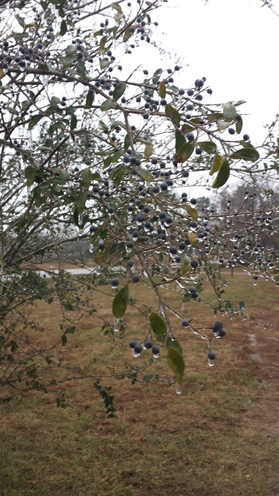
Light freezing rain occurring here so far
-
Got huge 2" of snow ...I am grateful that we got that much and wished that all members would have got some .
-
 2
2
-
-
Had the same here earlier..
36 minutes ago, NwWhiteOut said:Got some really fine snow flurries falling here. Been looking like it wanted to all darn day!
-
1
-
-
     It has been 32 all day here with light freezing rain so far .
 The trees and bushes are glistening with ice and small ice cycles .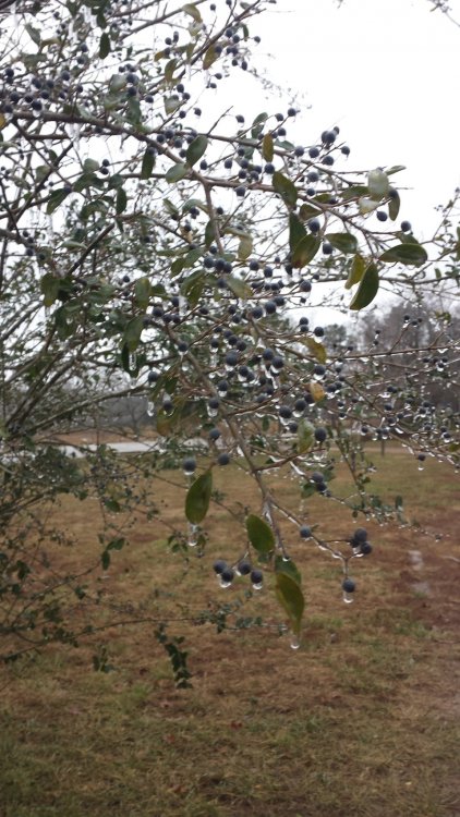
-
2
-
-
When I see it ---- then I will believe it .
-
The models are pushing this farther south of which I hope it readjusts back toward the north .

https://forecast.weather.gov/
DAYS TWO THROUGH SEVEN...Wednesday through Monday.

Light snow may be possible Wednesday night into Thursday night.
There remains uncertainty on the exact track of this system, so
there are questions on how much of the area will be affected. At
this time far southern Missouri will have the better potential for
seeing any snow across the outlook area.
-
Huh? One would think with the forecast being only two days away things would come to a settled prediction but ? NWS Springfield,MO
"Interesting forecast ahead as models continue their differing
run to run solutions with the approach of the upper closed low
tracking through the Southern Plains.

Ah what a difference 12 hours makes. The 12z NAM offered
continuity with the 00z ECMWF initially offering a boost in
confident...then the 12z ECMWF came into line with the previously
outlier GFS...which now leaves the NAM as the outlier which
offered a solution that coupled the upper level jets associated
with the approaching upper low and shortwave over the Great Lakes
occurs. While the juxtaposition isn`t ideal...the ageostrophic
flow enhances lift throughout the column particularly above 700 MB
and enhances frontogenesis. Further the NAM shows a response in
the low levels with a significant surge in the low level moisture
advection as the system approaches the forecast area. This is all
while sub freezing temperatures arrives with this system
...resulting in a concerning amount of freezing rain.

Again while this would lead to a greater impact and still needs to
be monitored...the evolving model solutions have largely come in
line with the 00z GFS in tracking the system well southward...
reducing accumulations of a wintry mix on Wednesday
night/Thursday. However...this solution leads to wraparound lift
on the back side of the system and the development of snow
accumulations into Friday.

I must suggest caution in this deterministic determination as
later runs will be critical in determining the temperature profile
of the lower atmosphere."
-
Not much being said at NWS Springfield for my area,, just this:
A light wintry mix will fall from Wednesday night into Friday
morning...with the precipitation changing over to rain for a
period Thursday.
At 80% chance for slop . Still have time for significant changes (for the better I Hope)
-
16 hours ago, MUWX said:
Pretty quiet in here, last bust scare everyone off?
Yep!
-
The pattern is fixing to change for the better
-
1
-
-
Merry Christmas Y'all Maybe snow by the 30th (?????) is showing up on the local online forecasts . To me, just a mention of snow gives me hope and is much better than no mention at all like it has been lately .
-
1
-
-
33 minutes ago, StormChazer said:
Something may be lurking around the new year.
It's the snow monster


-
4 hours ago, JoMo said:
11th? Not good? There might be a system around the 14th or so in your area. We'll see. You can see what happened to this threat, lol
thanks
-
18 run Nam 54hr shows freezing rain for NW Ark and southern Mo...yuck!
http://coolwx.com/cgi-bin/getptype.cgi?region=us&model=nam&run=18&fhr=18&field=ptype
-
1 minute ago, The Waterboy said:
3k NAM at 18z wasn’t bad.
There is a chance then
-
Any good news?
-
With this event in limbo,(Not over till the fat lady sings) how about the chances of snow on the 11th?
-
weather.gov
National Weather ServiceWatches, Warnings & Advisories
Go to the NOAA Homepage
NWS Homepage
Local weather forecast by "City, St" or zip code
City, St
One product issued by NWS for: Dora MO Share |
Winter Storm Watch
URGENT - WINTER WEATHER MESSAGE
National Weather Service Springfield MO
348 AM CST Thu Dec 6 2018...Winter Storm Possible for far Southern Missouri...
MOZ093-095>097-101>106-070000-
/O.NEW.KSGF.WS.A.0001.181208T0600Z-181209T1200Z/
Newton-Christian-Douglas-Howell-McDonald-Barry-Stone-Taney-Ozark-
Oregon-
Including the cities of Neosho, Nixa, Christian Center, Ozark,
Selmore, Vanzant, Ava, Goodhope, Rome, Squires, Dogwood, Pomona,
Pottersville, Siloam Springs, South Fork, West Plains,
White Church, Anderson, Noel, Goodman, South West City,
Pineville, Rocky Comfort, Monett, Madry, Cassville,
Kimberling City, Crane, Elsey, Indian Point, Silver Dollar City,
Branson, Hollister, Kirbyville, Edgewater Beach, Forsyth,
Ozark Beach, Powersite, Wasola, Thayer, Alton, Couch, Greer,
Thomasville, and Wilderness
348 AM CST Thu Dec 6 2018...WINTER STORM WATCH IN EFFECT FROM LATE FRIDAY NIGHT THROUGH
LATE SATURDAY NIGHT...* WHAT...Heavy snow possible with some mixed precipitation. Total
snow accumulations of 3 to 6 inches with locally higher amounts
possible. Ice accumulations of a light glaze possible.* WHERE...Along and south of a Neosho to Ava to Alton, Missouri
line.* WHEN...From late Friday night through late Saturday night.
* ADDITIONAL DETAILS...Plan on slippery road conditions.
PRECAUTIONARY/PREPAREDNESS ACTIONS...
A Winter Storm Watch means there is potential for significant
snow, sleet or ice accumulations that may impact travel. Continue
to monitor the latest forecasts.&&
$$
Schaumann
U.S. Dept. of Commerce
NOAA National Weather Service
1325 East West Highway
Silver Spring, MD 20910
E-mail: [email protected]
Page last modified: May 16, 2007
Disclaimer
Credits
Glossary
Privacy Policy
About Us
Career Opportunities
NATIONAL WEATHER SERVICE: for Safety, for Work, for Fun - FOR LIFE -
Right in the heart of no winter storm warnings
 The only area that has more days of lack is southern Louisiana (edit I over looked Northern Texas ). This miserable record has got to be broken soon .
-
9 hours ago, JoMo said:
This is pretty nice...

Nice Blocking but not good for polar fronts..... Got about 2" of snow last night . Enough to make it look pretty . I hope this is just the snowy preliminary for this coming winter
MO/KS/AR/OK 2019-2020 Winter Wonderland Discussion
in Central/Western States
Posted
I'm loving it